
Hide
Fordyce
hide
Hide
hide
Hide
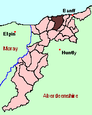
See the Maps Section below for links to
a fully-detailed version of this location plan.
Hide
Hide
"The parish, including the whole of the quoad sacra parish of Portsoy, is of a quadrangular form, irregular, however, and approaching nearly to that of a triangle. Its greatest breadth, in a straight line along the sea-coast, is 6 miles; its least, at the southern extremity, 2 miles; its greatest length, from the mouth of the Burn of Boyne to the top of the Knock Hill, 8 miles; and its least, from Logie Head to the same point, 7 miles. The number of square miles in the whole parish is about 28. It is bounded on the north, by the Moray Frith; on the west, by Cullen, Rathven and Deskford; on the south, by Grange and Ordiquhill; and on the east, by Ordiquhill and Boyndie. The general appearance of the parish is irregular, and presents considerable variety of hill and dale. In its centre rise the hills of Durn and Fordyce, extending continuously, and in a crescent form, from north-east to south-west; while the Knock Hill, in the south, rears its head still more majestically, and is seen as a landmark from a considerable distance at sea. The height of the Knock is from 1200 to 1400 feet above the level of the sea, and that of Durn about 700 feet. . . The coast is rather bold and rocky. It is intersected by two bays, that of Portsoy, where there is a safe and commodious harbour for ships, and that of Sandend, where there is a sandy beach about half a mile in length, with a small creek at the Redhyth Point, in which vessels of very light tonnage occasionally moor. The principal headlands are the East and West Heads, so called from their relative position to Portsoy, and Logie Head, at the western extremity of the parish." [Contributed in February, 1842, by the Rev. Alexander Reid, Minister of Portsoy, to The New Statistical Account of Scotland, Vol. XIII.]
Hide
Monumental Inscriptions for Fordyce have not been published. However, Aberdeen And North-East Scotland FHS (ANESFHS) have some unpublished MIs for the parish. Members may request lookups.
These are included in the Online Index to the MIs
Aberdeen And North-East Scotland FHS (ANESFHS) have published a name Index to the 1851 Census for Banffshire. Fordyce (together with Cullen and Deskford) is published as code AA214.ANESFHS also hold unpublished indexes and transcriptions of the 1861 Census for most Banffshire parishes (including Fordyce).
| Fordyce, Church of Scotland |
Kirk of Scotland
- OPRs held by the General Register Office, Scotland
GROS Baptism Marriage Death 153/1 1665-1739 153/2 1740-1774 153/3 1775-1819 153/4 1723-1819 1718-1807 163/5 1820-1854 1820-1854 1837-1854 - LDS Film Numbers:
Baptisms Marriages Deaths 6902563(3) 6902564(2) 990992 - Batch numbers (for familysearch)
Baptisms (C) Marriages (M) 111531
111532
111533
111534111531
111532
111534
Free Kirk
The following registers of the Portsoy congregation are held at the National Archives of Scotland with the catalogue numbers shown:
- Session Minutes, containing B & M: 1843-1855 (CH3/265/1)
- B: 1875-1915;D: 1896-1915; M: 1896-1915 (CH3/265/10)
Catholic Church
Copies of the following records for Portsoy are held at the National Archives of Scotland with the catalogue numbers shown:
- B: 1822-1839; D: 1874-1962 (RH21/30)
Kirk Session Records
Kirk Session records generally include records of Discipline, which often include information on illegitimate births, and Accounts, which may mention persons on Poor Relief. The surviving Fordyce Kirk Session records are listed on a separate webpage.
- Ask for a calculation of the distance from Fordyce to another place.
There is a wide range of maps available for Fordyce, historical and modern, on paper and online. Many ancient placenames continue in use, and will therefore appear on modern maps, but as parishes ceased to be of any significance for Local Government in Scotland in 1974, parish boundaries will be found only on historical maps.
Maps on Paper
- The best general-purpose modern printed map is the Ordnance Survey "Landranger" Series, which has a scale of 1:50000 (about one-and-a-quarter inches to a mile). Fordyce will be found on "Landranger Sheet 29".
- Reproductions of late-19th century Ordnance Survey maps are published by Caledonian Maps, and are also available via Family History Societies. Fordyce will be found on sheets 86 and 96.
Maps Online
- The small location plan at the head of this page is based on an 1845 map included in the Banffshire volume of the New Statistical Account of Scotland. View a fully-detailed version of this map.
You can see maps centred on OS grid reference NJ569616 (Lat/Lon: 57.642299, -2.723831), Fordyce which are provided by:
- OpenStreetMap
- Google Maps
- StreetMap (Current Ordnance Survey maps)
- Bing (was Multimap)
- Old Maps Online
- National Library of Scotland (Old Ordnance Survey maps)
- Vision of Britain (Click "Historical units & statistics" for administrative areas.)
- Magic (Geographic information) (Click + on map if it doesn't show)
- GeoHack (Links to on-line maps and location specific services.)
- All places within the same township/parish shown on an Openstreetmap map.
- Nearby townships/parishes shown on an Openstreetmap map.
- Nearby places shown on an Openstreetmap map.
You can view a comprehensive Gazetteer list for Fordyce including placenames culled from the Ordnance Survey "Explorer" (1:25000) map, the 1896 Ordnance Survey 1" map, the 1841, 1851,1861 and 1881 Census and Thomson's "Atlas of Scotland" (1832).
Under the "Poor Law Amendment Act, Scotland" (1845) responsibility for Poor Relief was taken from the Parishes of the Kirk of Scotland, and vested in new Parochial Boards, whose territories largely coincided with the old parishes. The Parochial Boards were not (as in England) grouped into Poor Law Unions, and there were few Poorhouses outside the cities and large towns.
Day-to-day administration of the Poor Law was in the hands of the Inspector of the Poor for each parish, and these Inspectors were obliged by law to maintain detailed records of applications and of relief supplied. The most valuable of these are the "Record of Applications" and the "General Register of the Poor". The "Minutes" are very variable, but on occasion can also contain information on named individuals.
The following Poor Law records have survived for the Parish of Fordyce:
- Minutes
These are held by Aberdeen City Archives. The records are available for viewing, subject to the 100-year rule.
(According to New Statistical Account:)
Year 1755 1782 1801 1811 1821 1831 Population 3212 3425 2747 3245 3364 (According to Ordnance Gazetteer:)
Year 1831 1841 1851 1861 1871 1881 1891 Population 3364 4145 4153 4289 4268
You can also see Family History Societies covering the nearby area, plotted on a map. This facility is being developed, and is awaiting societies to enter information about the places they cover.