
Hide
Inveravon
hide
Hide
hide
Hide
See the Maps Section below for links to
a fully-detailed version of this location plan.
Hide
Hide
"Consisting, in by much the larger proportion, of moorland and mountain, this extensive parish has upon the whole a bleak and barren appearance, particularly when entering the lower end of the parish (by the toll-road) from the east; but along the rivers, near the banks of which both the arable land and natural woods chiefly lie, the prospect is in general pleasing, and occasionally highly picturesque and attractive. ... A lofty range of mountains extending from Benrinnes to the Aven divides the lower part, or what may be termed Inveraven proper, from Glenlivet - while some six or eight miles further on, Glenlivet is itself divided into nearly equal parts by the Bochle, a high hill rising up in the centre of the valley... These three districts, thus divided by natural boundaries, are pretty well equal in point of extent, and have an average population of about 900." [From the article contributed to The New Statistical Account of Scotland in 1836 by the Minister, the Rev. William Asher.]
Hide
Aberdeen And North-East Scotland FHS (ANESFHS) have published a name Index to the 1851 Census for Banffshire. Inveravon (together with Kirkmichael and Tomintoul) is published as code AA218.ANESFHS also hold unpublished indexes and transcriptions of the 1861 Census for most Banffshire parishes (including Inveravon).
| Inveravon, Church of Scotland |
| Scalan Old Seminary, Ballindalloch, Roman Catholic |
Kirk of Scotland
As with other large parishes, Inveravon needed more than one church to comfortably service the population. The parish church lay at the western end of the parish, and from the mid-18th century, there was a "Mission on the Royal Bounty" for Glenlivet. However, this Mission does not appear to have kept separate Registers.
- OPRs held by the General Register Office, Scotland.
GROS Baptism Marriage Death 157/1 1630-1819 1630-1819 1636-1783 157/2 1820-54 1820-54 1844-54 - LDS Film numbers:
Baptisms Marriages Deaths 6902571(2) 6902572(1) 990997 - Batch numbers (for FamilySearch)
Baptisms (C) Marriages (M) C111571 M111572 Catholic Records
Writing in the 1836, the Minister of Inveravon wrote:
"In Glenlivet, where about three-fifths of the people are of the Roman Catholic persuasion, there are two Roman Catholic chapels, - the one at Tombia, pretty far up the glen, - the other at Chapeltown, in the Braes of Glenlivet. The former is a large building capable of containing from 800 to 1000 persons, - but only partly finished; the latter contains about 300."The following records are held at the National Archives of Scotland with the catalogue numbers shown:
- Chapeltown: Baptisms 1829 -1970; Marriages 1829-1970; Confirmations 1834 -1855 Deaths 1834 -1855: (RH 21/17)
- Tombae: Baptisms 1812 -1967; Marriages 1817 -1970; (RH 21/34)
Kirk Session Records
Kirk Session records generally include records of Discipline, which often include information on illegitimate births, and Accounts, which may mention persons on Poor Relief. The surviving Inveravon Kirk Session records are listed on a separate webpage.
- Ask for a calculation of the distance from Inveravon to another place.
The southern part of the parish, Glenlivet, was in 1865 raised to the dignity of a quoad sacra parish. More significantly for BDM and Census data was its erection into a new civil Registration District in 1869. Up until that date, the whole of the parish of Inveravon formed a single Registration District (Ref. No. 157, later 157/1) , but in that year, Glenlivet became a separate Registration District (Ref. No. 157/2).
Until the major realignment of parishes and counties which took place in 1891, a small part of the western end of Inveravon parish was deemed to belong to the County of Moray. From 1891 until 1974, the whole parish belonged to Banffshire. This does not appear to have significant implications for OPRs, Civil Registrations or Census, but the places affected are: Ballindalloch, Boldow, Delnashaugh, South Greenmoss, Knocknashaly, Marionburgh, Shoulder, Sunnybrae, Tombreck and Tomore.
There is a wide range of maps available for Inveravon, historical and modern, on paper and online. Many ancient placenames continue in use, and will therefore appear on modern maps, but as parishes ceased to be of any significance for Local Government in Scotland in 1974, parish boundaries will be found only on historical maps.
Maps on Paper
- The best general-purpose modern printed map is the Ordnance Survey "Landranger" Series, which has a scale of 1:50000 (about one-and-a-quarter inches to a mile). Inveravon will be found on "Landranger Sheets 36 and 37".
- Reproductions of late-19th century Ordnance Survey maps are published by Caledonian Maps, and are also available via Family History Societies. Inveravon will be found on sheets 75 and 85.
Maps Online
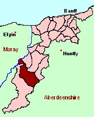
- The small location plan at the head of this page is based on an 1845 map included in the Banffshire volume of the New Statistical Account of Scotland. View a fully-detailed version of this map.
You can see maps centred on OS grid reference NJ231292 (Lat/Lon: 57.346668, -3.279859), Inveravon which are provided by:
- OpenStreetMap
- Google Maps
- StreetMap (Current Ordnance Survey maps)
- Bing (was Multimap)
- Old Maps Online
- National Library of Scotland (Old Ordnance Survey maps)
- Vision of Britain (Click "Historical units & statistics" for administrative areas.)
- Magic (Geographic information) (Click + on map if it doesn't show)
- GeoHack (Links to on-line maps and location specific services.)
- All places within the same township/parish shown on an Openstreetmap map.
- Nearby townships/parishes shown on an Openstreetmap map.
- Nearby places shown on an Openstreetmap map.
Achdregnie, Achnascraw, Aldich, Allanreid, Auchavaich, Auchbreck, Auchnarrow, Auchorachan, Avon, Badievochel, Ballindalloch, Balnafuaran, Bellehiglash, Belnoe, Blairfindy, Bluefolds, Bochet, Bodach, Bogarrow, Bolldow, Bolletten, Braeval, Burnside, Cairnacay, Calier, Castleton, Castletown, Chapeltown, Claggan, Clashnoir, Cordregnie, Corries, Corrunich, Corry, Corshelloch, Coul, Craggan, Craighead, Craigroy, Croftbain, Culantuim, Culquaich, Culraggie, Dalmenach, Dalnashaugh, Dalrachie, Delchirach, Delgarvon, Delhandy, Demickmore, Derrylane, Deskie, Downan, Drum, Drumagrain, Drumin, Dualts, Eastertown, Eskemore, Eskemulloch, Faemore, Gallowhill, Garline, Georgetown, Glack, Glendalloch, Glenlivet, Hillhead, Inveravon, Inverblye, Kilnmaichlie, Knockandhu, Knocknashaig, Knowhead, Kymah, Ladder, Lagavaich, Laggan, Lagmore, Lagual, Lapprach, Larryvarry, Letterach, Lettoch, Livet, Lynebeg, Lynerlach, Marionburgh, Marypark, Morinsh, Mulgainich, Mullochard, Nethertown, Nevie, Norlynn, Ordhead, Parkhead, Peterfair, Phones, Quirn, Refreish, Rhindhu, Scalan, Shenval, Shoulder, Slack, Slateford, Suie, Tervieside, Thain, Tom An Ime, Tomachar, Tomalienan, Tombae, Tombreck, Tombreckachie, Tomfarclas, Tommore, Tomnabrilach, Tomnaglein, Tomnareave, Tomnavoulin, Tomnrieve, Tullich, Weiroch, Westertown, Whitefolds, Woodend
Under the "Poor Law Amendment Act, Scotland" (1845) responsibility for Poor Relief was taken from the Parishes of the Kirk of Scotland, and vested in new Parochial Boards, whose territories largely coincided with the old parishes. The Parochial Boards were not (as in England) grouped into Poor Law Unions, and there were few Poorhouses outside the cities and large towns.
Day-to-day administration of the Poor Law was in the hands of the Inspector of the Poor for each parish, and these Inspectors were obliged by law to maintain detailed records of applications and of relief supplied. The most valuable of these are the "Record of Applications" and the "General Register of the Poor". The "Minutes" are very variable, but on occasion can also contain information on named individuals.
The following Poor Law records have survived for the Parish of Inveravon:
- *General Register of the Poor: 1845 -1915 (BC 6/14/9); 1916 -1931 (BC 6/14/10)
These are held by Aberdeen City Archives. The records are available for viewing, subject to the 100-year rule.
Items marked * are included in a name index compiled by Aberdeen And North-East Scotland FHS (ANESFHS), and held by both ANESFHS and Aberdeen City Archives.
- according to New Statistical Account:
Year 1755 1766 1779 1801 1821 1831 1836 Population 2464 2200 2244 2260 2492 2648 2707 - according to Ordnance Gazetteer of Scotland (1895):
Year 1801 1831 1861 1871 1881 1891 Population 2107 2648 2639 2608 2568 2319
You can also see Family History Societies covering the nearby area, plotted on a map. This facility is being developed, and is awaiting societies to enter information about the places they cover.