
Hide
Olrig, Church of Scotland
hide
Hide
Hide
Church of Scotland,
Main Street,
Castletown,
Olrig
Hide
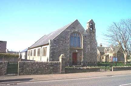
This village church was originally a United Free Church, but is now Church of Scotland. The church has an attached hall or school room, separated by a folding partition. There is a bellcote to the west side of the front. It was built for the United Free Church after 1906, and then became Olrig West Church, before becoming the parish church. The building dates from 1913.
It is located at ND1911868113 (Lat/Lon 58.593435, -3.393173). You can see this on maps provided by:
- OpenStreetMap
- Google Maps
- StreetMap (Current Ordnance Survey maps)
- Bing (was Multimap)
- Old Maps Online
- National Library of Scotland (Old Ordnance Survey maps)
- Vision of Britain (Click "Historical units & statistics" for administrative areas.)
- Magic (Geographic information) (Click + on map if it doesn't show)
- GeoHack (Links to on-line maps and location specific services.)