
Hide
Llanddewi
hide
Hide
hide
Hide
hide
Hide
Hide
"LLAN DDEWI, in the Cwmwd of Gwyr, Cantref of Eginog (now called the Hundred of Swansea), County of GLAMORGAN, South Wales: a discharged Vicarage valued in the King's Books at £3..3..4: Patron, The Bishop of St. David's: Church dedicated to St. David. The Resident Population of this Parish, in 1801, was 126. The Money raised by the Parish Rates, in 1803, was £36..17..2 1/2, at 3s. 6d. in the pound. It is 13 m. S W. b. W. from Swansea. According to the Diocesan Report, in 1809, the yearly value of this Benefice, arising from Augmentation, Tythes, and Surplice fees, was £55..5..0. The Lord Bishop of St. David's is the Impropriator. This Parish contains about 1200 acres of Land, chiefly inclosed." From: A Topographical Dictionary of The Dominion of Wales by Nicholas Carlisle, London, 1811.
"LLANDDEWI, or LLANDEWY, a parish in the hundred of SWANSEA, county of GLAMORGAN, SOUTH WALES, 14 miles (W. by S.) from Swansea, containing 150 inhabitants. A castle is said to have been anciently erected here, the reputed site of which is now occupied by a farm-house, in which some of the walls of the ancient building are reported to be incorporated : there are, however, no records either of the origin or history of the fortress. The living is a discharged vicarage, in the archdeaconry of Carmarthen, and diocese of St. David's, rated in the king's books at £3.3.4., endowed with £800 royal bounty, and in the patronage of the Bishop of St. David's, who is also impropriator of the tithes. The church, dedicated to St. David, is a small edifice. The parishioners of Knelston perform their various religious duties and ceremonies at this church, their own being in a state of dilapidation; and the vicar receives a small additional stipend from the chapter of St. David's, as a compensation for the additional duty. The average annual expenditure for the support of the poor amounts to £29. 18." ( A Topographical Dictionary of Wales by Samuel Lewis 1833)
Hide
Here is a substantial reading list of books which relate to Glamorgan, either county or parish.
The Glamorgan Family History Society have produced a set of microfiche containing Monumental Inscriptions for the following burial grounds :-
- Parish Church of St. David
| St David, Llanddewi |
Glamorgan Chapels Database - no non-conformist chapels were found in this parish
For full and up-to-date details of their holdings see the sites of Glamorgan Record Office and/or West Glamorgan Archives
See Bap/Mar/Bur data on FreeReg
The church is dedicated to St. David, is in the Benefice of Port Eynon with Rhosili with Llanddewi with Knelston and in the diocese of Swansea and Brecon. Details of the present incumbent of this benefice can be found at the Church in Wales website. The church can be located at grid reference SS460891.
| Anglican Parish Registers Held at the Glamorgan Record Office, Cardiff | ||||
| Baptisms | Marriages | Burials | Banns | Bishops Transcripts |
| 1813-1978 | 1813-1970 | 1813-1976 | - | 1678, 1684, 1686, 1697, 1702, 1704, 1707, 1710, 1712, 1717, 1725, 1727-1731, 1733-1736, 1738-1739, 1741-1800, 1802-1803, 1805-1806, 1808-1831, 1833-1848, 1850-1862, 1864-1883 (At the National Library of Wales, Aberystwyth) |
Details of extant records on Archives Network Wales for the following;
- Llanddewi ecclesiastical parish records " Registers (including service and banns registers) 1718-1978; Churchwardens' accounts 1834-1896; electoral roll 1920-1959; faculties and licences 1754-1886; tithe rentcharge 1913-1914; visitors' book 1968-1974."
The following Religious Institutions are covered in the Mormon International Genealogical Index (IGI) :-
- Llanddewi with Knelston, St. David - Christenings (BT's), 1814-1875
Transcript of complete name listing for the Gower parishes, from Slaters Directory for 1880.
The transcription of the section for Llanddewi from The National Gazetteer (1868) provided by Colin Hinson.
- Ask for a calculation of the distance from Llanddewi to another place.
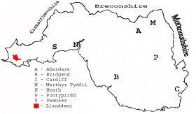
This diagram shows the position of this parish within the county of Glamorgan - click on this to see a full size diagram of the county
|
Parish map (Kain/Oliver)
You can see maps centred on OS grid reference SS453887 (Lat/Lon: 51.576054, -4.234414), Llanddewi which are provided by:
- OpenStreetMap
- Google Maps
- StreetMap (Current Ordnance Survey maps)
- OpenStreetMap Cymru (Welsh counties only)
- Bing (was Multimap)
- Old Maps Online
- National Library of Scotland (Old Ordnance Survey maps)
- Vision of Britain (Click "Historical units & statistics" for administrative areas.)
- Magic (Geographic information) (Click + on map if it doesn't show)
- GeoHack (Links to on-line maps and location specific services.)
- All places within the same township/parish shown on an Openstreetmap map.
- Nearby townships/parishes shown on an Openstreetmap map.
- Nearby places shown on an Openstreetmap map.
Places, villages, farms etc within Llanddewi parish as shown on the online parish map from the CD of Historic Parishes of England and Wales: an Electronic Map of Boundaries before 1850 with a Gazetteer and Metadata [computer file]. (Kain, R.J.P., Oliver, R.R.). (Extracted by Mary Greatorex)
- Llanddewi (35): Berry, Betlands, Castle, Cathan, Henllys, Kingshall, Llanddewi, Monksland, Pilton Green, Scurlage Castle.
The Population of Llanddewi was as follows, and a more detailed breakdown is available.
| 1841 - 164 | 1851 - 174 | 1861 - 149 | 1871 - 141 | 1881 - 108 | 1891 - 119 |
Details of extant records on Archives Network Wales for the following;
- Llanddewi tithe plan and apportionment "Tithe plan and apportionment of Llanddewi, 1841."