
Hide
Oxwich
hide
Hide
hide
Hide
hide
Hide
Hide
"A village in the south of Gower, on the shores of a large and beautiful bay. The church is interesting, and on the headland are the ruins of a castle." [Glamorganshire, 1911]
"OXWICH, (or Oxwick), a parish in the hundred of Swansea, county Glamorgan, 11 miles S.W. of Swansea, its post town, and 2 from Penrice. The village, which is of small extent, is situated in Gower under Cefn-Bryn........(more below) The National Gazetteer of Great Britain and Ireland 1868 by Colin Hinson ©2018
Hide
Here is a substantial reading list of books which relate to Glamorgan, either county or parish.
References to the parish of Oxwich at the British Library
The Glamorgan Family History Society have produced a set of microfiche containing Monumental Inscriptions for the following burial grounds :-
- Parish Church of St. Illtyd
| St Illtyd, Oxwich |
Chapels Database - a list of all known non-conformist chapels or other non-Anglican religions in the parish
See Welsh Chapels and Churches for a photograph
Oxwich Church. Also showing the ruins of the Old Rectory. John Dillwyn Llewelyn (1810-1882) - on the People's Collection Wales site
For full and up-to-date details of their holdings see the sites of Glamorgan Record Office and/or West Glamorgan Archives
See Bap/Mar/Bur data on FreeReg
The church is dedicated to St. Illtyd, is in the Benefice of Oxwich with Penmaen with Nicholaston, and diocese of Swansea and Brecon. Details of the present incumbent of this benefice can be found at the Church in Wales website. The church can be located at grid reference SS505861.
| Anglican Parish Registers Held at the Glamorgan Record Office, Cardiff | ||||
| Baptisms | Marriages | Burials | Banns | Bishops Transcripts |
| 1772-1983 | 1777-1970 | 1772-1984 | 1824-1970 | 1671-1672, 1677-1679, 1681-1684, 1686-1687, 1690-1691, 1696, 1701, 1704, 1707-1708, 1710, 1713-1716, 1723, 1725, 1727-1731, 1735-1767, 1769-1771, 1773-1793, 1795-1796, 1798-1800, 1802-1803, 1805-1841, 1843-1844, 1847-1879, 1881-1882, 1885, 1887-1896, 1898-1899 (All held at the National Library of Wales, Aberystwyth) |
Details of extant records on Archives Network Wales for the following;
- Oxwich Ecclesiastical Parish Records "Registers (including service and banns registers) 1772-1984; miscellaneous 1833-post 1884"
| Non Conformist Registers Held at the West Glamorgan Record Office, Swansea | ||||
| Chapel | Baptisms | Marriages | Burials | OS Map Ref |
| Oxwich Green, Wesleyan | 1864-1913 | - | - | SS 49448606 |
The following Religious Institutions are covered in the Mormon International Genealogical Index (IGI) :-
- Oxwich, St. Illtyd - Christenings (BT's), 1813-1875
Transcript of complete name listing for the Gower parishes, from Slaters Directory for 1880.
The transcription of the section for Oxwich from The National Gazetteer (1868) provided by Colin Hinson.
Descriptions of parish from
A Topographical Dictionary of Wales (1833) by Samuel Lewis
A Topographical Dictionary of The Dominion of Wales by Nicholas Carlisle, London, 1811.
- Ask for a calculation of the distance from Oxwich to another place.
Some of the hamlets, towns and villages within this parish
|
|
Description & Illustrations of Oxwich Castle at www.castlewales.com by Jeff Thomas
Oxwich Castle, north view (1855-1860). Print created in 1934 from Francis Lockey's calotype negative.- on the People's Collection Wales site
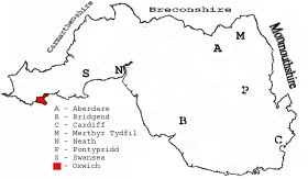
This diagram shows the position of this parish within the county of Glamorgan - click on this to see a full size diagram of the county
|
Tithe map of Oxwich, Glamorgan - on the People's Collection Wales site
Parish map (Kain/Oliver)
You can see maps centred on OS grid reference SS497863 (Lat/Lon: 51.55522, -4.169312), Oxwich which are provided by:
- OpenStreetMap
- Google Maps
- StreetMap (Current Ordnance Survey maps)
- OpenStreetMap Cymru (Welsh counties only)
- Bing (was Multimap)
- Old Maps Online
- National Library of Scotland (Old Ordnance Survey maps)
- Vision of Britain (Click "Historical units & statistics" for administrative areas.)
- Magic (Geographic information) (Click + on map if it doesn't show)
- GeoHack (Links to on-line maps and location specific services.)
- All places within the same township/parish shown on an Openstreetmap map.
- Nearby townships/parishes shown on an Openstreetmap map.
- Nearby places shown on an Openstreetmap map.
During World War I, the body of an unknown and unnamed Royal Navy sailor was washed up on the beach close to Oxwich on the Gower peninsular, a little outside Swansea. He was laid to rest at St. Illtyd's church at Oxwich.
The inscription reads 'A Sailor Of The Great War, Royal Navy, 1st February 1916. Known Unto God'. - on the People's Collection Wales site
Places, villages, farms etc within Oxwich parish as shown on the online parish map from the CD of Historic Parishes of England and Wales: an Electronic Map of Boundaries before 1850 with a Gazetteer and Metadata [computer file]. (Kain, R.J.P., Oliver, R.R.). (Extracted by Mary Greatorex)
- Oxwich (39): Camp, Castle, Coastguard Station, Eastern Slade, Hangman Cross, Holy Wash, Norton, Oxwich, Oxwich Burrows, Oxwichgreen, Oxwich Point, The Cove, The Sands, Western Slade.
- Collins family of Oxwich
1430-c1800: deeds, family and estate papers
[University of Swansea Library]
The Population of Oxwich was as follows, and a more detailed breakdown is available.
| 1841 - 345 | 1851 - 369 | 1861 - 328 | 1871 - 255 | 1881 - 229 | 1891 - 214 |
Details of extant records on Archives Network Wales for the following;
- Oxwich Parish Council records "................ including minutes, 1894-1973; rate book, 1887-1888; financial records, 1951-1956; photocopy of tithe plan 1844, [late 20th century]."
The School, Oxwich - on People's Collection Wales (use search box)
Details of extant records on Archives Network Wales for the following;
- Oxwich School Records " ........ including log books, 1884-1961; class registers, 1882-1884; financial records, 1949-1960; correspondence, c.1895-1961."
The School, Oxwich - on the People's Collection Wales site