
Hide
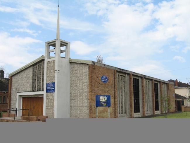
St Chad, Leasowe, Church of England
hide
Hide
Hide
St Chad,
Twickenham Drive,
Leasowe
Hide
It was founded in 1955.
Twickenham Drive.
Church History
In 1957 became the district church for parts of Bidston, Hoylake, Moreton and Wallasey (previously served by Bidston: St. Oswald, Great Meols: St. John the Baptist, Moreton: Christ Church, Wallasey: St. Hilary and Wallasey: St. Nicholas). The boundaries of "The District (or Parish) of Saint Chad, Leasowe", were described in the London Gazette on 29 November 1957:
"1. All those contiguous parts of the parishes of Christ Church, Moreton, and Saint John the Baptist, Great Meols, which lie to the north and east of an imaginary line commencing at a point on the boundary which divides the parish of Christ Church, Moreton, from the parish of Bidston in the middle of the brook or stream known as The Birket and proceeding thence generally westwards along the middle of The Birket to a point in the middle of the culvert which carries The Birket under Pasture Road and continuing thence northwestwards along the middle of Pasture Road to its end at Wallasey Embankment and continuing thence northwestwards in the same straight line across Wallasey Embankment to the sea."
"2. All those contiguous parts of the parishes of Bidston, Wallasey and Saint Nicholas, Wallasey, which lie to the north and west of an imaginary line commencing at a point on the boundary which divides the parish of Christ Church, Moreton, from the parish of Bidston in the middle of the brook or stream known as The Birket and proceeding thence eastwards along the middle of The Birket to the point at the southeastern corner of close numbered 6815 (on the map) where The Birket is joined by the unnamed brook or stream which divides closes numbered 2031 and 8908 from closes numbered 1576, 0648, 7840 and 6815 and continuing thence northeastwards to and along the middle of the last mentioned brook or stream to a point opposite the southern end of the western boundary of close numbered 3680 and continuing thence northwestwards across close numbered 15716 to and along the last mentioned boundary to the point at which it is crossed by the middle of the footpath which leads southeastwards from Leasowe Road to the Pumping Station situate in close numbered 157'6 and continuing thence northwestwards along the middle of the said footpath to its end and in a straight line in continuation thereof to a point on the boundary which divides the parish of Wallasey from the parish of Saint Nicholas, Wallasey, in the middle of Leasowe Road and. continuing thence southwestwards along the last mentioned boundary to a point opposite the middle of the southeastern end of Telegraph Lane and continuing thence northwestwards to and along the middle of Telegraph Lane to its end at Green Lane and continuing thence northwestwards across Green (Lane to the middle of the southeastern end of 'the footpath which leads northwestwards from Green Lane across the Wallasey Golf Links to the Promenade and continuing thence northwestwards along the middle of the last mentioned footpath to its end and continuing thence northwestwards in the same straight line across the Promenade to the sea."
Church Records
C = Christenings (Baptisms) ; M = Marriages ; B = Burials ; BTs = Bishop's Transcripts
| Original Registers | C from 1955 ; M from 1958 — Church |
| Notes | B — none |
- OpenStreetMap
- Google Maps
- StreetMap (Current Ordnance Survey maps)
- Bing (was Multimap)
- Old Maps Online
- National Library of Scotland (Old Ordnance Survey maps)
- Vision of Britain (Click "Historical units & statistics" for administrative areas.)
- English Jurisdictions in 1851 (Unfortunately the LDS have removed the facility to enable us to specify a starting location, you will need to search yourself on their map.)
- Magic (Geographic information) (Click + on map if it doesn't show)
- GeoHack (Links to on-line maps and location specific services.)