
Hide
Bolton
hide
Hide
There is more than one Bolton in Lancashire. This is the main one, nowadays just referred to as Bolton, and was also known as Bolton-le-Moors.
Hide
hide
Hide
hide
Hide
Hide
BOLTON-LE-MOORS, a parish in the districts of Bolton, Wigan, and Chorley, Lancashire. It centres in the Post Town of Bolton; and contains the townships of Great Bolton, Little Bolton, Sharples, Quarlton, Edgeworth, Entwistle, Longworth, Turton, Bradshaw, Haulgh, Tonge, Breightmet, Harwood, Lostock, Darcy-Lever, Blackrod, Anglezarke, and Rivington, and the chapelry of Little Lever. Acres, 30,062. Real property, £332,547; of which £29,356 are in mines, and £1,969 in quarries. Pop. in 1841, 73,905; in 1861, 97,215. Houses, 18,385. The living is a vicarage in the diocese of Manchester. Value, £350.* Patron, the Bishop of Manchester. The vicarages of Holy Trinity, St. George, Christ Church, and St. John, and the p. curacies of All Saints, Emmanuel, St. Mark, and St. Paul, within the borough of Bolton, are separate benefices. Value of Holy Trinity, St. George, Christ Church, and St. John, each £300; of Emmanuel, £300;* of St. Mark, £160; of St. Paul, £150; of All Saints, £128. Patron of H. T., the Bishop of Manchester; of St. G. and E., the Vicar of Bolton; and of St. J., alternately the Crown and the Bishop; of A. S., T. Tipping, Esq.; of St. M. and St. P., Trustees. The vicarages of Astley-Bridge, Belmont, Blackrod, Bradshaw, Little Lever, and Lever Bridge, and the p. curacies of Harwood, Rivington, Tonge, Turton, and Walmsley also are separate benefices. See the articles on these places and Bolton.
John Marius Wilson, Imperial Gazetteer of England and Wales (1870-72)
Hide
Local Studies,
Central Library,
Le Mans Crescent,
BOLTON BL1 ISE
Tel: 01204 332185 Fax: 01204 363224
| Moor Lane, Bolton, Baptist |
| Albert Place, Bolton, Independent |
| Cemetery, Bolton, Society of Friends |
| Folds Rd Independent Methodist, Bolton |
| Hanover St, Bolton, Wesleyan Refuge |
| Ridgeway Gates, Bolton, Wesleyan Methodist |
| St George's Rd, Bolton, Wesleyan Methodist |
| Bank St Unitarian, Bolton |
| Moor Lane, Bolton, Unitarian |
| St Peter and St Paul Roman Catholic, Bolton |
| Tipping St, Bolton, Society of Friends |
Details about the census records, and indexes for Bolton.
A considerable number of church records have been published by the Bolton branch of the Manchester & Lancashire FHS.
The Register Office covering the Bolton area is Bolton.
Bolton Metropolitan Borough Council provide a range of information about the town.
The Bolton website has a range of pictures and information about the town.
"THE OAKS, a railway station on the western section of the Lancashire and Yorkshire line. It is the first station after leaving Bolton."
- Ask for a calculation of the distance from Bolton to another place.
In 1835 the parish of Bolton contained the townships of Great Bolton, Blackrod, Lostock, Anglezarke, Rivington, Sharples, Longworth, Turton, Bradshaw, Entwistle, Edgworth, Quarlton, Harwood, Musbury, Breightmet, Little Bolton, Tonge and Haulge, Darcy Lever and Little Lever.
The history of Bolton from Pigot's Lancashire directory, 1830.
Some more information about the history of Bolton.
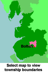
View maps of Bolton and places within its boundaries.
View a map of the boundaries of this town/parish.
You can see maps centred on OS grid reference SD714083 (Lat/Lon: 53.570822, -2.432828), Bolton which are provided by:
- OpenStreetMap
- Google Maps
- StreetMap (Current Ordnance Survey maps)
- Bing (was Multimap)
- Old Maps Online
- National Library of Scotland (Old Ordnance Survey maps)
- Vision of Britain (Click "Historical units & statistics" for administrative areas.)
- English Jurisdictions in 1851 (Unfortunately the LDS have removed the facility to enable us to specify a starting location, you will need to search yourself on their map.)
- Magic (Geographic information) (Click + on map if it doesn't show)
- GeoHack (Links to on-line maps and location specific services.)
- All places within the same township/parish shown on an Openstreetmap map.
- Nearby townships/parishes shown on an Openstreetmap map.
- Nearby places shown on an Openstreetmap map.
The Workhouse site has an interesting description of Bolton workhouse.
For probate purposes prior to 1858, Bolton was in the Archdeaconry of Chester, in the Diocese of Chester. The original Lancashire wills for the Archdeaconry of Chester are held at the Lancashire Record Office.
Bolton and District Family History Society, is a branch of the Manchester & Lancashire FHS.
You can also see Family History Societies covering the nearby area, plotted on a map. This facility is being developed, and is awaiting societies to enter information about the places they cover.