
Hide
Society of Friends, Colthouse
hide
Hide


Hide
Hide
The meeting house has a graveyard. Seventeen of the earliest memorials were recorded in 1892 by Henry Swainson Cowper in his short book "The Monumental Inscriptions in the parish church and churchyard of Hawkshead, Lancashire and in the burial grounds of Satterthwaite, the Baptists at Hawkshead Hill and the Quakers at Colthouse".
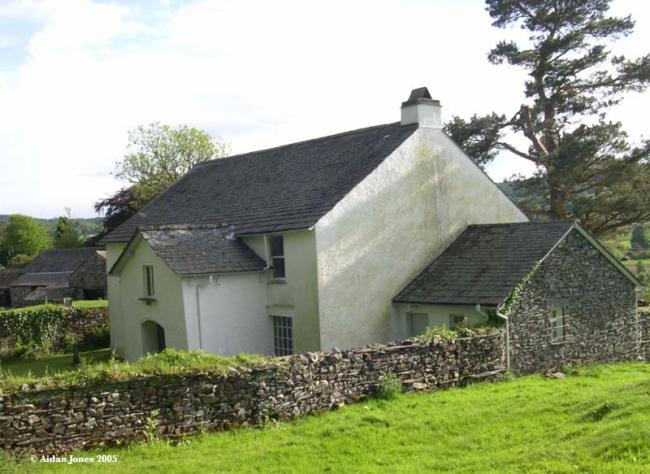
It was founded before 1658. The building dates from 1688. The nearby graveyard (which has stone seating in the walls) was acquired in 1669.
Whilst every effort has been made to record exact details of record office and library holdings
you are recommended to check with them before visiting to ensure that they do hold the records and years you
wish to examine. Similarly check with transcript publishers to ensure they cover the records and years
you require before making a purchase.
Copies of Original Registers
Baptisms
- 1652-1784 held by Lancashire Record Office MF 1/48 - Microfilm
- 1652-1784 held by Lancashire Record Office MF 1/48 - Microfilm
Marriages
- 1659-1776 held by Lancashire Record Office MF 1/48 - Microfilm
- 1659-1776 held by Lancashire Record Office MF 1/48 - Microfilm
Burials
- 1656-1784 held by Lancashire Record Office MF 1/48 - Microfilm
- 1656-1784 held by Lancashire Record Office MF 1/48 - Microfilm
- 1658-1910 held by Lancashire Record Office Searchroom - Printed
- 1658-1910 held by Lancashire Record Office Searchroom - Printed
Copies of Bishop's Transcripts
Burials
- 1865-1894 held by Lancashire Record Office DRC 2/38 - Microfilm
- 1865-1894 held by Lancashire Record Office DRC 2/38 - Microfilm
Register Transcripts
MI
- 1859-1889 held by Lancashire Record Office Searchroom - Printed
- 1859-1889 held by Lancashire Record Office Searchroom - Printed
Whilst every effort has been made to record exact details of record office and library holdings
you are recommended to check with them before visiting to ensure that they do hold the records and years you
wish to examine. Similarly check with transcript publishers to ensure they cover the records and years
you require before making a purchase.
Original registers
Early registers in National Archives, London (microfilm copies at Cumbria Record Office, Barrow). They predate the building of the meeting house. Further records, including early minute books, at the Cumbria Record Office, Barrow:- Births 1652-1784
- Marriages 1656-1784
- Burials 1656-1784, 1658-1955
It is located at SD3587698184 (Lat/Lon 54.375105, -2.98864). You can see this on maps provided by:
- OpenStreetMap
- Google Maps
- StreetMap (Current Ordnance Survey maps)
- Bing (was Multimap)
- Old Maps Online
- National Library of Scotland (Old Ordnance Survey maps)
- Vision of Britain (Click "Historical units & statistics" for administrative areas.)
- English Jurisdictions in 1851 (Unfortunately the LDS have removed the facility to enable us to specify a starting location, you will need to search yourself on their map.)
- Magic (Geographic information) (Click + on map if it doesn't show)
- GeoHack (Links to on-line maps and location specific services.)