
Hide
Droylsden
hide
Hide
hide
Hide
hide
Hide
Hide
"DROYLSDEN, a township-chapelry in Manchester parish, Lancashire; on the Rochdale canal and the Manchester and Sheffield railway, 4 miles E of Manchester. It includes the hamlet of Little Droylsden, and the villages of Fairfield and Clayton; and it has a station on the railway, and a post office under Manchester. Acres, 1,611. Real property, £25,121. Pop., 8,798. Houses, 1,718. The property is subdivided. Many of the inhabitants are employed in cotton factories. The living is a rectory in the diocese of Manchester. Value, £130. Patron, alternately the Crown and the Bishop. The church was built in 1848; an Independent chapel, in 1860; a Wesleyan chapel, in 1866; and there are Moravian and P. Methodist chapels, and British schools."
John Marius Wilson, Imperial Gazetteer of England and Wales (1870-72)
Hide
Local studies information is held at Tameside local studies library.
Details about the census records, and indexes for Droylesden.
| Ashton Hill Lane Independent, Droylsden |
| Fairfield Road, Droylsden, Congregational |
| Seymour Rd South Congregational, Clayton |
| Manor Rd Cemetery, Droylsden |
The Register Office covering the Droylsden area is Tameside.
The National Gazetteer of Great Britain and Ireland - 1868
"DROYLESDEN, a township in the parish of Manchester, hundred of Salford, in the county palatine of Lancaster, 2 miles W. of Ashton-under-Lyne, and 4 E. of Manchester. It has stations on the Manchester and Leeds section of the London and North-Western, and on the Lancashire and Yorkshire railways. It is situated on the Rochdale canal, and contains the hamlets of Little Droylsden, Fairfield, and Clayton. The inhabitants are, for the most part, employed in the cotton factories. The living is a perpetual curacy in the diocese of Manchester, value £130, in the patronage of the crown and bishop alternately. The Wesleyan Methodists have a place of worship, and there is a Moravian settlement at Fairfield."
"FAIRFIELD, a village in the parish of Manchester, and township of Droylsden, county palatine Lancaster, 4 miles E. of Manchester. The Manchester, Sheffield, and Lincolnshire railway has a station here. The people are employed as cotton spinners. The Moravians have a settlement in this place."
- Ask for a calculation of the distance from Droylsden to another place.
In 1835 Droylsden was a township in the parish of Manchester.
View maps of Droylsden and places within its boundaries.
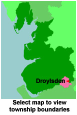
View a map of the boundaries of this town/parish.
You can see maps centred on OS grid reference SJ895985 (Lat/Lon: 53.483464, -2.159206), Droylsden which are provided by:
- OpenStreetMap
- Google Maps
- StreetMap (Current Ordnance Survey maps)
- Bing (was Multimap)
- Old Maps Online
- National Library of Scotland (Old Ordnance Survey maps)
- Vision of Britain (Click "Historical units & statistics" for administrative areas.)
- English Jurisdictions in 1851 (Unfortunately the LDS have removed the facility to enable us to specify a starting location, you will need to search yourself on their map.)
- Magic (Geographic information) (Click + on map if it doesn't show)
- GeoHack (Links to on-line maps and location specific services.)
- All places within the same township/parish shown on an Openstreetmap map.
- Nearby townships/parishes shown on an Openstreetmap map.
- Nearby places shown on an Openstreetmap map.
For probate purposes prior to 1858, Droylsden was in the Archdeaconry of Chester, in the Diocese of Chester. The original Lancashire wills for the Archdeaconry of Chester are held at the Lancashire Record Office.
You can also see Family History Societies covering the nearby area, plotted on a map. This facility is being developed, and is awaiting societies to enter information about the places they cover.