
Hide
Foulridge
hide
Hide
hide
Hide
hide
Hide
Hide
FOULRIDGE, a township in Whalley parish, Lancashire; on the Leeds canal and the Colne and Skipton railway, 2 miles N of Colne. It has a station on the railway, and a post office under Colne. Acres, 2,450. Real property, £4,498; of which £70 are in quarries. Pop. in 1851, 1,233; in 1861, 988. Houses, 203. The decrease of pop. arose from the discontinuance of handloom weaving. There are a Wesleyan chapel and a national school.
John Marius Wilson, Imperial Gazetteer of England and Wales (1870-72)
Hide
Local studies information is held at Colne library.
| Ivegate, Foulridge, Society of Friends |
Details about the census records, and indexes for Foulridge.
| Ivegate, Foulridge, Society of Friends |
The Register Office covering the Foulridge area is Burnley and Pendle.
Local information provided by Pendle.Net.
Transcript of the entry of professions and trades. for FOULRIDGE in The Craven Household Almanack Directory of 1911.
The National Gazetteer of Great Britain and Ireland - 1868
"FOULRIDGE, a township in the parish of Whalley, higher division of the hundred of Blackburn, county palatine Lancaster, 2 miles N. of Colne. It is a station on the Midland railway. The village is pleasantly situated on the Leeds canal. There are stone-quarries extensively worked, and manufactories of cotton goods, affording employment to the people. The Wesleyans have a chapel, and there is a National school in which Divine service is performed on Sunday. The Liverpool and Leeds canal has two large reservoirs here."
- Ask for a calculation of the distance from Foulridge to another place.
In 1835 Foulridge was a township in the parish of Whalley.
Information about boundaries and administrative areas is available from A Vision of Britain through time.
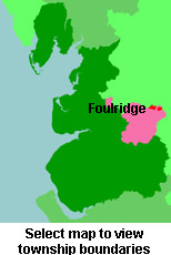
View a map of the boundaries of this town/parish.
You can see maps centred on OS grid reference SD908423 (Lat/Lon: 53.877113, -2.141787), Foulridge which are provided by:
- OpenStreetMap
- Google Maps
- StreetMap (Current Ordnance Survey maps)
- Bing (was Multimap)
- Old Maps Online
- National Library of Scotland (Old Ordnance Survey maps)
- Vision of Britain (Click "Historical units & statistics" for administrative areas.)
- English Jurisdictions in 1851 (Unfortunately the LDS have removed the facility to enable us to specify a starting location, you will need to search yourself on their map.)
- Magic (Geographic information) (Click + on map if it doesn't show)
- GeoHack (Links to on-line maps and location specific services.)
- All places within the same township/parish shown on an Openstreetmap map.
- Nearby townships/parishes shown on an Openstreetmap map.
- Nearby places shown on an Openstreetmap map.
For probate purposes prior to 1858, Foulridge was in the Archdeaconry of Chester, in the Diocese of Chester. The original Lancashire wills for the Archdeaconry of Chester are held at the Lancashire Record Office.
You can also see Family History Societies covering the nearby area, plotted on a map. This facility is being developed, and is awaiting societies to enter information about the places they cover.