
Hide
Newton Heath
hide
Hide
hide
Hide
hide
Hide
Hide
Newton Heath is a township and ecclesiastical parish, within the parish and parliamentary borough, but not within the municipal boundary of Manchester, situated a mile and a half to the east of that city, in the union of Prestwich, and county court district of Manchester, rural deanery of Cheetham, and archdeaconry and diocese of Manchester.
from Kelly's Manchester Directory, 1873
Hide
Local studies information is held at Manchester central library.
Details about the census records, and indexes for Newton Heath.
The Register Office covering the Newton Heath area is Manchester.
The National Gazetteer of Great Britain and Ireland - 1868
"NEWTON HEATH, a hamlet in the township of Newton, and parish of Manchester, hundred of Salford, county Lancaster, 3 miles N.E. of Manchester. It is a station on the eastern section of the Lancashire and Yorkshire railway."
"NEWTON, a township and ecclesiastical district in the parish of Manchester, hundred of Salford, county Lancaster, 2 miles N.E. of Manchester, within which borough it is included. The village, which is very considerable, forms a populous suburb of Manchester. The manufactures of cotton and silk, and the printing of calico are extensively carried on. The living is a rectory in the diocese of Manchester, value £155, in the patronage of the dean and chapter. The church, dedicated to All Saints, was rebuilt on the site of an ancient chapel at an expense of £8,000. There are places of worship for Wesleyans, Unitarians, Society of Friends, and other Dissenting communions; also National and other schools. See Manchester."
"MILES-PLATTING, a hamlet in the parish and borough of Manchester, county Lancaster, 1 mile N.E. of Manchester. It is a station on the Leeds railway. The hamlet is situated near Collyhurst Hall."
- Ask for a calculation of the distance from Newton Heath to another place.
In 1835 Newton Heath was a township in the parish of Manchester.
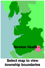
View maps of Newton Heath and places within its boundaries.
View a map of the boundaries of this town/parish.
You can see maps centred on OS grid reference SD874000 (Lat/Lon: 53.49699, -2.190694), Newton Heath which are provided by:
- OpenStreetMap
- Google Maps
- StreetMap (Current Ordnance Survey maps)
- Bing (was Multimap)
- Old Maps Online
- National Library of Scotland (Old Ordnance Survey maps)
- Vision of Britain (Click "Historical units & statistics" for administrative areas.)
- English Jurisdictions in 1851 (Unfortunately the LDS have removed the facility to enable us to specify a starting location, you will need to search yourself on their map.)
- Magic (Geographic information) (Click + on map if it doesn't show)
- GeoHack (Links to on-line maps and location specific services.)
- All places within the same township/parish shown on an Openstreetmap map.
- Nearby townships/parishes shown on an Openstreetmap map.
- Nearby places shown on an Openstreetmap map.
Newton Heath was part of the Prestwich Poor Law Union.
For probate purposes prior to 1858, Newton Heath was in the Archdeaconry of Chester, in the Diocese of Chester. The original Lancashire wills for the Archdeaconry of Chester are held at the Lancashire Record Office.
You can also see Family History Societies covering the nearby area, plotted on a map. This facility is being developed, and is awaiting societies to enter information about the places they cover.