
Hide
Salford
hide
Hide
hide
Hide
hide
Hide
Hide
SALFORD, a town, a township, seven chapelries, a district, and a hundred, in Lancashire. The town stands on the W side of the river Irwell, on the Bolton and Bury canal, and on the Northwestern, the Lancashire and Yorkshire, the East Lancashire, and the South Junction railways, contiguous to Manchester; is separated from that city only by the river Irwell, and communicates with it by numerous bridges; was politically superior to it in the 9th century; became afterwards suburbanto it; is now, in participation of its trade, and for all other practical purposes, an integral part of it; presents a near resemblance to it in streets and edifices; contains several public buildings and a great public park, which belong fully more to Manchester than to itself; has railway stations and numerous institutions of its own, and a post-office, several receiving post-offices, and several postal pillar-boxes under Manchester; publishes a weekly newspaper; and is a parliamentary and municipal borough.and a seat of petty sessions, quarter sessions, county courts, and a court of record. The borough boundaries are the same municipally as parliamentarily; and include all Salford, Pendleton, and Broughton townships, and part of Pendlebury. Amount of property and income tax charged in 1863, £27,220. Electors in 1833, 1,497; in 1863, 5,137. Pop. in 1861, 102,449. Houses, 19,128. The township comprises 1,220 acres. Real property, £199,407. Pop. in 1851, 63,423; in 1861, 71,002. Houses, 13,303. more ...
John Marius Wilson, Imperial Gazetteer of England and Wales (1870-72)
Hide
- Salford Local History Library.
- Working Class Movement Library,
Jubilee House,
51 The Crescent,
SALFORD M5 4WX,
Telephone 0161 736 2649The above Working Class Library is very useful for background details. The first approach should be by telephone.
Agecroft Cemetery
Langley Road
Agecroft
Pendlebury
Lancashire
England
M27 8SS
Tel. 44 (0)161 736 2512 Fax. 44 (0)161 737 5538
They also have information on Weaste Cemetery.
Peel Green Cemetery
716 Liverpool Road
Eccles
Lancashire
England
M30 7LW
They also have information on Swinton Cemetery
| New Windsor, Salford, Independent |
| Irwell St, Salford, Wesleyan Methodist |
| Greengate/Dawson's Croft, Salford, Unitarian |
| St John the Evangelist (Cathedral), Salford, Roman Catholic |
Details about the census records, and indexes for Salford.
Anne Gerhard, has researched some information concerning Early Christian Salford.
Salford Register Office holds records of births, marriages and deaths since 1837.
The National Gazetteer of Great Britain and Ireland - 1868
"SALFORD, a township, market town, municipal and parliamentary borough, having separate jurisdiction, but locally in the parish of Manchester, hundred of Salford, county Lancaster, adjoining Manchester, under which article it has already been described. The borough, as distinguished from Manchester, includes the ecclesiastical districts of Christ Church, St. Bartholomew, St. Matthias, St. Philip, St. Simon, St. Stephen, and Holy Trinity, together containing a population of 102,440, according to the census of 1861. See Manchester."
"CROSS LANE, a hamlet in the borough of Manchester, in the county of Lancaster, 1 mile W. of Manchester. It is a station on the Manchester and Liverpool section of the London and North-Western railway."
- Ask for a calculation of the distance from Salford to another place.
In 1835 Salford was a township in the parish of Manchester.
A description of the of area known as Hanky Park.
How Salford was granted it's charter.
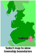
View maps of Salford and places within its boundaries.
View a map of the boundaries of this town/parish.
You can see maps centred on OS grid reference SJ817981 (Lat/Lon: 53.479089, -2.276809), Salford which are provided by:
- OpenStreetMap
- Google Maps
- StreetMap (Current Ordnance Survey maps)
- Bing (was Multimap)
- Old Maps Online
- National Library of Scotland (Old Ordnance Survey maps)
- Vision of Britain (Click "Historical units & statistics" for administrative areas.)
- English Jurisdictions in 1851 (Unfortunately the LDS have removed the facility to enable us to specify a starting location, you will need to search yourself on their map.)
- Magic (Geographic information) (Click + on map if it doesn't show)
- GeoHack (Links to on-line maps and location specific services.)
- All places within the same township/parish shown on an Openstreetmap map.
- Nearby townships/parishes shown on an Openstreetmap map.
- Nearby places shown on an Openstreetmap map.
The Workhouse site has an interesting description of Salford workhouse.
For probate purposes prior to 1858, Salford was in the Archdeaconry of Chester, in the Diocese of Chester. The original Lancashire wills for the Archdeaconry of Chester are held at the Lancashire Record Office.
You can also see Family History Societies covering the nearby area, plotted on a map. This facility is being developed, and is awaiting societies to enter information about the places they cover.