
Hide
Coningsby
hide
Hide
hide
Hide
hide
Hide
Hide
Hide
| Coningsby, Cemetery |
- The parish was in the Tattershall sub-district of the Horncastle Registration District.
- Check our Census Resource page for county-wide resources.
- The table below gives census piece numbers, where known:
| Census Year | Piece No. |
|---|---|
| 1841 | H.O. 107 / 631 |
| 1851 | H.O. 107 / 2108 |
| 1861 | R.G. 9 / 2371 |
| 1871 | R.G. 10 / 3386 |
| 1881 | R.G. 11 / 3252 |
| 1891 | R.G. 12 / 2600 |
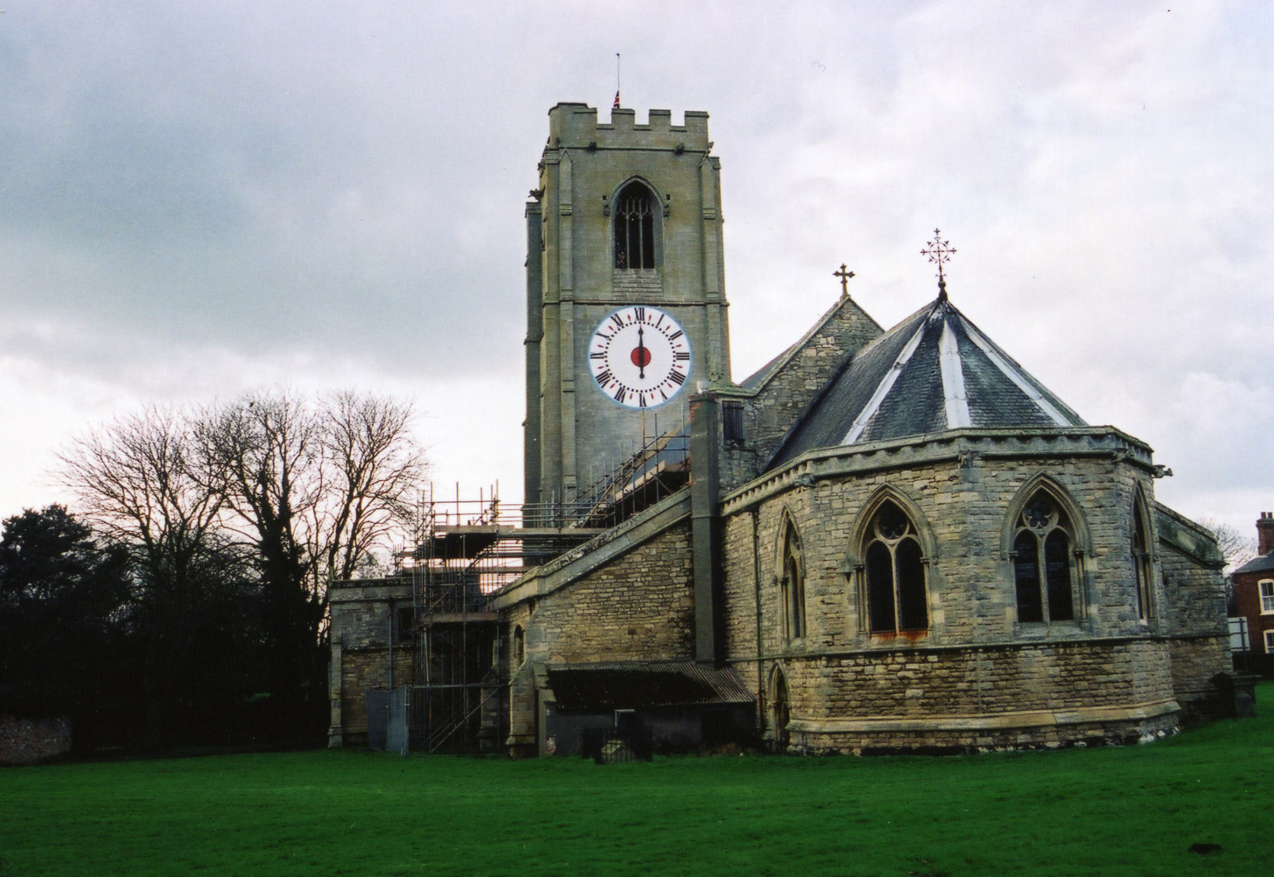
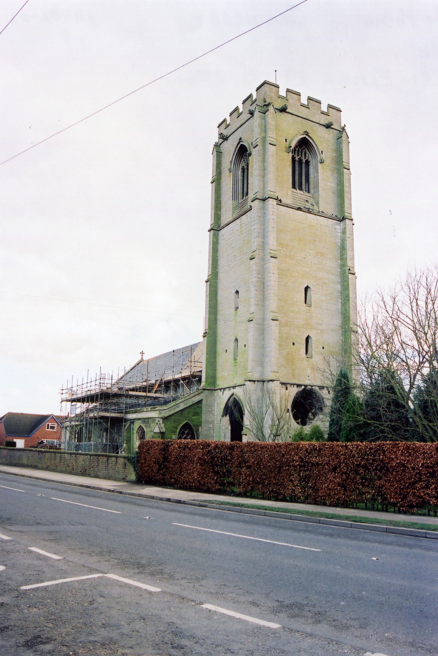
- The Anglican parish church is dedicated to Saint Michael.
- Some portions of the church are of Norman origin.
- The church has a unique one-handed clock dating from the 17th century, over 16 feet in diameter.
- Here are two photos of Saint Michael's Church, taken by Ron COLE (who retains the copyright):
- The LFHS has published several marriage and burial indexes for the Horncastle Deanery to make your search easier. The parish has also been in the Deanery of Gartree (circa 1910).
- We have a partial extract from the parish register in a text file. Your additions are welcome.
- There is an active Baptist Church in the village. The church has its own website. There is no history as yet (early 2015) on the web site, but it is still under development. The original Baptist chapel was built here in 1651.
- The Wesleyan and Primitive Methodists both had chapels in the village. The current Methodists have a chapel here that dates back to before 1870. For information and assistance in researching these chapels, see our non-conformist religions page.
- Check our Church Records page for county-wide resources.
- The parish was in the Tattershall sub-district of the Horncastle Registration District.
- Check our Civil Registration page for sources and background on Civil Registration which began in July, 1837.
Coningsby lies between the Wolds on one side and the Fens on the other, along the banks of the River Bain. It is 8 miles south of Horncastle and twelve miles north-west of Boston. Tattershall parish is to the north-west. The parish covers over 3,600 acres and includes the hamlets of Haven Bank, Reedham and Dogdyke. Reedham is about 4 miles south of the village of Coningsby.
If you are planning a visit:
- Consider staying overnight at the Dower House Hotel in nearby Woodhall Spa, only two miles away.
- Try the Castle Inn at 50 High Street.
- There is an active golf club associated with RAF Coningsby.
- If coming by bus or train, check the Carlberry bus/car service for bus times or car hires.
- Check the East Lindsey Council site for tourism information.
- Visit our touring page for more sources.
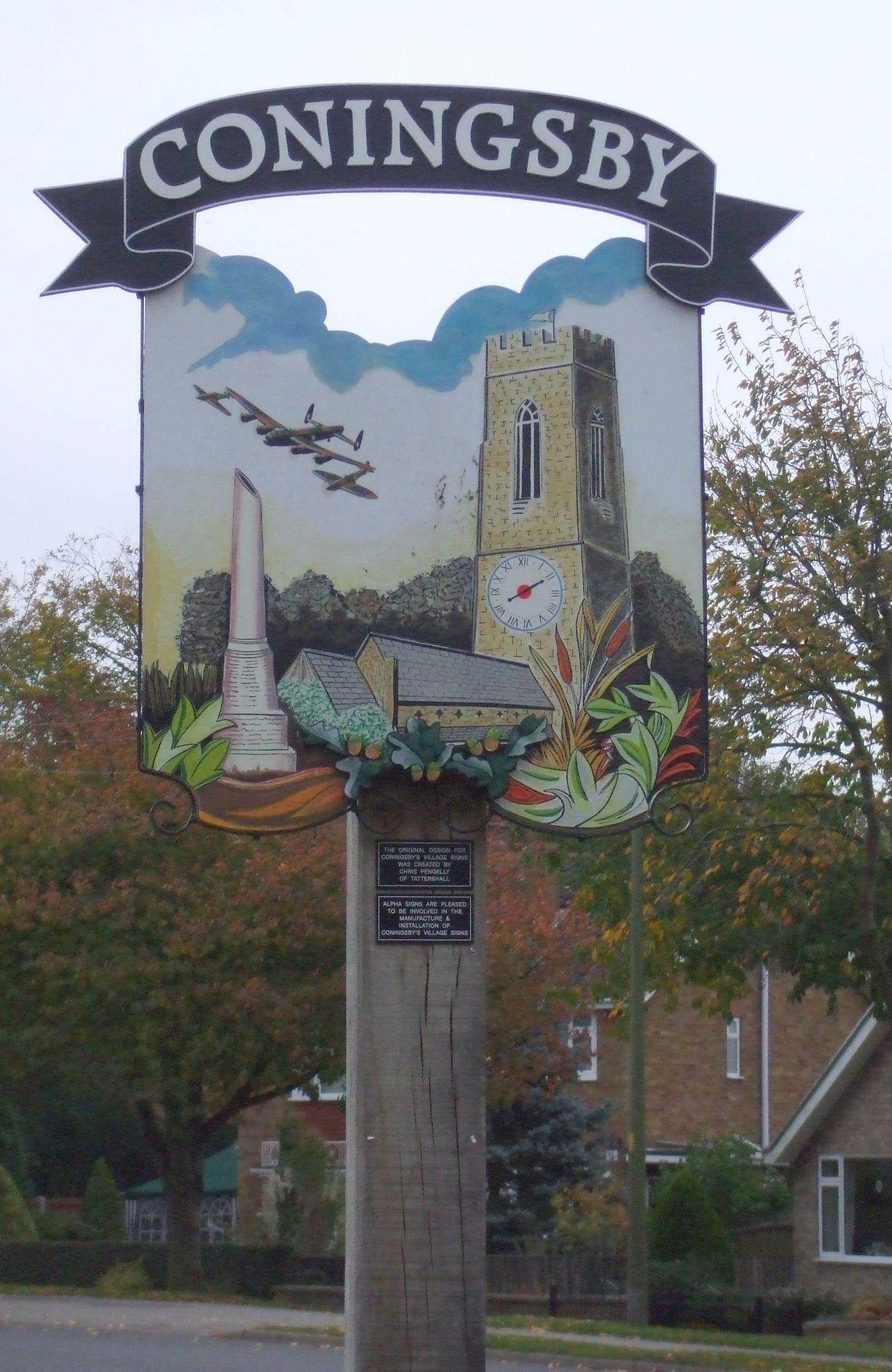
- Patricia McCRORY provides this photograph of the village sign seen when entering the village:
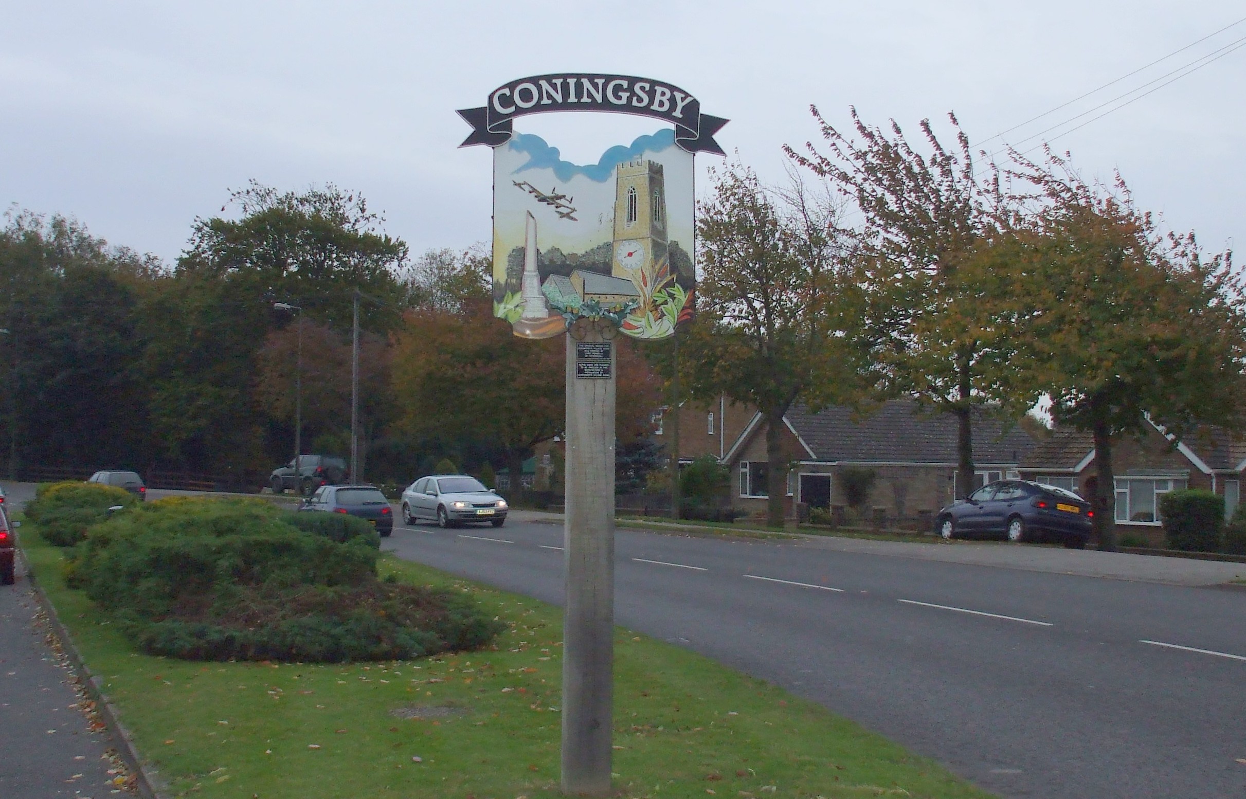
- We do offer these signs, photographed by Partricia McCRORY (who retains the copyright). In the second one, you can see the church tower in the background:
-
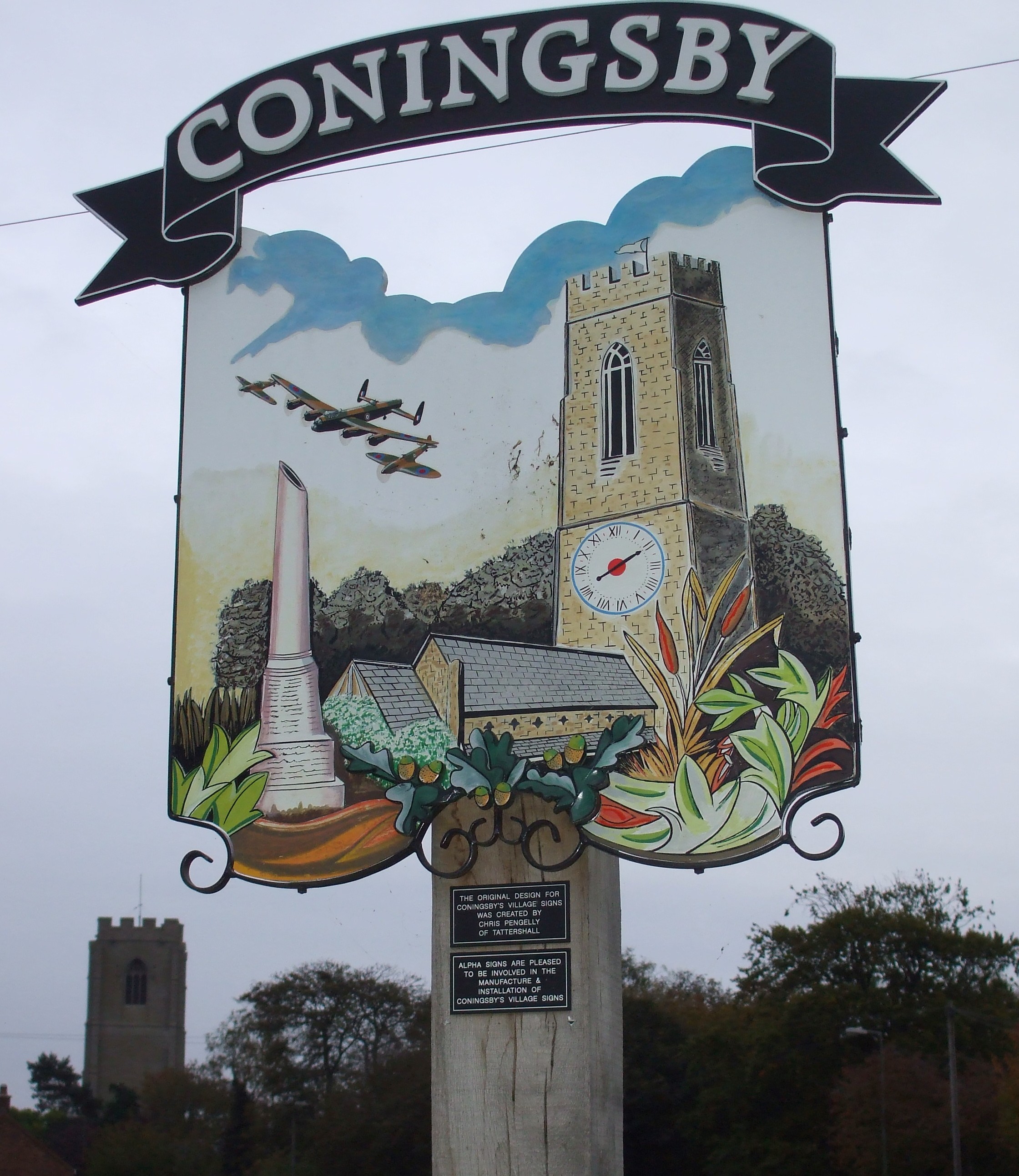
- To see more of the village sign, check out Coningsby Sign.
- Ask for a calculation of the distance from Coningsby to another place.
- Local lore has it that this was a Viking village or settlement.
- There is a saline spring here, called "The Spa".
- In 1861, lighting was brought to the village through a gas works.
- About the same time, the village had a station on the Great Northern Railway line.
- There was a county police station here by 1912. At that time, John W. STEVENSON was the sergeant in charge.
- Coningsby Castle no longer remains. A painting of it existed at Hampton Court in 1882.
- The manor was the former seat of the MARMYON family, then later the seat of the CONINGSBY family.
- See our Maps page for additional resources.
You can see maps centred on OS grid reference TF224581 (Lat/Lon: 53.106392, -0.173206), Coningsby which are provided by:
- OpenStreetMap
- Google Maps
- StreetMap (Current Ordnance Survey maps)
- Bing (was Multimap)
- Old Maps Online
- National Library of Scotland (Old Ordnance Survey maps)
- Vision of Britain (Click "Historical units & statistics" for administrative areas.)
- English Jurisdictions in 1851 (Unfortunately the LDS have removed the facility to enable us to specify a starting location, you will need to search yourself on their map.)
- Magic (Geographic information) (Click + on map if it doesn't show)
- GeoHack (Links to on-line maps and location specific services.)
- All places within the same township/parish shown on an Openstreetmap map.
- Nearby townships/parishes shown on an Openstreetmap map.
- Nearby places shown on an Openstreetmap map.
- The RAF built an airbase here on the southern edge of the village, near the intersection of the A153 and A155 trunk roads. Construction started in 1937 and the field opened on 4 November, 1940 as 5 Group Bomber Command. At first, the landing strips were grass.
- The field was closed for almost a year, from September, 1942, to August, 1943, while hard runways were laid down. Tis would allow heavier aircraft to use the strips and all aircraft to use the strips in wet weather.
- The runways were extended in 1954 - 1956 and resurfaced in 2003.
- This is still an active RAF station (as of 2011).
- There is a memorial to the Battle of Britain, open to the public on weekdays. The military facilities were recently closed for refurbishment.
- The Lincolnshire Film Archive has an 8-minute clip of the RAF unit in 1969 entitled 405 Phantoms at Coningsby.
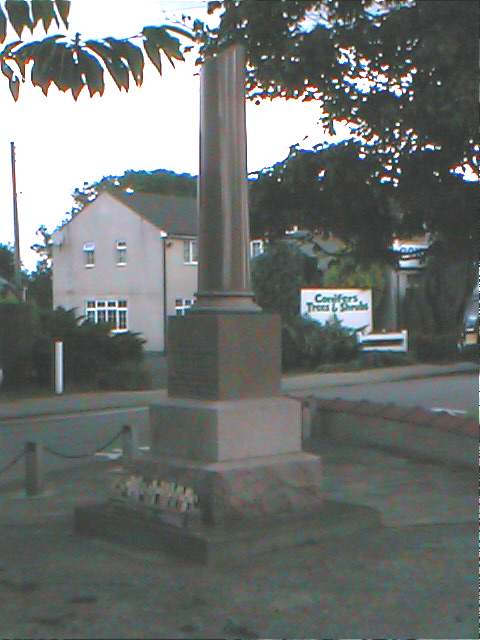
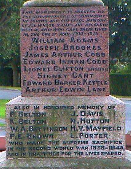
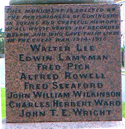
John EMERSON, who retains the copyright, provides these photographs of the war memorial at Coningsby:
You can find a complete list of the names at The Coningsby Town Council website. Just click on "Coningsby War Memorial".
Eric WALTERS also tells us:
The Memorial was dedicated in September 1921. The religious service was preceded by the singing of the hymn Let Saints on Earth and the flag which covered it was released by Captain Hotchin MP who said it would serve as a reminder to future children of the willing response of their fathers and grandfathers to do what was necessary to save their country. The memorial takes the form of a broken Aberdeen red granite column on a Portland stone base.
From the War Memorial, by Eric WALTERS, (with additional notations):
| Surname | Given names | Btln. | Regiment | Died | Cemetery | Notes |
|---|---|---|---|---|---|---|
| Adams | William | 19 | Lancs Fus | 17-Apr-18 | Coningsby Cty | |
| Brookes | Joseph | 137 | RAMC -Field Amb | 5-May-17 | Metz en Coutine | |
| Clifton | Lionel | 16 | Rifle Brigade | 21-Mar-18 | a | |
| Cobb | James Arthur | 4 | DOW | 6-Dec-15 | Etaples MC | |
| Codd | Edward | Canada Inf - E | 9-Apr-17 | Thelus MC | ||
| Gant | Sydney | 9 | Leic. | 1-Oct-17 | Tyne Cot | |
| Kettle | Edward Barker | 1 | Lincs | 16-Jun-15 | Menin Gate | |
| Lamyman | Edwin | 5 | York & Lancs | 28-Jan-18 | Hazebrouck Cty | |
| Lane | Arthur Edwin | 22 | London Regt | 29-Nov-18 | Deir el Belah Wcty | |
| Lee | Walter | |||||
| Pick | Frederick | 51 | RFA | 1-Jul-16 | Bray MC | |
| Rowell | Alfred | 2 | Worcester | 17-Apr-18 | Ploegsteert Mem | |
| Sleaford | Fred | 17 | S Foresters | 9-Oct-16 | Thiepval Mem | |
| Ward | Charles Herbert | 2 | Grenadier Guards | 15-Sep-16 | Thiepval Mem | |
| Wilkinson | John William | 6 | Lincs | 27-Nov-16 | Thiepval Mem | |
| Wright | John T. E. | 5 | DOW | 14-Dec-20 | Coningsby Cty |
From the base of theWar Memorial, by Eric WALTERS, (with additional notations):
Also in Honoured memory of (World War 2, 1939-1945):
| Surname | Given names | Btln. | Regiment | Died | Cemetery | Notes |
|---|---|---|---|---|---|---|
| Belton | F. | |||||
| Belton | Kenyon Charles | RAF Vol. Res. | 12-May-41 | Runnymead | ||
| Bettinson | William Arthur | 6 | Royal Norfolk | 29-Jul-43 | Kanchanburi Cty | |
| Brown | F. E. | |||||
| Davis | J. | |||||
| Hutton | Norman WIlliam | RN | 12-Dec-1942 | Chatham Naval Mem | ||
| Mayfield | H. V. | HMS "Ibis" | 10 Nov 1942 | Chatham War Mem. | b | |
| Porter | L. |
Key to Notes:
- Missing in action.
- Probably Henry Valentine MAYFIELD, RN, of HMS Ibis.
- The name Coningsby is from the Old Scandinavian konungr+by, or "Kings Manor or Village". In the 1086 Domesday Book, the village is given as Cuningesbi.
[A. D. Mills, "A Dictionary of English Place-Names," Oxford University Press, 1991]. - When searching old records, the name often appears with an extra "n", as in Conningsby. It has even been shortened to Cunsby
- Locals pronounce the name as "Cunningsby" or "Cunnsby". Don't be surprised to hear the last syllable as "Bi" or "Sbi".
- The parish was in the ancient Bolingbroke Wapentake (Bolingbroke Soke) in the East Lindsey district and in the parts of Lindsey.
- Prior to 1882, the parish appears to have been part of the Horncastle Soke in the East Lindsey district.
- Local Government Order #46,339 transfered part of Coningsby civil parish to Langriville civil parish in 1904.
- You may also contact the Coningsby Town Council, but they are NOT staffed to assist with family history questions.
- For today's district governance, see the East Lindsey District Council.
- Bastardy cases would be heard in the Horncastle petty session hearings every Saturday.
- After the 1834 Poor Law Amendment Act reforms, the parish became part of the Horncastle Poor Law Union.
Year Inhabitants 1801 1,301 1811 1,658 1821 1,651 1831 1,733 1841 1,959 1851 2,098 1861 1,938 1871 1,778 1881 1,331 1901 1,087 1911 1,084 1971 3,035 1991 2,901
- Coningsby has St. Michael's Primary School, built in 1835 and enlarged in 1875 to hold 232 children. It was originally a "National School." Address: School Lane, Coningsby, Lincs, LN4 4SJ. Tele: 01526 342-312
- You can visit the website for St. Michael's Primary School, but there is no history or archive of records on the site.
- The Baptists had a day school here, erected in 1845. In 1891 it was attended by about 70 children.
- See our Schools page for more information on researching school records.<