
Hide
Donington on Bain
hide
Hide
hide
Hide
hide
Hide
Hide
Hide
The Library at Louth will prove useful in your research.
Charles J. ANDERSON advises that "In addition to the graveyard at St. Andrew, there is a Cemetery. The cemetery was created when the Churchyard reached capacity. The earliest stone is dated 1931. It is situated on the outskirts of the village alongside the road leading to Benniworth."
It is most likely that the civil cemetery is under the control of the parish council's Burial Board.
Colin PARK has a photograph of St. Andrew's churchyard on Geo-graph, taken in September, 2013.
David HITCHBORNE has a photograph of some of the tilting gravestones at St. Andrew's on Geo-graph, taken in July, 2004. Take care when reading the inscriptions.
- The parish was in the Binbrook sub-district of the Louth Registration District.
- Check our Census Resource page for county-wide resources.
- The table below gives census piece numbers, where known:
| Census Year | Piece No. |
|---|---|
| 1841 | H.O. 107 / 632 |
| 1851 | H.O. 107 / 2112 |
| 1861 | R.G. 9 / 2384 |
| 1871 | R.G. 10 / 3406 |
| 1881 | R.G. 11 / 3264 |
| 1891 | R.G. 12 / 2609 |
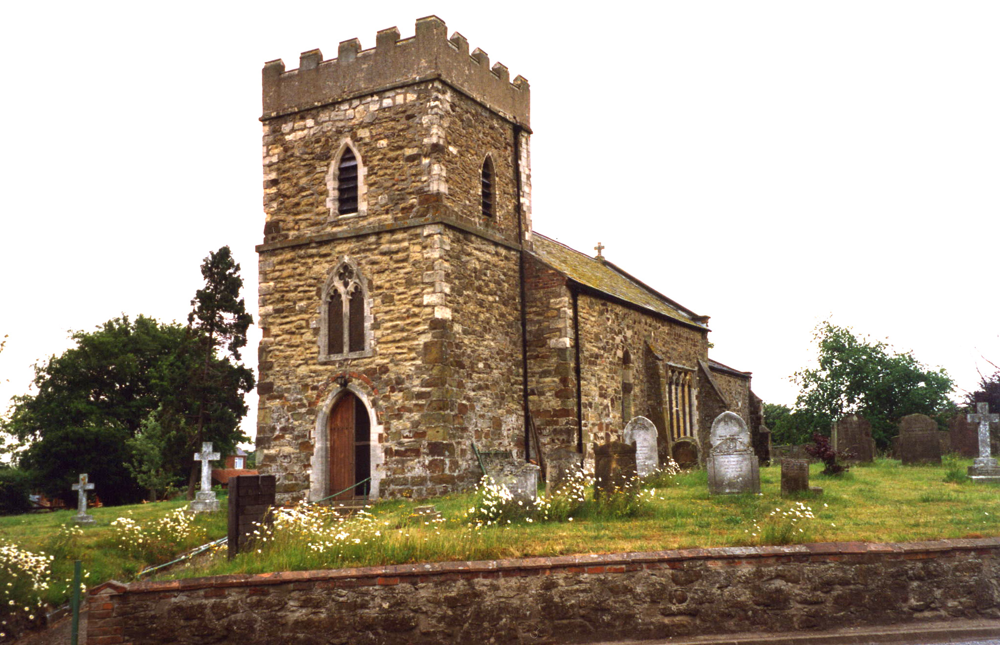
- The Anglican parish church is dedicated to Saint Andrew.
- The font in the church is believed to be from Saxon times, but is probably of Norman origin.
- The church was originally built in the 12th century in the Early English style.
- The church chancel was rebuilt in 1855.
- The church seats about 104.
- The church is a Grade II listed building with British Heritage.
- David HITCHBORNE has a photograph of St Andrew's on Geo-graph, taken in July, 2004.
- Here is a photo of St. Andrew's Church, taken by Ron COLE (who retains the copyright):
- The Anglican parish register dates from 1655, but the early portions are in a "dilapidated condition".
- The LFHS has published several marriage and burial indexes for the Horncastle Deanery to make your search easier.
- The Baptists, the Wesleyan Methodists and the Primitive Methodists each built a chapel here.
- For information and assistance in researching these chapels, see our non-conformist religions page.
- Check our Church Records page for county-wide resources.
- The parish was in the Binbrook sub-district of the Louth Registration District.
- Check our Civil Registration page for sources and background on Civil Registration which began in July, 1837.
Donington on Bain is a parish about 6 miles south-west of Louth and about 9 miles due north of Horncastle. The parish is in the heart of the Wolds and covers about 1,800 acres. Welsdale Bottom (or "Welldale Bottom") is a hamlet about a mile north-east of the village.
The village sits on the east bank of the River Bain. There is a River Bain Restoration Project intended to improve the water flow for fish and eels. If you are planning a visit:
- By car, take the A157 north-east out of Wragby toward Louth. Take the B1225 south and follow the signs for Donington on Bain, which will be on the left (east).
- Passenger railway service existed here from 1875 to 1951.
- See our touring page for visitor services.
- Ask for a calculation of the distance from Donington on Bain to another place.
- A Bronze Age barrow has been found in the parish, but it is hard to see. It is a long, low raised area of soil. Originally, it was 1.5 meters tall, but it has been reduced by ploughing. It is just west of Bluestone Heath Road. A Bronze Age bowl was recovered here.
- The name implies that this was an Anglo-Saxon settlement of circa 800 to 450 BC.
- In 1877, the Louth branch of the Ancient Order of Foresters authorized the building of a Village Hall here. It was completed in 1879.
- J. HANNAN-BRIGGS has a photograph of the Village Hall on Geo-graph, taken in July, 2011. Stop in when they are open and ask for a copy of the schedule of forth-coming events.
- Dennis WETHERLEY has a photograph of the Old Mill at Donington on Bain on Geo-graph, taken in November, 2002.
- Oliver DIXON has a photograph of the Black Horse Inn on Geo-graph, taken in October, 2012. The Pub dates back to the 18th century.
- Here is a list of the Black Horse Inn proprietors:
| Year | Proprietor |
|---|---|
| 1885 | Mathias WHARRAM |
| 1909 | John PARISH, junr. |
| 2015 | Adam and Victoria GARNADE |
- The national grid reference is TF 2382.
- You'll want an Ordnance Survey Explorer #282 map, which has a scale of 2.5 inches to the mile.
- See our Maps page for additional resources.
You can see maps centred on OS grid reference TF235829 (Lat/Lon: 53.328614, -0.147062), Donington on Bain which are provided by:
- OpenStreetMap
- Google Maps
- StreetMap (Current Ordnance Survey maps)
- Bing (was Multimap)
- Old Maps Online
- National Library of Scotland (Old Ordnance Survey maps)
- Vision of Britain (Click "Historical units & statistics" for administrative areas.)
- English Jurisdictions in 1851 (Unfortunately the LDS have removed the facility to enable us to specify a starting location, you will need to search yourself on their map.)
- Magic (Geographic information) (Click + on map if it doesn't show)
- GeoHack (Links to on-line maps and location specific services.)
- All places within the same township/parish shown on an Openstreetmap map.
- Nearby townships/parishes shown on an Openstreetmap map.
- Nearby places shown on an Openstreetmap map.
There is a Roll of Honour inside St. Andrew's church on the west wall. It lists 51 names, of whom 37 returned and 14 died. It appears to be on paper in a wood-framed, glass covered mounting.
There is a list of the names from the Roll of Honour at the Roll of Honour site.
- The name is often found in a variety of spellings. "Donnington" (two Ns) or "Donington" (one N) are two common versions, and the "On Bain" appendage often is found as "Upon" or "Over".
- This place was an ancient parish in Lincoln county and became a modern Civil Parish when those were established.
- The parish was in the North division of the ancient Gartree Wapentake in the East Lindsey district in the parts of Lindsey.
- David HILLAS has a photograph of the Village Hall on Geo-graph, taken in July, 2019. This appears as the "Foresters' Hall" in records prior to 1905.
- You may contact the local Donington on Bain Parish Council regarding civic or political issues, but they are NOT staffed to answer family history questions.
- For today's district governance, see the East Lindsey District Council.
- Bastardy cases would be heard in the Louth petty session hearings.
- In 1669 Elizabeth LOMEN left £44 to benefit the poor. That money was used to purchase 34 acres of land from which the rental income went to the poor each year.
- The Common Lands were enclosed here in 1798.
- As a result of the 1834 Poor Law Amendment Act, the parish became part of the Louth Poor Law Union.
- A National School (Public Elementary School) was built here in 1840.
- For more on researching school records, see our Schools Research page.