
Hide
Kendal
hide
Hide
hide
Hide

Hide
Hide
"KENDAL, a parish, in the county of WESTMORLAND, comprising the incorporated market town of Kirkby-Kendal, the chapelries of Crook, Grayrigg, Helsington, Hugil, Kentmere, Long Sleddale, Natland, New Hutton, Over-Staveley, Old Hutton with Holmescales, which last is a township of the parish of Burton in Kendal, Selside with Whitwell, Underbarrow with Bradley-field, and Winster, and the townships of Docker, Kirkland, Lambrigg, Nether Graveship, Nether Staveley, Patton, Scathwaiterigg-Hay with Hutton in the Hay, Skelsmergh, Kettle-Strickland, Strickland-Roger, Whinfell, and a portion of Fawcet- Forest, in KENDAL ward, and the township of Dilliker in LONSDALE ward, county of WESTMORLAND, and containing, exclusively of the chapelry of Winster, which is returned with Undermilbeck, 17,417 inhabitants, of which number, 8984 are in the town of Kendal, 23 miles (S. W. by S.) from Appleby, and 262 (N. W. by N.) from London, on the great north road. . . . The living is a vicarage, in the archdeaconry of Richmond, and diocese of Chester, rated in the king's books at £92. 5., and in the patronage of the Master and Fellows of Trinity College, Cambridge. The church, dedicated to the Holy Trinity, stands in Kirkland, a hamlet without the liberties."
[From Samuel Lewis A Topographical Dictionary of England (1831) - copyright Mel Lockie 2016]
Hide
There were 15 townships that later became separate parishes:
Kendal, Helsington, Natland, New Hutton, Old Hutton, Grayrigg, Selside, Burneshead, Long Sleddale, Kentmere, Crook, Winster, Staveley, Ings [Hugill], and Underbarrow.
It formerly even included Windermere and Grasmere.
Hide
M.I.s for Kendal were transcribed in Monumental Inscriptions of Westmorland by E. Bellasis 1888-89 and are available on Westmorland Papers.
Transcriptions of memorials inside and outside the church are available on the parish website
| Holy Trinity, Kendal, Church of England |
| St John the Baptist, Skelsmergh, Church of England |
| St Thomas, Kendal, Church of England |
| Friend's Burial Ground, Kendal, Religous Society of Friends |
| Scotch Burial Ground, Kendal, Independant |
| Sepulchre (Friend's Burial Ground), Kendal, Religous Society of Friends |
| Stricklandgate, Kendal, Methodist |
| Blackhall Road, Kendal, Religous Society of Friends |
Returns survive for the 'census' of 1787 for Stricklandgate only and are held at the Kendal Record Office of Cumbria Archives Service. The Record Office reference is WQ/SP/C. They are transcribed in Vital Statistics published by Curwen Archives Trust.
Census returns are available from the usual sources for 1841-1911.
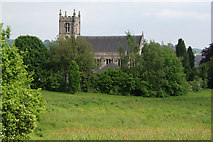
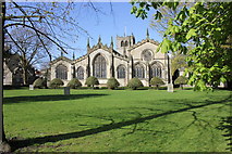 | Holy Trinity Impressive 5-aisled church possibly widest in country. Includes C13th arcade. This and other photographs on Geograph site History and description on Wikipedia. Photograph(s) and description on VisitCumbria. Access and contact details on Church of England site Holy Trinity has its own website |
 | St George 1839-41 by Webster. Chancel of 1910-11 by Austin & Paley. The towers were shortened in 1927 and 1978 Church plans from ICBS archive on Church Plans Online (Lambeth Palace Library).. This and other photographs on Geograph site Photograph(s) and description on VisitCumbria. Access and contact details on Church of England site |
 | St Thomas 1837 also by Webster. Historical and architectural notes on National Heritage List (English Heritage site). This and other photographs on Geograph site Photograph(s) and description on VisitCumbria. Access and contact details on Church of England site |
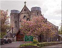
| St John Baptist Skelsmergh 1871 by Joseph Birtley Church plans (1869-71) from ICBS archive on Church Plans Online (Lambeth Palace Library). This and other photographs on Geograph site Photograph(s) and description on VisitCumbriaSt John. Access and contact details on Church of EnglandSt John the Baptist site More details and maps in Genuki Westmorland Church Database |
Parish Registers and Bishop's Transcripts are held by Cumbria Archives :
originals at Kendal RO and microfilm copies at Carlisle RO.
The CASCAT information on these and other parish records.is available by clicking on the WPR refeerence
| All Hallows | Holy Trinity | St George | St Thomas | Skelsmergh | |
| WPR38 | WPR38 | WPR31 | WPR94 | WPR87 | |
| Baptism registers | 1883-1940 | 1558-1940 | 1841-1914 | 1837-1966 | 1871-1936 |
| Marriage registers | - | 1558-1919 | 1849-1922 | 1853-1980 | 1872-1969 |
| Banns registers | - | 1754-1904 | 1892-1957 | - | 1872-1917 |
| Burial registers | - | 1558-1855 | 1842-1855 | 1838-1960 | |
| Bishops transcripts | - | 1673-1845 | 1856-1873 | 1838-1875 | 1871-1884 |
For searching on LDS familysearch.org see IGIbatch numbers (compiled by Jake Prescott)
or use the batch number search site (by Hugh Wallis).
The following registers have been transcribed by Roland Grigg (available through Wayback Machine Internet Archive) :
Baptisms for 1558-1587
(A to D) : (E to M) : (N to Y)
Baptisms 1596 - 99, Marriages and Burials 1591 - 99 and Baptisms 1607 - 31
( A ) : (Ba-Bi) : (Bl-By) : ( C ) : (DE) : (FG) : ( H ) : (IJ) : (K-M) : (N-Q) : ( R ) : ( S ) : (T-V) : (Wa-Wh) : (Wi-Z)
and these registers are included in a combined Cumbrian parish register index (available through Wayback Machine Internet Archive): .
Non-conformist records:
| Roman Catholic | ||
| Kendal | 1762-1941 bap 1856-1900 marr 1856-1966 bur | Kendal RO London PRO (1762-1840) |
| Dodding Green, Skelsmergh | 1864-1889 bur | Kendal RO |
| Methodist | ||
| Wesleyan Circuit Register | 1848-1953 bap | Kendal RO |
| Lowther Street Primitive | 1929-37 bap | Kendal RO |
| Stricklandgate Wesleyan | 1802-1837 bap 1900-1976 mar 1808-1852 bur | Kendal RO & London PRO Kendal RO Kendal RO & London PRO |
| Presbyterian | ||
| Kendal | 1687-1834 bb | London PRO |
| Kendal | 1823-1853 bap 1845-1859 mar 1773-1855 bur | Kendal RO |
| Baptist | ||
| Kendal Unitarian Baptist | 1801-1839 bap | Kendal RO |
| Unitarian | ||
| Kendal | 1687-1843 bap 1725-1855 | Kendal RO |
| Inghamites | ||
| Kendal Pear Tree Chapel | 1757-1782 bap 1779-1801 bur | London PRO |
| Quakers | ||
| Kendal | 1764-1889 births 1765-1927 mar 1764-1893 | Kendal RO |
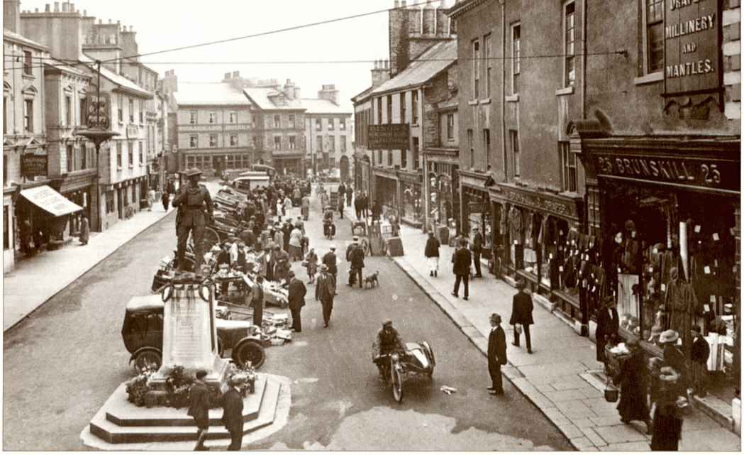
There is a picture of Kendal Market in 1924.
Nicolson and Burn: The history and antiquities of the counties of Westmorland and Cumberland. 1777. Transcribed by Anne Nichols.
"The parish of Kirkby in Kendale is very extensive, comprehanding 24 townships or constablewicks, viz. Kendal, Helsington,, Natland , Scalthwaite Rigg (including Hay and Hutton in the Hay), New Hutton , Old Hutton and Holme Scales, Docker, Lambrigg, Grayrigg , Whinfell, Fawcet Forest, Whitwell and Selside , Slelsmergh and Patton, Burmeshead , Strickland Roger, Strickland Ketel, Long Sleddale , Kentmere , Crook , Winster, Over Staveley, Nether Staveley, Hugill, Underbarrow and Bradley Field; and some of these, for convenience, have been subdivided:- And 15 chapelries, viz. Kendal, Helsington, Natland, New Hutton, Old Hutton, Grayrigg, Selside, Burneshead, Long Sleddale, Kentmere, Crook, Winster, Staveley, Ings [Hugill], and Underbarrow.
This parish was anciently larger; for Windermere and Gresmere were parts thereof, though now they have obtained by reputation the name of distinct parishes, and are the only rectories within the barony of Kendale.
It is bounded on the East by the parishes of Shap, Orton, Sedberg, and Kirkby Lonsdale; on the South, by the parishes of Kirkby Lonsdale, Burton, and Heversham; on the West, by the parishes of Heversham and Windermere; and on the North, by the parishes of Windermere, Gresmere, and Orton.
The church of Kendal stands in Kirkland, from whence the place hath received its name. It is a very large, neat, and handsome building, and contains every Sunday as large a congregation, as almost any parish church in the kingdom. It is 180 feet long, and 99 feet in breadth; with five alleys, each of them being parted by a row of 8 fair pillars; and with a strong square steeple, wherein there are 6 large and very tunable bells.
It is a vicarage, in the patronage of Trinity college in Cambridge
Helsington [is] below Kendal, on the West side of the river Kent. Advancing Eastward from Helsington, we come to Natland, which is a small manor or lordship, containing only about 30 families [in 1777]. It seems to have had its name from the Nativi or bondmen probably placed there, as attendent upon the capital lord at Kendal castle to do servile offices, like as the inhabitants of Bongate nigh Appleby, or the Drengage tenants nigh Brougham castle. The chapelry also of Natland is commensurate to the manor.
Old Hutton, New Hutton, and Holme Scales... At first there was only one general name of Hutton. The distinction between Old and New Hutton seems to have come in about the beginning of the reign of king Edward the first [c.1272]. Holme Scales is in the parish of Burton; being, as the name imports, scales or huts belonging to Holme in that parish. But for the sake of vicinity and convenience, Holme Scales hath for a long time been annexed to Old Hutton, and is now deemed part of that township or constablewick. Docker.. this place claims, and in some respects exerciseth, a privilege of exemption from ecclesiastical jursidiction; but by whom, or in what instances, the same hath been granted, we have not found. Lambrigg... This perhaps might be the place to which they carried their lambs at certain seasons. For many places received their name of distinction from such like circumstances; as Sheepshead, Ramsbottom, Ewbank, Stirkland, Cowbrow, Oxenholme, and the like.Dillaker... Adjoining to lambrigg on the East, is the hamlet of Dillaker; of which we have met with no particular account. Grayrigg... Having now advanced to the Eastern extremity of the parish of Kendal, we incline Northwards to the manor of Grayrigg; so called probably from being frequented by badgers, brocks, or grays; as on the east side of the river Lune, opposite thereto, is a place which yet bears the name of Brockholes. The hollow between is called Grayrigg-hause, from haustus perhaps, which signifies a draught; even as yet a throat or gulley is by the common people called a hause. There is a meeting-house in Grayrigg belonging to the Quakers. Whinfell... From Grayrigg, travelling northwards, along the eastern extremity of the parish, we come to Whinfell; which carries its own derivation along with it.
Fawcet Forest...Pursuing our course northwards, we come to Fawcet Forest, at the utmost extremity of the parish towards the east and north. It was anciently called Fauside. It is within the chapelry of Selside.Whitwell and Selside... Inclining westward, we come to Whitwell and Selside, which though separate divisions, yet make but one constablewick, and seem to have been originally but one manor. When they were first separated doth not appear.
Skelsmergh and Patton... Skelsmergh and Patton are one constablewick, but they have been separate divisions for a long time. There was heretofore a chapel in Skelsmergh, dedicated to St. John Baptist; with the stream of a well, called St. John's well, running through it from East to West.
Burneshead... This name is variously written in ancient time, but most commonly Burneshead, and seems intended to signify the head of the burn or river which springs a little above in Kentmere. The chapel of Burneshead is common to Burneshead, Strickland Roger, and Strickland Ketel. To what saint it was dedicated, we have not certainly found. There is a well called the Miller's, formerly St. Oswald's well, about 30 yards north-east from the chapel, which probably leads to the name of the tutelar saint
Strickland Roger and Strickland Ketel... Strickland anciently was always written Stirkland, being no other than the pasture ground of the stirks or steers and other young cattle.
Long Sleddale... The chapel stands about the middle of the dale, and was made parochial... in 1712. Sleddale Beck, commonly called Spret, springs up in Wrangdale- head in this dale (a place famous for fine blue slate got there), runs southward all along the dale on the west side of the chapel and Ubarrow Hall, from thence on the east side of Burneshead Hall, and about half a mile below falls into the river Kent.Kentmere... This place hath its name from the river Kent, which springs there, and from a mere or lake therein called Kentmere; which river gives name not only to this particular district, but to all the south-west part of this county, called Kendale. It springs about 3 miles north from the chapel, and from thence runs southward through Kentmere, Staveley, Strickland, the township of Kendal, by Natland, Helsington, Levins, and from thence into the sea. It receives in its course two small rivers, Sprit and Mint. The former springs in Long Sleddale , and runs in at Burneshead. The other springs in Fawcet Forest, and its course meets with Grayrigg water which springs above the hall, and falls into Kent about a mile above Kendal. Kentmere is bounded on the East by the chapelry of Long Sleddale, on the South by the chapelries of Staveley and Ings, on the West by the top of Garburne Fell, and on the North by Patterdale in the parish of Barton and Mardale in the parish of Shap.
Staveley and Hugill... Having now advanced to the furthest extremity of the parish towards the north-west, we turn southwards to Staveley and Hugill. Staveley and Hugill are bounded on the east by Long Sleddale, being divided therefrom by the ridge of Potter Fell; on the south by Underbarrow, being divided by the top of Ratherhead; on the west by Crook, being divided by the ridge of Brackenthwait Fell; and on the north by Kentmere, being divided by Blackbeck which runs by Milrigg. The chapel of Staveley is a fair building, with a handsome steeple and three good bells. To what saint it was dedicated is not certain: From the inscription on one of the bells, it seems to have been St. Margaret. Staveley and Hugill were originally one chapelry. But afterwards a separate chapel was erected at Ings in Hugill, so called from a long Ing or watery meadow, at the head of which it stands. As Grasgarth there was anciently a chapel called St. Anne's, about a quarter of a mile north-west from the present chapel of Ings.
Crook and Winster... These two, in like manner as Staveley and Ings, were originally one chapelry; but now they are two distinct chapelries. The chapel of Crook is a fair building, with a tower steeple, and one bell. Winster, though it is in the parish of Kendal, yet is said to be in the constablewick of Undermilbeck in the parish of Windermere. The chapelry of Winster was anciently a part of the chapelry of Crook. This place gives name to the rivulet called Winster Beck; which almost from head to foot divides Westmorland from Lancashire.
Underbarrow and Bradley Field... This is the last division that remains to be spoken of in the parish of Kendal. Underbarrow hath its name from its situation under the barrow, hill, or scar, which extends from north to south all along in this division. That part which is called Bradley Field received its denomination from a family of the name of Bradley, which came from Bradley in Lancashire. There was an ancient chapel at this place [Underbarrow]. In the year 1708, this chapel was rebuilt at the expence of the inhabitants of Underbarrow only (for Bradley Field is not in the chapelry). "
The details for the parish from the Parson & White's Directory for 1829 are transcribed on Edenlinks site.
- Ask for a calculation of the distance from Kendal to another place.
Described in 1199 as Kirkeby in Kendal - i.e. the valley of the River Kent.
Records relating to the Barony of Kendale, CWAAS, William Farrer & John F. Curwen (editors) are available on British History Online for
- Kirkby in Kendale - c.1100-1350
- Kirkby in Kendale - 1352-1450
- Kirkby in Kendale - 1453-1530
- Kirkby in Kendale - 1532-60
- Kirkby in Kendale - 1572-1650
- Kirkby in Kendale - 1663-1739 and addenda
- Supplementary Records - Kirkby in Kendale
- Dillicar & Supplementary Records - Dillicar
- Skelsmergh and Paton & Supplementary Records - Skelsmergh and Paton
- Strickland Roger & Supplementary Records - Strickland Roger and Strickland Ketel
- Strickland Ketel
Records relating to The Barony of Kendale by William Farrer have also been transcribed on EdenLinks
Cumbria County History Trust has published a "Jubilee Digest" for the township of Kendal , Dillicar , Skelsmergh and Patton
and a completed VCH draft township history for Skelsmergh
Kendal from Magna Britannica et Hibernia.Volume 6: Westmorland by Thomas Cox 1731.
Much historical material is available for Dodding Green on the Edenlinks site.
Some museums have websites:
- Abbot Hall Art Gallery. Georgian villa, with important collections 18th, 19th and 20th century art.
- Blackwell. Arts and Crafts house
- Kendal Museum. Founded 1796 - one of the country's oldest museums. Local archaeology, history, geology, and natural science from around the world.
- Museum of Lakeland Life . Collections on: the Arts and Crafts movement; Arthur Ransome; and Victorian social history of Lakeland Victorians.
There is a C17th map of Kendale by John Speed on Univ. of Portsmouth, Geography Dept. site.
You can see maps centred on OS grid reference SD532946 (Lat/Lon: 54.344825, -2.721235), Kendal which are provided by:
- OpenStreetMap
- Google Maps
- StreetMap (Current Ordnance Survey maps)
- Bing (was Multimap)
- Old Maps Online
- National Library of Scotland (Old Ordnance Survey maps)
- Vision of Britain (Click "Historical units & statistics" for administrative areas.)
- English Jurisdictions in 1851 (Unfortunately the LDS have removed the facility to enable us to specify a starting location, you will need to search yourself on their map.)
- Magic (Geographic information) (Click + on map if it doesn't show)
- GeoHack (Links to on-line maps and location specific services.)
- All places within the same township/parish shown on an Openstreetmap map.
- Nearby townships/parishes shown on an Openstreetmap map.
- Nearby places shown on an Openstreetmap map.
Details of Kendal Union workhouse are given on on the websites of Ross Brett (Internet Archive) and Peter Higginbotham .
Wills for Kendal will be at Carlisle since about 1858 but before that will be at the Preston R.O. as it was in the Diocese of Chester until that time.
Hearth Tax records for 1674 Kendal Parke & Oxenholme transcribed on Edenlinks.
Hearth Tax records for 1674 Dilliker (Kendal) transcribed on Edenlinks
Hearth Tax records for 1674 Patton & Skelsmergh transcribed on Edenlinks
Hearth Tax records for 1674 Strickland Roger (Kendal) transcribed on Edenlinks.