
Hide
Stallingborough
hide
Hide
hide
Hide
hide
Hide
Hide
hide
Hide
Stallingborough, par. and vil. with ry. sta., Lincolnshire - par., 4,302 ac. land and 1,490 water, pop. 483; vil., 5 miles NW. of Grimsby; P.O.
From: John BARTHOLOMEW's "Gazetteer of the British Isles (1887)"
Hide
The Grimsby Library is an excellent resource with both a Local History section and a Family History section.
Alternatively, the Caistor Library also has a Local History section.
Jonothan THACKER has a photograph of the churchyard on Geo-graph, taken in March, 2011.
Stallingborough is reportedly the burial place of the Anglo-Saxon Saint Avbur. A chapel to St. Avbur is mentioned in a will of Ric[hard] Hooton of Stallingborough dated 1530. St. Avbur was an Anglo-Saxon woman who is largely undocumented. Her tomb was here in Stallingborough.
- The parish was in the Grimsby sub-district of the Caistor Registration District.
- In an 1890 re-organisation, the Grimsby sub-district became its own Registration District.
- Check our Census Resource page for county-wide resources.
- The table below gives census piece numbers, where known:
| Census Year | Piece No. |
|---|---|
| 1861 | R.G. 9 / 2391 |
| 1871 | R.G. 10 / 3417 |
| 1891 | R.G. 12 / 2620 |
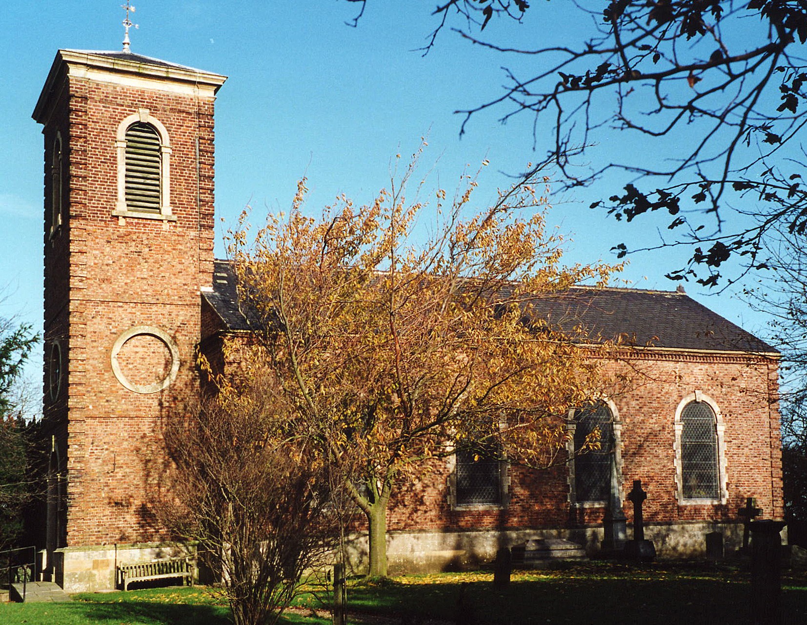
- The medieval church here collapsed in 1746.
- The present Anglican parish church is dedicated to Saint Peter and Saint Paul.
- The church was built in 1780 at the west end of the village. It replaced an earlier structure.
- The church seats 200.
- There is a photograph of Saints Peter and Paul church on the Wendy PARKINSON Church Photos web site.
- Paul GLAZZARD has a photograph of St Peter & St Paul Church on Geo-graph, taken in May, 2008.
- Here is a photo of Saints Peter and Paul Church, taken by Ron COLE (who retains the copyright):
- The Anglican parish registers date from 1588 (another source gives 1562).
- The LFHS has published several indexes for the Haverstoe Deanery to make your search easier.
- Check our Church Records page for county-wide resources.
- The Primitive Methodists built a chapel here in 1871.
- The Wesleyan Methodists built a chapel here in 1864. It has since been converted to a private residence.
- Ian S. has a phtotgraph of the Former Methodist Chapel on Geo-graph, taken in March, 2017.
- For more information on researching these chapels, see our non-conformist religions page.
- The parish was in the Grimsby sub-district of the Caistor Registration District.
- In an 1890 re-organisation, the Grimsby sub-district became its own Registration District.
- Check our Civil Registration page for sources and background on Civil Registration which began in July, 1837.
Stallingborough is a village and a parish on the south bank of the Humber River just above Grimsby and 159 miles north of London. Immingham parish lies to the north and Healing parish to the south. The parish covers just over 4,500 acres and includes the hamlet of Little London.
If you are planning a visit:
- Tour the Stallingborough.com website first.
- David WRIGHT has a photograph of Stallingborough Station on Geo-graph, taken in October, 2005.
- Nigel THOMPSON also has a photograph of the Stallingborough railway station on geo-graph, taken in July, 2011.
- Stallingborough railway station was built by the Great Grimsby and Sheffield Junction Railway in 1848. The station building is a private house now, but there are shelters on both platforms.
- See our touring page for visitor services.
- Ask for a calculation of the distance from Stallingborough to another place.
Sir William AYSCOUGH (Askew), Sheriff of Lincolnshire, MP, was born in the year 1486 in Stallingborough.
- South-east of the village there is evidence of an Iron Age complex of enclosures.
- There are traces of an abandoned medieval Stallingborough. Richard CROFT has a photograph of a footpath intersection on Geo-graph, taken in March, 2009. The abandoned village is on the western end of the existing village.
- The parish was prime grazing land for many centuries.
- A lighthouse (Stallingborough Light) was built in 1849, located in the Ferry House on the east bank of the outlet onto the Humber of the North Beck Drain.
- In 1900, Stallingborough had a Coast Guard station on the shore.
- J. THOMAS has a photograph of the Green Man Pub. on Geo-graph, taken in March, 2013.
- The AYSCOUGH family were long seated here, but by 1840 only the ruin of the west wing of their mansion still remained. The name is also spelled as AYSCUGH, AYSCOUGE and ASKEW.
- See our Maps page for additional resources.
You can see maps centred on OS grid reference TA202116 (Lat/Lon: 53.587003, -0.185308), Stallingborough which are provided by:
- OpenStreetMap
- Google Maps
- StreetMap (Current Ordnance Survey maps)
- Bing (was Multimap)
- Old Maps Online
- National Library of Scotland (Old Ordnance Survey maps)
- Vision of Britain (Click "Historical units & statistics" for administrative areas.)
- English Jurisdictions in 1851 (Unfortunately the LDS have removed the facility to enable us to specify a starting location, you will need to search yourself on their map.)
- Magic (Geographic information) (Click + on map if it doesn't show)
- GeoHack (Links to on-line maps and location specific services.)
- All places within the same township/parish shown on an Openstreetmap map.
- Nearby townships/parishes shown on an Openstreetmap map.
- Nearby places shown on an Openstreetmap map.
- David WRIGHT has a photograph of a Commonwealth War Grave from World War I on Geo-graph, taken in October, 2005.
- This place was an ancient parish in Lincoln county and became a modern Civil Parish when those were established.
- The parish was in the east division of the ancient Yarborough Wapentake in the Central Lindsey district in the parts of Lindsey.
- Kelly's 1900 Directory of Lincolnshire places the parish, perhaps erroneously, in the North Lindsey district.
- You can contact the Stallingborough Parish Council regarding civic or political issues, but they are NOT funded to assist you with family history searches.
- For today's district governance, visit the North East Lincolnshire District Council site.
- J. THOMAS has a photograph of the Village Hall on Geo-graph, taken in March, 2013. Stop in and ask to see the Schedule of Forth Coming Events. Family and local history are often topics presented at the hall.
- Bastardy cases would be heard in the Grimsby petty session hearings.
- After the 1834 Poor Law Amendment Act reforms, the parish became part of the Caistor Poor Law Union.
- In 1890, the parish was transfered to the newly established Grimsby Poor Law Union, which built a new Workhouse on 9th October 1894.
- A Church of England School was built here in 1847 and enlarged in 1887.
- See our Schools page for more information on researching school records.