
Hide
Loughor
hide
Hide
hide
Hide
hide
Hide
Hide
"A decayed town at the mouth of the Loughor river eight miles north-west of Swansea, generally identified with the Roman Leucarum . At the vicarage is an Ogam stone made out of a Roman altar, and by the side of the river are the ruins of a medieval castle." [Glamorganshire, 1911]
"Lochor, or Llwchwr, was the Leucarum mentioned in the Itineraries, and the fifth Roman station on the Via Julia. This small village is situated on a tide-river bearing the same name, which divides the counties of Glamorgan and Carmarthen, and over which there is a ferry. ' Lochor river partith Kidwelli from West Gowerlande'(Leland). (The ferry is no more. The river is crossed by a fine railway bridge).
The Itinerary Through Wales and The Description of Wales by Giraldus Cambrensis (1188).The text is that of Sir Richard Colt Hoare who published an English translation in 1806, chiefly from the texts of Camden and Wharton . This extract is from the foot-notes in the Everyman's Library edition, (ed. Ernest Rhys) 1908.
Hide
Here is a substantial reading list of books which relate to Glamorgan, either county or parish.
Various iems - on the People's Collection Wales site
- RCAHMW drawing showing plan of Loughor Zinc Works.
- LOUGHOR, GLASSWORKS (SITE OF)
Chapels Database - a list of all known non-conformist chapels or other non-Anglican religions in the parish
See Welsh Chapels and Churches for a photograph
Various items - on the People's Collection Wales site.
- MORIAH CHAPEL AND SCHOOLROOM, LOUGHOR
- Moriah Methodist Chapel was built in 1828, modified in 1836, 1842 and again in 1849 with the addition of a gallery. The chapel was then rebuilt in 1898, by architect W. Jones of Rhondda, in the Romanesque style with an entrance in the gable end and a large arch in the facade. The schoolroom is probably converted from the original chapel.
- PISGAH, PISGAH BWLCHNEWYDD, LOUGHOR,
- Sunday School at Moriah Calvinistic Methodist chapel, Loughor
For full and up-to-date details of their holdings see the sites of Glamorgan Record Office and/or West Glamorgan Archives
See Bap/Mar/Bur data on FreeReg
The church is dedicated to St. Michael, is in the Benefice of Lougher, and the diocese of Swansea and Brecon. Details of the present incumbent of this benefice can be found at the Church in Wales website. The church can be located at grid reference SS563980.
| Anglican Parish Registers Held at the Glamorgan Record Office, Cardiff | ||||
| Baptisms | Marriages | Burials | Banns | Bishops Transcripts |
| 1717-1921 | 1717-1752, 1754-1924 | 1717-1912 | 1792-1832 | 1678-1679, 1681-1682, 1684, 1686-1687, 1694-1696, 1700-1702, 1704, 1707-1708, 1713, 1718, 1725-1727, 1730-1734, 1736-1737, 1740-1742, 1745-1747, 1750-1751, 1753-1757, 1759-1796, 1798-1800, 1802-1803, 1805-1883, 1885, 1887-1892 (At the National Library of Wales, Aberystwyth) |
Details of extant records on Archives Network Wales for the following;
- Loughor Ecclesiastical Parish Records " Registers (including service and banns registers) 1717-1994; papers relating to tithes and church property 1841-1924; papers relating to church building and restoration 1884-1946; Vestry minutes and Churchwardens accounts 1865-1906; papers relating to church school 1835-1918"
Modern Parishes & Chapels of Ease :-
- St. David, Lougher
- St. John the Evangelist, Gowerton - Chapel of Ease to Loughor, formed into a parish circa 1920.
The following Religious Institutions are covered in the Mormon International Genealogical Index (IGI) :-
- Loughor, St. Michael - Christenings (BT's), 1813-1875
| Non Conformist Registers Deposited | |||||
| Chapel | Baptisms | Marriages | Burials | OS Map Ref | Deposited/ Copies |
| Moriah Calvinistic Methodist | 1832-1841 | - | - | SS 57709811 | NLW |
| Horeb, Congregational* (*not on WGAS online list) | *1918-1980 | - | - | SS 56399803 | WGAS |
| Horeb, Congregational | 1942-1980 | WGAS | |||
NLW - National Library of Wales, Aberystwyth
WGAS - West Glamorgan Archive Service
Transcript of name listing for Loughor from Commercial and Trade Directories, for the years:-
| 1871 | (Post Office Directory) |
The transcription of the section for Loughor from The National Gazetteer (1868) provided by Colin Hinson.
Descriptions of the parish from
A Topographical Dictionary of Wales (1833) by Samuel Lewis.
A Topographical Dictionary of The Dominion of Wales by Nicholas Carlisle, London, 1811
- Ask for a calculation of the distance from Loughor to another place.
Some of the hamlets, towns and villages within this parish
Description and images of Loughor Castle, Loughor at www.castlewales.com by Lise Hull
Aerial photograph of Loughor Castle 1997 - on the People's Collection Wales site (use search box)
I remember Loughor by Sheila Francis
Loughor, Castle & Town, by William Butler - on Swansea Heritage net
Loughor, with Glass Kiln, by William Butler - on Swansea Heritage net
Loughor Train Crash - on the People's Collection Wales site
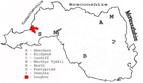
This diagram shows the position of this parish within the county of Glamorgan - click on this to see a full size diagram of the county
|
The borough and parish of Loughor in the County of Glamorgan - on the People's Collection Wales site
Parish map (Kain/Oliver)
You can see maps centred on OS grid reference SS586965 (Lat/Lon: 51.649868, -4.044728), Loughor which are provided by:
- OpenStreetMap
- Google Maps
- StreetMap (Current Ordnance Survey maps)
- OpenStreetMap Cymru (Welsh counties only)
- Bing (was Multimap)
- Old Maps Online
- National Library of Scotland (Old Ordnance Survey maps)
- Vision of Britain (Click "Historical units & statistics" for administrative areas.)
- Magic (Geographic information) (Click + on map if it doesn't show)
- GeoHack (Links to on-line maps and location specific services.)
- All places within the same township/parish shown on an Openstreetmap map.
- Nearby townships/parishes shown on an Openstreetmap map.
- Nearby places shown on an Openstreetmap map.
Places, villages, farms etc within Loughor parish as shown on the online parish map from the CD of Historic Parishes of England and Wales: an Electronic Map of Boundaries before 1850 with a Gazetteer and Metadata [computer file]. (Kain, R.J.P., Oliver, R.R.). (Extracted by Mary Greatorex)
- Loughor (1): Bwlch-y-mynydd, Fernel, Kings Bridge, Leucarum (site of), Loughor, Loughor Castle, Upper Loughor
- Detached (1); Alltwen, Bank-y-Cwm, Berthlwyd, Bevexe fach, Cae Mansel, Cefn-golau, Cefn-golau farm, Cefn-gorwydd, Cwm Mansel, Felin fach, Gelli-eithrym, Gowerton, Island House, LM&SR railway line, Steel works.
- Gowerton (2); Afon Llan, Colliery, Garden Village, Hospital, Hospital, Pen-y-fodau fach, Pen-y-fodau fawr, Stafford Common, Trafle, Tumulus. (Places, villages, farms etc lying outside the borough of Loughor in the division of Gowerton as shown in the parish map of Loughor)
- Broad Oak Colliery, Loughor on the Welsh Coal Mines site
- Cae Duke Colliery, Upper Loughor on the Welsh Coal Mines site
Details of extant records on Archives Network Wales for the following;
- J M Davies (Treboeth) "Paysheets, Broad Oak Colliery, Loughor, 1929."
Details of extant records on Archives Network Wales for the following;
- Borough of Loughor records "Borough of Loughor and Town Trust records, West Glamorgan, 1833-2003, including minute books, 1833-1873; Loughor Town Trust records, 1890-1928; and Loughor Borough Council Records, 1876-1881."
- Llwchwr Urban District Council, records 1853-1983
Mr Evan Roberts and the Revivalists from Loughor, 1905 - on the People's Collection Wales site (use search box)
Details of extant records on Archives Network Wales for the following;
- Loughor Lower School "Log books of Loughor Lower School, 1882-1967"
- Loughor Upper School "Logbooks of Loughor Upper School, 1863-1952 "