
Hide
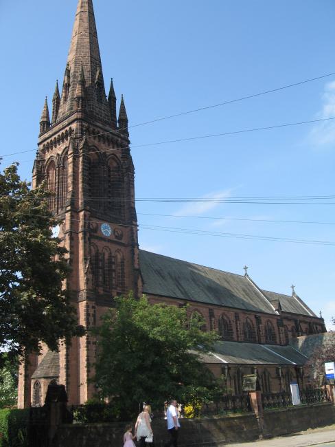
St Mary without the Wall, Chester, Church of England
hide
Hide
Hide
St Mary without the Wall,
Overleigh Road, Handbridge,
Chester
Hide
It was founded in 1887.
Overleigh Road, Handbridge.
Church History
Built in 1887 as a replacement church for Chester: St. Mary on the Hill, serving part of the city of Chester and part of the township of Marlston cum Lache.
The district was affected by the following boundary changes:
- 1887 September 27 — reduced when the following area was transferred to Chester: St. Olave: "That portion of the parish of Saint Mary-on-the-Hill which is situate on the north side of the River Dee and on the east side of Bridge-street aforesaid".
- 1887 September 27 — reduced when the following area was transferred to Chester: St. Bridget: "All that portion of the said parish of Saint Mary-on-the-Hill which is bounded on the south by the River Dee on the east by the centre of Lower Bridge-street in the city of Chester from the south boundary of the said parish to a point where Duke-street in the same city debouches into Lower Bridge-street aforesaid, and thence partly by the said parish of Saint Olave partly by the said parish of Saint Michael and partly by a detached portion of the parish of Saint Bridget on the north partly by the said parish of Saint Michael partly by the said parish of Saint Bridget and partly by the said parish of Saint Martin and on the east by the said parish of Holy Trinity. And also all that detached portion of the said parish of Saint Mary-on-the-Hill abutting upon Lower Bridge-street aforesaid at the northerly end thereof bounded on the south- east and north sides thereof by the said parish of Saint Michael and on the west side by a detached portion of the said parish of Saint Bridget"
- 1887 September 27 — enlarged when the following area was transferred from Chester: St. Bridget: "Part of the said parish of Saint Bridget situate on the south side of the said river in the city of Chester... bounded on the north and east sides thereof by the parish of Saint John the Baptist in the city of Chester along the course of the said River Dee and on the south and west sides thereof by the said parish of Saint Mary-on-the-Hill."
- 1923 October 12 — reduced when the following area was transferred to Lache cum Saltney: St. Mark: "All that portion of the Parish of Saint Mary on the Hill, Chester, in the said County of Chester and in the said Diocese of Chester, which is bounded upon the west and upon the south west by the said New Parish of Lache cum Saltney, and upon the remaining sides, that is to say, upon the south east, upon the east and upon the north west, by an imaginary line commencing at the point where the boundary which divides the said New Parish of Lache cum Saltney from the said Parish of Saint Mary on the Hill, Chester, crosses the fence which forms the south eastern boundary of the close numbered 80d upon the Ordnance Survey Map of the Civil Parish of Chester published in the year 1911 on the scale of 25 inches to a mile and also upon the map or plan annexed to this Scheme or Representation, and extending thence north eastward along the said fence and along the fence forming the south eastern boundary of the close numbered 80 upon the said maps for a distance in all of 8½ chains or thereabouts to the point where the last mentioned fence meets the fence forming the north eastern boundary of the said close numbered 80, and extending thence north westward along the last mentioned fence and along the fence forming the north eastern boundary of the close numbered 100 upon the said map for a distance in all of 22½ chains or thereabouts to the point where the last mentioned fence meets the fence at the eastern end of the roadway which runs along the backs of the houses and premises situate on the southern side of the road called Hough Green, and extending thence northward along the last mentioned fence and along the fence forming the eastern boundary of the house and premises known as Heath-field, Number 23, Hough Green, for a distance in all of 5¼ chains or thereabouts to the point where the last mentioned fence meets the southern side of Hough Green, and extending thence first northward to and then eastward along the middle of Hough Green for a distance in all of 12 chains or thereabouts to its junction with Selkirk Road, and extending thence northward along the middle of Selkirk Road for a distance of 4 chains or thereabouts to its present northern end, and continuing thence northward in precisely the same direction and in a straight line for a distance of 26 chains or thereabouts to a point in the middle of the Chester and Holyhead Line of the London, Midland and Scottish Railway, and extending thence south westward along the middle of the
said line of railway for a distance of 20½ chains or thereabouts to the boundary which divides the said Parish of Saint Mary on the Hill, Chester, from the said New Parish of Lache cum Saltney."
Church Records
C = Christenings (Baptisms) ; M = Marriages ; B = Burials ; BTs = Bishop's Transcripts
| Original Registers | C 1887-1984 ; M 1887-1987 — Cheshire Archives (P 20) C from 1984 ; M from 1987 ; B from 1963 — Church |
| Microfilm Copies | C 1887-1922 ; M 1887-1953 — Cheshire Archives C 1887-1898 ; M 1887-1910 — Manchester Archives & Local Studies ; Family History Society of Cheshire |
| Bishop's Transcripts | 1888-1894 (microfilmed) — Cheshire Archives, Family History Society of Cheshire |
| Copies and Indexes | M 1887-1958 — Cheshire BMD (CW:CE14) B 1963-2007 (notebook) — Cheshire Archives |
It is located at SJ4069165460 (Lat/Lon 53.182912, -2.888944). You can see this on maps provided by:
- OpenStreetMap
- Google Maps
- StreetMap (Current Ordnance Survey maps)
- Bing (was Multimap)
- Old Maps Online
- National Library of Scotland (Old Ordnance Survey maps)
- Vision of Britain (Click "Historical units & statistics" for administrative areas.)
- English Jurisdictions in 1851 (Unfortunately the LDS have removed the facility to enable us to specify a starting location, you will need to search yourself on their map.)
- Magic (Geographic information) (Click + on map if it doesn't show)
- GeoHack (Links to on-line maps and location specific services.)