
Hide
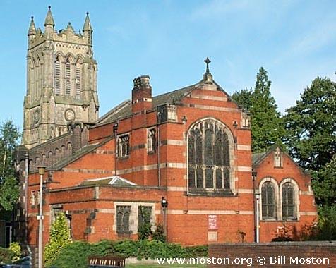
Christ Church, Crewe, Church of England
hide
Hide
Hide
Christ Church,
Prince Albert Street,
Crewe
Hide
It was founded in 1845.
Moss Square.
Church History
Founded in 1846 as a chapel to Coppenhall: St. Michael. In 1855 it became a district church for part of the township of Monks Coppenhall (previously served by Coppenhall: St. Michael). The boundaries of "The District Chapelry of Christ Church, Crewe" were described in the London Gazette on 13 February 1855:
"Commencing at Liverpool Bridge, on the north-east, and proceeding from thence, westerly, along Earle-street to Coppenhall-street; then northerly along the middle of the latter street to Victoria-street, and then proceeding westerly along the middle of that street and the lane to Wistaston, southerly, as far as the north-west angle of the field, No. 231 on the Tithe commutation Map of the said parish of Coppenhall; and then proceeding southerly along the footpath running by the western fences of the fields Nos. 231, 225, 224, 206, 202, and 203 on the said map, and enters the Nantwich-road, and along such road to the western corner of field No. 190, when it meets the boundary line separating the said parish of Coppenhall from the parish of Wybunbury; then proceeding easterly along such boundary line as far as the boundary line separating the said parish of Coppenhall from the parish of Barthomley; and then proceeding northerly along such boundary line as far as the Brook and the Liverpool line of Railway; and then proceeding up the middle of that railway, northerly, as far as Liverpool Bridge, where the boundary line of the said district chapelry commenced"
The district was affected by the following boundary changes:
- 1914 April 7 — reduced when part of the township of Monks Coppenhall was transferred to Crewe: St. John the Baptist.
- 1926 August 13 — reduced when part of the town of Crewe was transfered to Crewe: St. Andrew.
- 1961 November 27 — boundary alteration (details not available)
Church Records
C = Christenings (Baptisms) ; M = Marriages ; B = Burials ; BTs = Bishop's Transcripts
| Original Registers | C 1846-2012 ; M 1855-1966 ; B 1846-1912 — Cheshire Archives (P 136) C from 2012 ; M from 1966 — Church |
| Microfilm Copies | C 1846-1910 ; M 1855-1912 ; B 1846-1912 — Cheshire Archives |
| Copies and Indexes | M 1855-1912 — South Cheshire Family History Society M 1855-1966 — Cheshire BMD (CC:1029) |
| Monumental Inscriptions | South Cheshire Family History Society, 1997 |
- OpenStreetMap
- Google Maps
- StreetMap (Current Ordnance Survey maps)
- Bing (was Multimap)
- Old Maps Online
- National Library of Scotland (Old Ordnance Survey maps)
- Vision of Britain (Click "Historical units & statistics" for administrative areas.)
- English Jurisdictions in 1851 (Unfortunately the LDS have removed the facility to enable us to specify a starting location, you will need to search yourself on their map.)
- Magic (Geographic information) (Click + on map if it doesn't show)
- GeoHack (Links to on-line maps and location specific services.)