
Hide
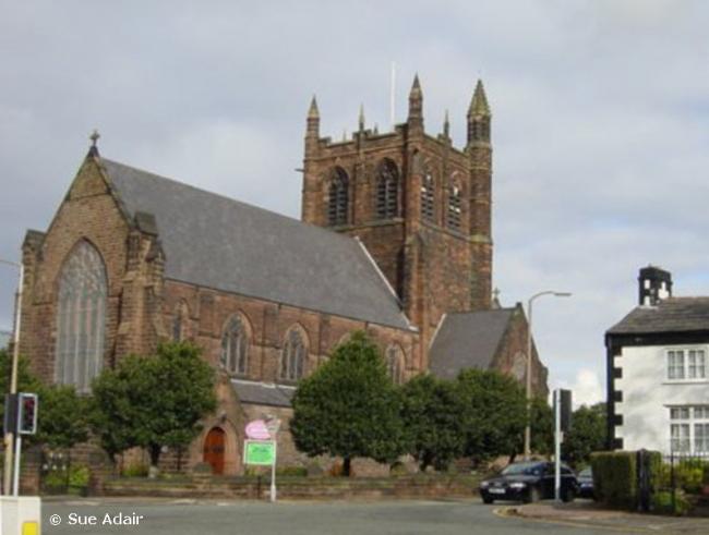
St Saviour, Oxton, Church of England
hide
Hide
Hide
St Saviour,
Bidston Road,
Oxton
Hide
^Click the arrow on the line above to find links to search for web sites of current churches when one is not listed here, or within the address. Some churches keep closing so if it has had to close then please let us know.
It was founded in 1851.
Bidston Road/Gerald Road.
Church History
Founded in 1851 as the district church for the township of Oxton, and part of the township of Claughton with Grange (previously served by Woodchurch: Holy Cross).
The district was affected by the following boundary changes:
- 1876 October 31 — reduced when parts of the townships of Claughton with Grange and Oxton were transferred to Claughton: Christ Church.
- 1902 March 7 — reduced when part of the township of Oxton was transferred to Prenton: St. Stephen.
- 1911 January 24 — reduced when part of the township of Oxton was transferred to Birkenhead: St. Bede.
- 1948 February 27 — reduced when the following area was transferred to Prenton: St. Stephen: "All that portion of the said parish of Saint Saviour, Oxton, bounded upon the south east, the south and the west by the said parish of Saint Stephen, Prenton, and upon the remaining side, that is to say, upon the north west by an imaginary line commencing on the boundary which divides the said parish of Saint Stephen, Prenton, from the said parish of Saint Saviour, Oxton, at a point in the middle of Woodchurch Road where that road is crossed by Storeton Road and extending thence north eastwards along the middle of Woodchurch Road to the boundary which divides the said parish of Saint Saviour, Oxton, from the said parish of Saint Stephen, Prenton."
Church Records
C = Christenings (Baptisms) ; M = Marriages ; B = Burials ; BTs = Bishop's Transcripts
| Original Registers | C from 1844 ; M from 1851 — Church |
| Bishop's Transcripts | 1851-54, 1876-96 (microfilmed) — Cheshire Archives |
| Copies and Indexes | M 1851-1942 — Cheshire BMD (WR:BK14) |
It is located at SJ3013987782 (Lat/Lon 53.382246, -3.051734). You can see this on maps provided by:
- OpenStreetMap
- Google Maps
- StreetMap (Current Ordnance Survey maps)
- Bing (was Multimap)
- Old Maps Online
- National Library of Scotland (Old Ordnance Survey maps)
- Vision of Britain (Click "Historical units & statistics" for administrative areas.)
- English Jurisdictions in 1851 (Unfortunately the LDS have removed the facility to enable us to specify a starting location, you will need to search yourself on their map.)
- Magic (Geographic information) (Click + on map if it doesn't show)
- GeoHack (Links to on-line maps and location specific services.)