
Hide
hide
Hide
Devon - Maps
A superb, indeed definitive, set of maps showing parish boundaries, on a one inch to the mile scale, is now available on CD-ROM - see:
Kain, R.J.P., Oliver, R.R., Historic Parishes of England and Wales: an Electronic Map of Boundaries before 1850 with a Gazetteer and Metadata [computer file]. Colchester, Essex: History Data Service, UK Data Archive [distributor], 17 May 2001. SN: 4348.
The Devon Local Studies Library (the Westcountry Studies Library) provides reproductions of a superb set of historic maps (archived partial copy), including Greenwood's one inch to a mile maps of 1827, Donn's one inch to the mile maps of 1765, and Saxton's 1575 map. Sections of Donn's map are used to illustrate the Library's historic parish pages (archived copy).
Genmaps provides a large collection of scans of old maps of Devon.
Know Your Place: West of England- "a digital heritage mapping resource to help you to explore your neighbourhood online through historic maps, collections and linked information". The maps employed include: Tithe maps (c.1840s), OS maps (25” 1st, 2nd, 3rd / revised editions c.1880s – 1930s), and OS Town Plans (1:500, c.1890s). The website now contains Tithe and OS Maps, OS Town Plans and Goad Fire Insurance plans for Devon - see the explanatory introduction for advice on how to use resource.
FamilySearch's Maps facility can be used to find parishes and see their parish boundaries overlaid on a modern Ordnance Survey map
Scrollable high definition scan of Cambridge University's proof version of the first (1611/1612) John Speed Map of Devonshire.
British History Online's 19th century 1:10560 scale maps of Devon.
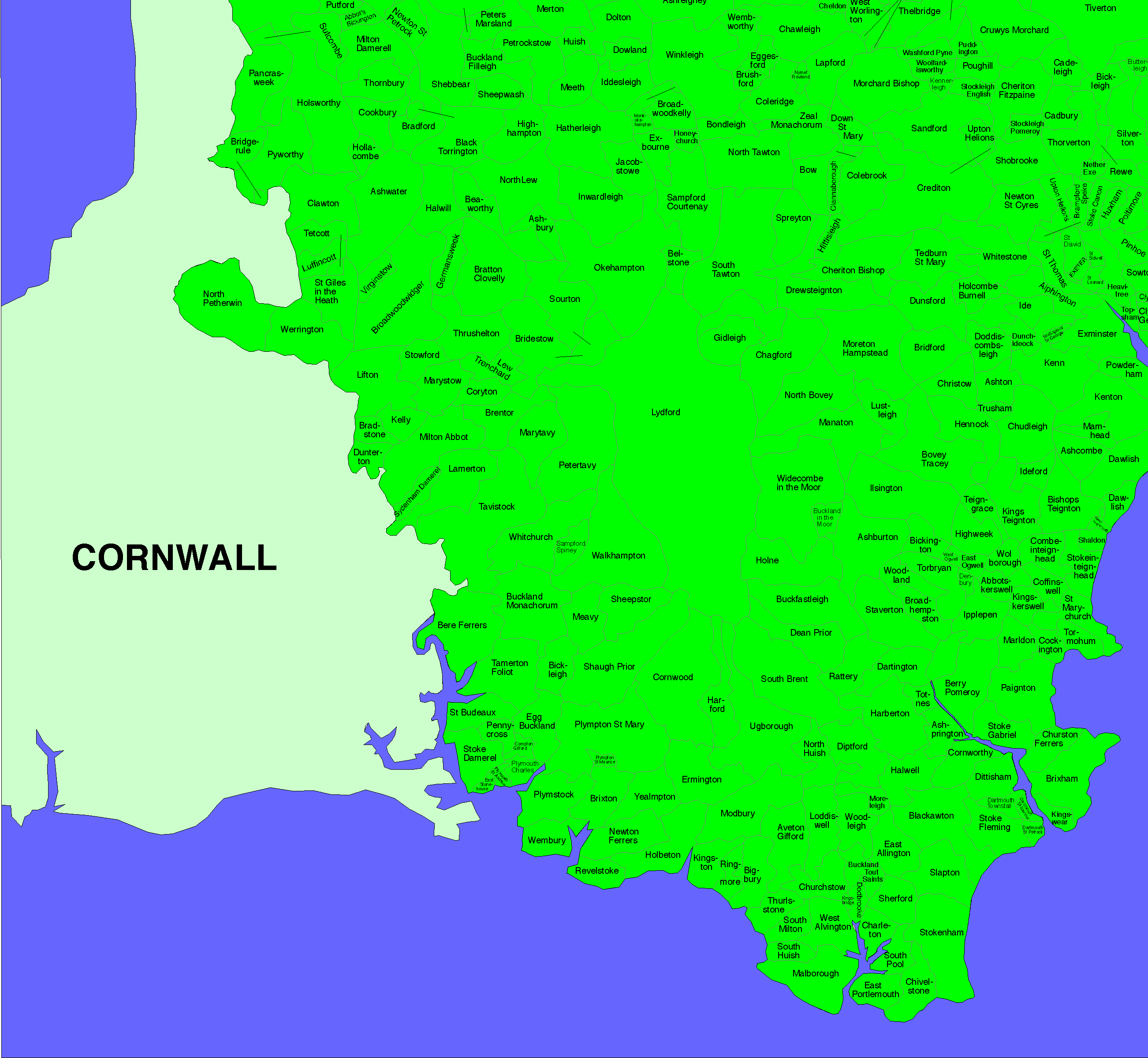
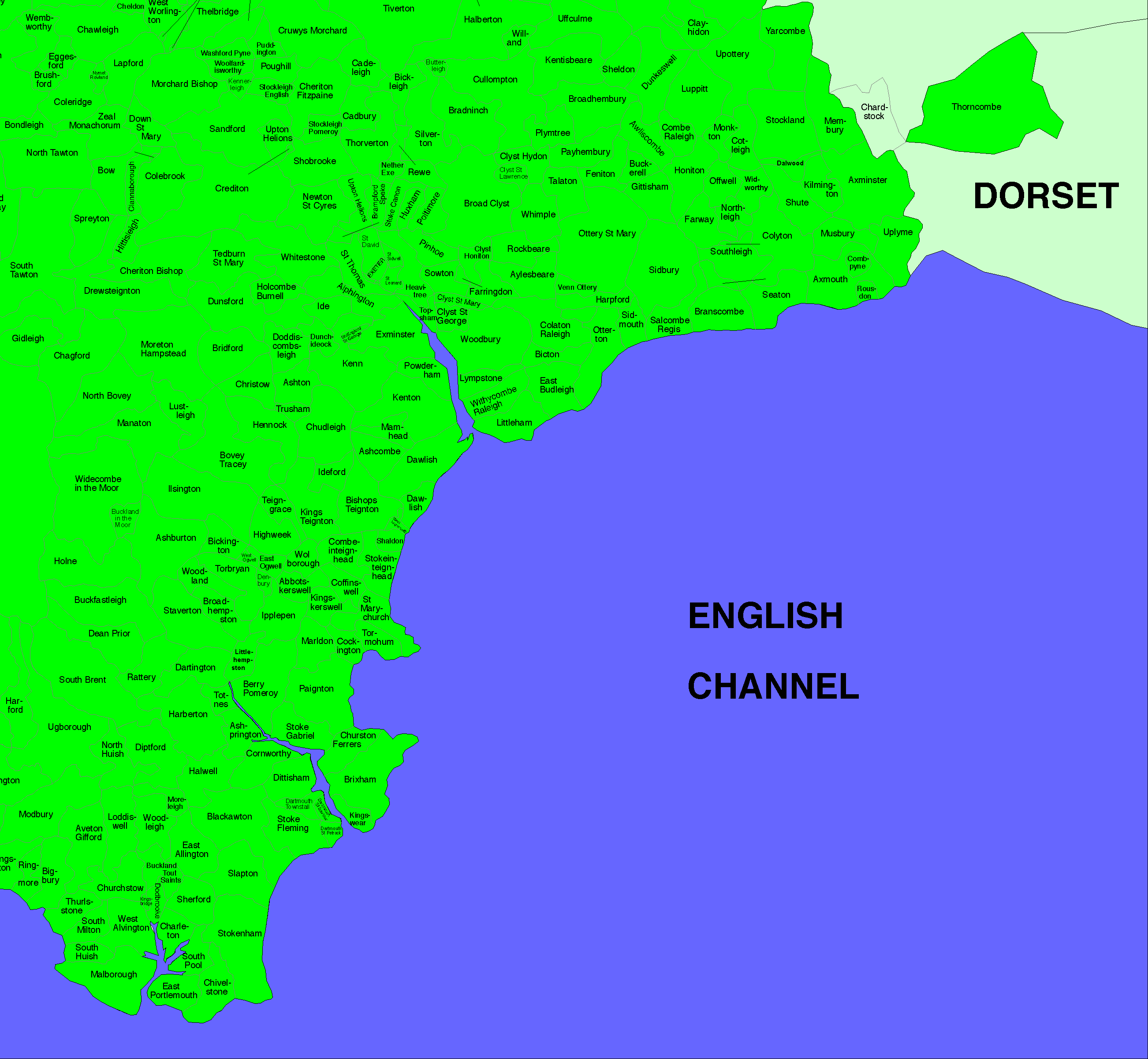
Outline Map of Devonshire, showing main towns and parish boundaries.
Devon FHS's Devon Parish Finder Map.
Schematic large-scale maps of Devon showing (ancient) parish boundaries:
Detailed maps from the 1885 Report of the Boundary Commissioners: Northern Section, Southern Section, and Eastern Section, showing boundaries of Parliamentary Boroughs, Petty Sessional Divisions, and proposed Parliamentary Divisions.
High definition scans of the entirety of Benjamin Donn's 1765 Map of Devon, from Wikipedia.
North Devon section of Benjamin Donn's 1765 Map of Devon. (272kb)
A very clear and detailed map of (South) Devon 1883/4, is provided by Nicolas Adams.
Devon in 1840 - a series of maps, redrawn from tithe maps, with place-names added, are available from Martin Ebdon Maps. (As of April 2021 just North Devon is covered, using information from over 150 tithe maps.)
Devon County Council provides maps, covering the different areas of Devon, showing (modern) parish locations:
|
|
Devon section of Genmaps - David Bax's very useful collection of links to online versions of old maps.
Devon maps in the National Library of Scotland's collection of high quality digitizations of old maps of England and Wales. (You will need to close the Help page which automatically opens.)
The Tithe Maps of the East Devon AONB - a large set of high definition images, provided by the Parishscapes project.
Batten, K. and Bennett, F. The Printed Maps of Devon, Exeter, Devon Books (1996).
Batten, K. and Bennett, F. The Printed Maps of Devon (2nd edition), Exeter, Devon Books (2008) [Internet version].
Batten, Kit and Bennett, Francis. The Victorian Maps of Devon, Printed Maps 1838-1901, Exeter, Devon Books (2000) xxxvi + 196 pp.
Few, Janet. Martin Ebdon’s Historical ‘Devon in 1840’ maps, Devon Family Historian, vol. 179 (2021) p.42. [A review]
Greenwood, C & J. Map of the county of Devon from an actual survey made in the years 1825 & 1826 [CD-ROM.], by . Facsimile of 1827 vol. [SoG Library CD-ROM cabinet (DE/GEN)]
Jerrett, Beth. Know Your Place West of England - Putting Devon on the Map, Devon Family Historian, vol. 167, (2018) pp.29.
Kain, Roger and Ravenhill, William. Historical Atlas of South-West England. Exeter University Press (1999) 584p. 395 maps, 150 ill. [ISBN: 0 85989 434 7]
["This is the first historical atlas of a major region of the United Kingdom. Its aim is to create and communicate the history of the south-western peninsula of England-Cornwall, Devon and the Isles of Scilly-from the beginnings of man's occupation to the present day. The cartographic message projected by around 400 maps is extended by a substantial text of about 250, 000 words as well as diagrams, contemporary prints and photographs."]
Ravenhill, Mary R. and Rowe, Margery M., (Ed.). Early Devon Maps: maps of lands and estates in Devon before 1700, Exeter, Devon Books (2000) vi, 58 pp.. ill. (chiefly col.). maps (chiefly col.) [ISBN: 1855227282].
Ravenhill, Mary R. and Rowe, Margery M., (Ed.). Devon Maps and Mapmakers: Manuscript maps before 1840, Exeter, Devon & Cornwall Record Society (2002) 2 vols. [ISBN: 0901853433] [Devon FHS Library 912.435].
Ravenhill, Mary R. and Rowe, Margery M., (Ed.). Maps of Georgian Devon, Friends of Devon Archives (2003) [ISBN 1-85522-857-2].
Devon 1827 - Greenwoods Maps Surveyed 1825/6 - 1" to 1 mile. CD 0292, ArchiveCD (2001).
County Maps - Cornwall, Devon, Somerset & Dorset ArchiveCD (2003). [Devon county maps 1695, 1831, 1837, 1844]