
Hide
Monkton
Hide
Maintainers
The updates have been applied on the "anchor" issue on 27 July.
The issues are discussed here
Details are also on the maintainers list.
hide
Hide
hide
- Almanacs◬
- Archives & Libraries◬
- Bibliography◬
- Biography◬
- Business & Commerce Records◬
- Cemeteries
- Census◬
- Chronology◬
- Church History◬
- Church Records
- Churches
- Civil Registration◬
- Correctional Institutions◬
- Court Records◬
- Description & Travel
- Directories◬
- Emigration & Immigration◬
- Encyclopaedias & Dictionaries◬
- Folklore◬
- Gazetteers
- Genealogy◬
- Handwriting◬
- Heraldry◬
- Historical Geography◬
Hide
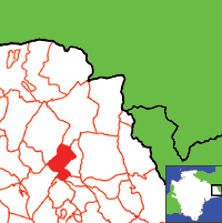
Click on map to view parish boundaries in detail.
Hide
Hide
hide
- History
- Jewish History◬
- Land & Property◬
- Language & Languages◬
- Manors◬
- Maps
- Medical Records◬
- Merchant Marine◬
- Military History◬
- Names, Geographical◬
- Names, Personal◬
- Newspapers◬
- Occupations◬
- Periodicals◬
- Politics & Government◬
- Poor Houses, Poor Law◬
- Population◬
- Probate Records◬
- Schools◬
- Social Life & Customs◬
- Societies◬
- Taxation
- Voting Registers◬
Hide
"MONKTON is a small picturesque village and parish on the south bank of the river Otter, and on the high road from Honiton to Taunton and Ilminster, 2 miles north-east from Honiton station on the main line of the London and South Western railway, 18 north-east from Exeter and 16 south from Taunton, in the Eastern division of the county, Colyton hundred, Honiton petty sessional division, union and county court district, rural deanery of Dunkeswell and Honiton and archdeaconry and diocese of Exeter. The church of St. Mary Magdalene, excepting the tower, was entirely rebuilt of stone in 1862, in the Norman style . . . there are 130 sittings. The register of baptisms dates from the year 1737; marriages, 1742; burials, 1741. . . . The chief crops are wheat, oats and turnips. The acreage is 1,441; rateable value £1,540; the population in 1891 was 129 in the civil and 109 in the ecclesiastical parish." [From: Kelly's Directory of Devonshire, 1902]
A parish in Colyton Hundred, a Peculiar of the Dean and Chapter of Exeter.
Hide
MIs for this parish are included in the Incledon index - see under Cemeteries on the main Devon page.
Parish Registers going back to 1737 are held in the Devon Record Office.
The Devon FHS publishes indexes covering (as of June 2004): Marriages 1754-1837 - for details see their Devon Parish List.
Nothing entered into the IGI (as of Jan 1993).
The Deanery of Honiton: CD-ROM CD041, Exeter, Devon FHS (2013). [Axminster Bapt: 1813-1840, Mar: 1754-1837, Bur: 1813-1837; Axmouth Bapt: 1813-1840, Mar: 1603-1837, Bur: 1813-1837; Chardstock Bapt: 1813-1839, Mar: 1754-1837, Bur: 1813-1837; Colyton Bapt: 1813-1839, Mar: 1538-1837, Bur: 1813-1837; Combpyne Bapt: 1813-1839, Mar: 1757-1836, Bur: 1796-1847; Cotleigh Bapt: 1813-1839, Mar: 1754-1837, Bur: 1813-1837; Dalwood Bapt: 1813-1840, Mar: 1754-1837, Bur: 1813-1837; Farway Bapt: 1813-1840, Mar: 1754-1837, Bur: 1800-1837; Gittisham Bapt: 1813-1839, Mar: 1754-1838, Bur: 1800-1837; Hawkchurch Bapt: 1813-1839, Mar: 1754-1837, Bur: 1813-1838; Honiton Bapt: 1813-1839, Mar: 1754-1837, Bur: 1813-1837; Honiton Ind, Bur: 1774-1837; Kilmington Bapt: 1813-1839, Mar: 1754-1837, Bur: 1813-1837; Membury Bapt: 1813-1840, Mar: 1754-1837, Bur: 1813-1837; Monkton Bapt: 1813-1839, Mar: 1754-1837, Bur: 1814-1842; Musbury Bapt: 1813-1839, Mar: 1754-1837, Bur: 1813-1837; Northleigh Bapt: 1813-1839, Mar: 1756-1836, Bur: 1813-1837; Offwell Bapt: 1813-1839, Mar: 1754-1837, Bur: 1800-1837; Seaton & Beer Bapt: 1813-1839, Mar: 1754-1839, Bur: 1813-1837; Shute Bapt: 1813-1840, Mar: 1754-1837, Bur: 1813-1837; Southleigh Bapt: 1813-1839, Mar: 1756-1837, Bur: 1800-1837; Stockland Bapt: 1813-1840, Mar: 1640-1837, Bur: 1813-1837; Thorncombe Bapt: 1813-1837, Mar: 1754-1837, Bur: 1813-1841; Uplyme Bapt: 1813-1839, Mar: 1754-1838, Bur: 1813-1837; Wambrook Bapt: 1813-1904, Mar: 1754-1836; Widworthy Bapt: 1813-1840, Mar: 1754-1954, Bur: 1790-1837.]
Section on Monkton from Samuel Lewis: A Topographical Dictionary of England (1831), provided by Mel Lockie.
The transcription of the section for this parish from the National Gazetteer (1868), provided by Colin Hinson.
- Ask for a calculation of the distance from Monkton to another place.
View a map of the boundaries of this town/parish.
You can see maps centred on OS grid reference ST187031 (Lat/Lon: 50.821713, -3.155554), Monkton which are provided by:
- OpenStreetMap
- Google Maps
- StreetMap (Current Ordnance Survey maps)
- Bing (was Multimap)
- Old Maps Online
- National Library of Scotland (Old Ordnance Survey maps)
- Vision of Britain (Click "Historical units & statistics" for administrative areas.)
- English Jurisdictions in 1851 (Unfortunately the LDS have removed the facility to enable us to specify a starting location, you will need to search yourself on their map.)
- Magic (Geographic information) (Click + on map if it doesn't show)
- GeoHack (Links to on-line maps and location specific services.)
- All places within the same township/parish shown on an Openstreetmap map.
- Nearby townships/parishes shown on an Openstreetmap map.
- Nearby places shown on an Openstreetmap map.
Hoskins, W.G. Extracts from the lay subsidy rolls...for the parishes of Luppitt [1591, 1660], Cotleigh [1660], Monkton [1660], Shute [1660], Northleigh [1660], Farway [1660] and lists of the inhabitants of the precinct of Bradninch in Exeter, 1708, 1732, 1752, Manuscript (1935). [D&CRS Library, Exeter: P1660]