
Hide
St John the Evangelist, Bacup, Church of England
Hide
Maintainers
The updates have been applied on the "anchor" issue on 27 July.
The issues are discussed here
Details are also on the maintainers list.
hide
Hide
Hide
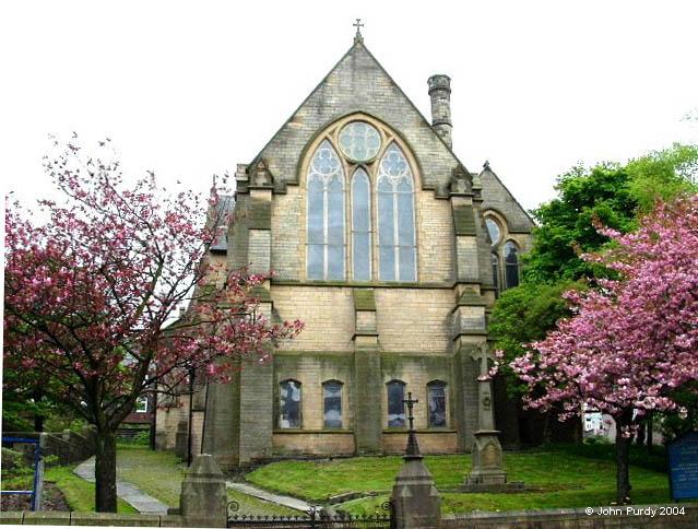
St John the Evangelist,
Burnley Road,
Bacup
Lancashire
Hide
It was founded in 1788. It had closed by 2013.
The Anglican Church of St. John the Evangelist on Burnley Road has been Bacup's Parish Church since 1837. The present building has something of an unusual floor, as it slopes markedly down from the back of the Church towards the alter. It opened for worship in 1883 and stands on the site of the original Church premises which partially collapsed in 1871 due to serious structural defects.
In fact the old building had been unsafe for many years before that, being described at the time as 'being in a most dilapidated condition and almost roofless'. Old photographs show strong timbers propping the walls! Occasionally referred to by earlier generations in a broad Lancashire dialect as 'Th'owd Parish Church' (The Old Parish Church), the original building was the first Anglican Church in Bacup and dated from 1788. By the time of its' collapse, there had been more than 7,000 burials in the Churchyard.
In a census of Church attendance on 22nd January 1887, four years after the new Church opened, 616 worshippers were recorded at St. John's.
This site provides historical information about churches, other places of worship and cemeteries. It has no connection with the churches themselves. For current information you should contact them directly.
Baptisms
1788-1812
Transcript of baptisms 1788-1812 by the Lancashire Parish Register Society - Volume NC05
1793-1846
Marriages
1788-1812
Transcript of marriages 1788-1812 by the Lancashire Parish Register Society - Volume NC05
1793-1837
Burials
1788-1812
Transcript of burials 1788-1812 by the Lancashire Parish Register Society - Volume NC05
1793-1846
- OpenStreetMap
- Google Maps
- StreetMap (Current Ordnance Survey maps)
- Bing (was Multimap)
- Old Maps Online
- National Library of Scotland (Old Ordnance Survey maps)
- Vision of Britain (Click "Historical units & statistics" for administrative areas.)
- English Jurisdictions in 1851 (Unfortunately the LDS have removed the facility to enable us to specify a starting location, you will need to search yourself on their map.)
- Magic (Geographic information) (Click + on map if it doesn't show)
- GeoHack (Links to on-line maps and location specific services.)