
Hide
Bellingham
hide
Hide
hide
Hide
Hide
Hide
"BELLINGHAM parish is composed chiefly of moors and sheepwalks, and was formerly a chapelry to the extensive parish of Simonburn, which was divided into six parishes by an act of the 51st of George III., cap. 194. It comprises the townships of Bellingham, East Charlton, West Charlton, Leemailing, Nook, and Tarretburn, whose united area is 20,211 acres. The population in 1801, was 1,079; in 1811, 1,232; in 1821, 1,396; in 1831, 1,460; in 1841, 1,730; and in 1851, 1,594 souls. In this parish there is a extensive moor, called Hareshaw Common, containing above 7,000 acres, and abounding in various kinds of game. The soil, both in the valleys and on the hill side, is very fertile, being a strong red gravel, producing abundance of corn and turnips. Coal, ironstone, and limestone are found in large quantities in this district." [From History, Topography, and Directory of Northumberland, Whellan, 1855].
Hide
- Some fascinating early 20th century photographs of the North Tyne area have been published in:- "North Tyneside Traveller 1912-1937 - The Photographs of W.P. Collier of Bellingham" edited by S.F.Owen and published in 1998 by The Heritage Centre, Bellingham, Northumberland, NE48 2AU
- A History of Northumberland by John C Hodgeson vol 15 includes Bellingham
- Bellingham, North Tynedale and Redesdale, a collection of photographs compiled by Ian Roberts and Moira West 1998
- Village photograph, photographs of W.P. Collier of Bellingham compiled by S F Owen n.d.
- Bellingham Northumberland, Editor Laurie Felicie 2010
Sir David Lindsay Kier, 22 May 1895 - 2 October 1973 Historian and Academic Born in Bellingham the eldest of six children, his father was a Prebyterian Minister from Aberuthven, Scotland.
- Burial Registers 1896-1994, Grave Spaces Register 1896-1994 and Grave Plan 1896-1994 for Bellingham Civil Cemetery are available at Northumberland Record Office
- Northumberland County Record Office hold copies of Census Returns 1841 - 1891 and produce a useful User Guide
- The 1851 Census Index (microfiche CN20)
- The 1891 Census for Northumberland – Bellingham, Smalesmouth, Chirdon, Wellhaugh and Plashetts (PRO piece RG12/4252) (Type B) (Book) (Volume 62) BOTH published by the https://www.ndfhs.org.uk/ may be of value to researchers interested in this parish.
- The 1851 census index vol 37 includes Bellingham at the Local Studies Centre, Newcastle City Library [shelf ref; LRS]
- An Index to the 1851 census for Bellingham Castle Ward Ponteland Haltwhistle and Hexham produced by P.R.G. Thirkell is available to view in the Local Studies Section of Newcastle City Library they also produce a very useful User Guide on Census Records www.newcastle.gov.uk/leisure-libraries-and-tourism/libraries/local-studies-and-family-history
- Bellingham - Church Records - links and information.
- Bellingham Roman Catholic Baptisms 1794-1925 published by Northumberland County Record Office, 1997 available at the Local Studies Centre Newcastle City Library [shelf ref; L929.3 B444]
- This area is within Northumberland West Registration District.
- Certificates of birth, death and marriage can be ordered from Northumberland County Council.
- Photographs of Bellingham from Les Bell's Northumberland Cam website.
- The Northumberland Communities website includes pages relating to Bellingham. They provide "a range of learning resource material that reflects Northumberland's heritage, providing a base for studying the County's history. The website provides a starting point for understanding the development of communities in Northumberland. It also seeks to illustrate the range of sources for family and local history research that are available via Northumberland Archives Service."
- The section of The National Gazetteer (1868) relating to this parish - transcribed by Colin Hinson.
- Ask for a calculation of the distance from Bellingham to another place.
- A history of the village of Greenhaugh from the Northumberland National Park website.
- The history of Bellingham Parish is included in:- Northumberland County History Committee, History of Northumberland, Volume 15. Newcastle, A. Reid, 1940. (Available on fiche from Ancestral Indexes).
- LNER Wartime Evacuation Documents N.EVAC 2 and N.EVAC 3 describing the arrangements for evacuating children from Newcastle and Gateshead to rural parts of Northumberland (including Bellingham), Co Durham, Yorkshire, Cumberland and Westmorland. The second document includes lists of schools with details of their places and times of departure and their destinations.
- https://bellingham-heritage.org.uk/ has exhibitions on the Photographs of W.P. Collier, the Border Counties Railway, The Border Reivers and Mining Heritage, and, for visitors to the centre only, there is a searchable database of 38,000 names from parish and other records.
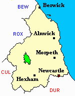
- Bellingham - Maps - links and information.
You can see maps centred on OS grid reference NY824888 (Lat/Lon: 55.193031, -2.277217), Bellingham which are provided by:
- OpenStreetMap
- Google Maps
- StreetMap (Current Ordnance Survey maps)
- Bing (was Multimap)
- Old Maps Online
- National Library of Scotland (Old Ordnance Survey maps)
- Vision of Britain (Click "Historical units & statistics" for administrative areas.)
- English Jurisdictions in 1851 (Unfortunately the LDS have removed the facility to enable us to specify a starting location, you will need to search yourself on their map.)
- Magic (Geographic information) (Click + on map if it doesn't show)
- GeoHack (Links to on-line maps and location specific services.)
- All places within the same township/parish shown on an Openstreetmap map.
- Nearby townships/parishes shown on an Openstreetmap map.
- Nearby places shown on an Openstreetmap map.
- Bellingham Parish was part of Bellingham Poor Law Union. The Union Workhouse was located in the town of Bellingham. Some records are held at Northumberland Record Office but these are of limited genealogical value.
St Cuthberts Well, or Cuddys well, situated near the 11th Century church and has three miracles connected to it each revolving around a man named Sproich and his daughter Eda. The well now runs through a Georgian culvert or Pant and the water is still used in baptism ceremonies