Hide
Barony
hide
Hide
hide
Hide
hide
Hide
Hide
"BARONY, locating Barony on a map can be a somewhat perplexing business - for you will almost certainly fail to locate it on any modern map! Today, what was Barony parish has long been eaten up by the city of Glasgow. In the past it represented lands which were to the north of the city and which were, in those days, more rural - they included Maryhill, Lambhill, Bishopriggs, Kelvinside, Possil, Balornock, Springburn, Provanmill, Millerston, Dennistoun, Garthamlock, Carntyne, Calton, Barlanark, Shettleston, Tollcross and Barrachnie. (Some of these cross parish boundaries).
The one reminder of the name Barony is the former Barony Church, now Strathclyde University's Barony Hall, which is located directly opposite Glasgow Cathedral (see photograph below). "
Hide
| Barony, Church of Scotland |
Dates of Old Parish Registers
b.1672-1854
m.1672-1854
d.1805-1835
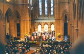
The former Barony Church, pictured below, is now Strathclyde University's Barony Hall and is their main hall for Graduation ceremonies.

Pictured is a Congregation gathered to witness one such ceremony.
A description of Barony from Groome's Ordnance Gazetteer of Scotland, 1892-96.
- Ask for a calculation of the distance from Barony to another place.
The Statistical Account for Scotland, Barony Parish published in 1799 (written about 1791 to 1798) has been transcribed by Linda Nisbet from New Zealand.
You can see maps centred on OS grid reference NS592666 (Lat/Lon: 55.872017, -4.252396), Barony which are provided by:
- OpenStreetMap
- Google Maps
- StreetMap (Current Ordnance Survey maps)
- Bing (was Multimap)
- Old Maps Online
- National Library of Scotland (Old Ordnance Survey maps)
- Vision of Britain (Click "Historical units & statistics" for administrative areas.)
- Magic (Geographic information) (Click + on map if it doesn't show)
- GeoHack (Links to on-line maps and location specific services.)
- All places within the same township/parish shown on an Openstreetmap map.
- Nearby townships/parishes shown on an Openstreetmap map.
- Nearby places shown on an Openstreetmap map.
