
Hide
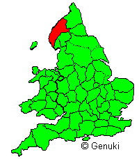
Cumberland
hide
Hide
hide
- Archives & Libraries
- Bibliography
- Biography
- Business & Commerce Records◬
- Cemeteries
- Census
- Chronology◬
- Church History
- Church Records
- Civil Registration
- Correctional Institutions
- Court Records
- Description & Travel
- Directories
- Emigration & Immigration◬
- Gazetteers
- Genealogy
- Historical Geography
- History
- Land & Property
- Language & Languages
- Law & Legislation◬
- Manors
Hide
Hide
Hide
hide
- Maps
- Medical Records
- Merchant Marine◬
- Migration, Internal◬
- Military History
- Names, Geographical
- Names, Personal◬
- Newspapers
- Occupations
- Politics & Government◬
- Poor Houses, Poor Law
- Population
- Probate Records
- Public Records◬
- Religion & Religious Life
- Schools
- Social Life & Customs
- Societies
- Statistics◬
- Taxation
- Town Records◬
- Voting Registers
Hide
The information on this page, and on the accompanying Town & Parish pages is organised by the set of subject headings that the LDS Family History Library use for categorising genealogical research material. Above are the available headings for Cumberland; but see How the information on this server is presented to the user for further details, and for an overall list. [Hint: Press the "Back" arrow on your browser's toolbar to return to this page after reading, as there is no return link.]
"CUMBERLAND, A maritime and border county of England [Map (above) shows location], having the counties of Dumfries and Roxburgh on the north, Northumberland and Durham on the east, Westmorland and Lancashire on the south, the Irish Sea on the west, and the Solway Firth on the NW.; length, NE. and SW., 75 miles; extreme breadth, E. and W., 45 miles; average breadth, 22 miles; coast line, about 75 miles; area, 970,161 acres, population 250,647. The coast on the Solway is low and sandy, but on the Irish Sea it is lofty and rugged; chief promontory, St Bees Head. In the NW. the country is open and flat; it is watered by the Eden and other streams, and consists chiefly of verdant meadows and good arable land. From this plain the surface rises towards the east and south into a region with deep defiles or dales, which form the mountainous district of "The Lakes". Coal and iron are extensively worked in the west, the coalfield stretching from the neighbourhood of Whitehaven to that of Maryport. Numerous blast furnaces are constantly at work. Plumbago or black lead is obtained in considerable quantities near Keswick. Slate, limestone, and sandstone are abundant. Copper, cobalt, antimony, manganese, and gypsum are also found. Owing to the general elevation of the land, and the moisture of the climate, the cultivation of the soil is less attended to than the rearing of sheep and cattle. The dairy produce is very considerable. Woollen manufactures are carried on to some extent at Carlisle and some other places The County comprises 5 wards, 208 parishes, the parliamentary and municipal borough of Carlisle (1 member), and the parliamentary borough of Whitehaven (1 member). It is mostly in the diocese of Carlisle. For parliamentary purposes it is divided into 4 divisions, viz., Northern or Eskdale, Mid or Penrith, Cockermouth, and Western or Egremont, 1 member for each division."
[Extract from Bartholemew's Gazetteer of the British Isles, 1887]
Between 1974 and 2023, Cumberland was incorporated into the county of Cumbria together with Westmorland, the Furness part of Lancashire and a small part of the former West Riding of Yorkshire around Sedbergh. From 2023, Cumbria is split into 2 unitary authorities, one of which is Cumberland being the one which includes the historic county (though excluding the Penrith district).
Genuki continues to organise information for the ceremonial or historic county of Cumberland, and local information is organised by parishes as they existed in the C19th (according to the Phillimore Atlas and Index of Parish Registers 2nd ed., Chichester, Phillimore (1995).
Hide
Cumberland is still served by the Cumbria Archive Service and the principal for the county is Carlisle Record office
but there is much material for the West of the County at Whitehaven Record Office
However there will also be some useful material at other record offices such as York (Borthwick Institute) and London (National Archives).
Other relevant material might be found at Barrow or Kendal or Preston
The Cumbria Archives catalogue is available online with guides for different record types.
This includes Cumberland Quarter Session records. Individual names are indexed.
The Lancashire Archives catalogue is also online, and for instance has over 34,000 catalogue references indexed as "Cumberland"
The National Archives Discovery catalogue indexes the holdings of the National Archives and 2500 other archives across the UK. There are over 51,000 catalogue references for "Westmorland" of which over 8900 are downloadable.
Genealogical material on Cumberland held in Carlisle Library (and also at Workington and Penrith) is described on the Cumbria Libraries Local Studies website.
The Society of Genealogists Library in London also has much useful material for members.
Cumberland - Genuki - Archives and Libraries - links and information.
The essential book for family historians is Cumbrian Ancestors 4th edition (2014) published by and available from Cumbria Archive Service.
Also Cumberland and Westmorland: a genealogical bibliography. Stuart Raymond. 1993. Published Federation of Family History Societies - ISBN 1 872094 56 2.
Cumberland books can be searched in the LDS FamilySearch Catalog to find those available on-line, in FamilySearch centres, or in the Library in Salt Lake City.
Much useful information can be found in Cumbria FHS Publications including many transcriptions for the 1851 census. There is an index to Newsletters.
The Cumberland and Westmorland Archaeological and Antiquarian Society (CWAAS) has listing of its publications and its invaluable Transactions. These latter can be downloaded by CWAAS members (those older than 5 years for non-members). Printed Transactions are held by several public libraries within Cumbria and elsewhere.
Google Books and Internet Archive (Open library) have thousands of digitised books with "Cumberland" in the title or text.
Dictionary of Cumbrian Lives on Cumbrian Lives
The worthies of Westmorland or, Notable persons born in that county since the reformation.
by George Atkinson. Published in 1849, J. Robinson (London), it is available as full-text on Internet Archive.
Worthies of Cumberland and Westmorland on Steve Bulman's site.
Biographies of Notable people on Wikipedia
Other listings and biographies on Wikipedia
List of Lord Lieutenants for Cumberland
List of High Sheriffs for Cumberland
Custos Rotulorum of Cumberland - Keepers of the Rolls
List of MPs for Cumberland constituency
Cumberland and Westmorland M.P.'s from the Restoration to the Reform Bill of 1867, 1660-1867.
by Richard Saul Ferguson Published in 1871, Bell 2nd Daldy (London) available full-text on OpenLibrary.
The ejected of 1662 in Cumberland and Westmorland their predecessors and successors.
by Nightingale, B. Published in 1911, Univ. Press (Manchester) is available on Open Library.
There is a guide to Burial Authorities (including Burial/Cemetery Board and Local Authority cemetery records) at Cumbria Archives
Booklets and downloads of Monumental Inscriptions in churchyards transcribed by Cumbria FHS are available from their online shop
Returns for the national censuses of 1841 to 1921 are available online/on microfilm from the usual libraries, including Carlisle Library.
They are searchable online by subscribers e.g. through Ancestry and FindmyPast, or for a fee. and can be accessed for a fee.
A useful summary of access is provided on the National Archives website for all available censuses and also for the 1939 Register
The England & Wales 1881 census is freely available, including images (and also free indexes for 1841-1911) on the LDS familysearch site,
and is also available on computer and microfiche at Mormon Family History Centres and other libraries, and also available for purchase on CD-ROM.
Much of the 1851 census has been transcribed by Cumbria FHS and booklets can be purchased from the CFHS website shop .
Names appearing in these transcripts are available in a name index (incomplete) provided by Roland Grigg (web archive)
For places on the 1851 census see the place index by Roland Grigg.
The free database FreeCen allows searching of over 424,000 transcripts for Cumberland for 1861-91
Cumberland Genuki Census - links and information.
County Churches: Cumberland and Westmorland by J. Charles Cox
Published in 1913, G. Allen & company, ltd. (London) is available on archive.org
Cumbrian Parishes 1714 - 1725 from Bishop Gastrell's Notitia. Dr Lawrence A.S. Butler
For brief descriptions see under the parish concerned, but for detailed descriptions see:
- Salter M. The Old Parish Churches of Cumbria. Folly Publications. 1998. ISBN 1871371356
- Pevsner N. The Buildings of Cumberland and Westmorland. 1967.
A comprehensive coverage of Westmorland churches and chapels is available on the GENUKI church database.
Many church photographs are available via the parish pages on this site.
There is also the discontinued Steve Bulman's Images of Cumbria and churches sites (not just Westmorland)
and selected ones included in Visit Cumbria's Churches of Cumbria
ICBS Church plans (mostly C19th) from Lambeth Palace Library Collections (Incorporated Church Building Society) are available online.
There is an online Guide to Church Records for Cumbria made available by the Archive Service, including
Parish Registers will usually be in the Carlisle Record office, as will the Bishop's Transcripts.
Listings have been published by Cumbria Archives (which will confirm which office will hold the originals)
- Cumbrian Church of England parish registers (PDF, 348KB)
- Cumbrian Methodist circuit and chapel registers (PDF, 141KB)
- Cumbrian church and chapel registers: Roman Catholic, Presbyterian, Congregational, Friends/Quakers, other non-conformist (PDF, 123KB)
Microfilm versions should also be available through LDS Family History Centres. Use the normal sources for indexes and obtaining microfilms.
In particular the International Genealogical Index (IGI) is available on the Mormon LDS Church FamilySearch site.
Cumberland parishes are searchable via:
- Cumbria FHS search interface (accessed by parish map).
- Archer Software IGI Batch Numbers.
- Hugh Wallis' interface on Rootsweb.
FamilySearch also have Cumbria Parish Registers, 1538-1990 available online. The coverage January 2023 was
| County | Baptism | Marriage | Burial |
|---|---|---|---|
| Cumberland | 181,993 | 72,938 | 120,152 |
There is a more detailed coverage table.
The registers for some Cumberland parishes are included in a parish register index by Roland Grigg (Internet Archive).
Some are available on Edenlinks now on Cumbria FHS site.
In Cumberland the Joiner Marriage Index currently has 30,822 marriage records to search in 32 parishes between 1539 and 1838.
The Society of Genealogists web site has a list of their holdings of Parish Register Copies for Cumberland.
Transcriptions of a selection of Cumberland parish records are available from the "Cumberland Roots" website (archived site).
All known transcriptions will eventually be indicated from the respective parish page here on GENUKI Cumberland.
Diocese of Carlisle Marriage License/Bonds are at Carlisle RO and have been published by Cumbria FHS/Cumbria Archive service in 6 volumes:
1 (1668-1739), 2: 1740-1752, 3: 1753-1762, 4: 1763-1774, 5: 1775-1788, 6: 1789-1800.
available for purchase from CumbriaFHS shop
Non-conformist registers are usually deposited at the PRO in London. Microfilm copies for many are available in the Kendal Record Office.
Details of Society of Friends records are given on the Cumbria Archive site
Information on the location of Quaker Records in Cumberland provided by the Quaker FHS
|
FS Wiki |
|||||||||
|
IGI batch numbers on Rootsweb (Hugh Wallis) can be used to search directly in FamilySearch.
The FamilySearch ResearchWiki page also indicates coverage on other resources, including paying and subscription access genealogical platforms. |
|||||||||
General details on registration of births, marriages and deaths and their indexes are provided on the GENUKI England site.
The indexes can be searched free of charge on FreeBMD (limiting if wished to Cumberland or specific registration district)
Brett Langston has provided details of Westmorland Registration Districts 1837-1930.
For known Births and Deaths, more information can be found on the GRO Online Indexes website.
Certificates of birth, death and marriage can be obtained from the Cumbria Certificate Service.
Carlisle City and County Gaol is described on PrisonHistory
There are Guides and Catalogue links from Cumbria Archive Service for
The place-names of Cumberland and Westmorland by Sedgefield, Walter John, published in 1915, University Press (Manchester) is available as full-text from Open Library.
Historical Guides to the Lakes and a collection of historical prints are available on a LakesGuides (site formerly by the Geography Department, Portsmouth University)
Black's Guide to the English Lakes of Cumberland and Westmorland by Blacks, Edinburgh is available in Open Library.
Legends of Westmorland and the Lake district. Published in 1874, Hamilton, Adams, and Co.; [etc., etc.] (London) is available in Open Library.
Old photos of Cumberland are available on the Cumbrian page of the Francis Frith site.
Many present day photographs are available on Visit Cumbria.
Further Links to Cumberland, Lake District and Cumbria sites are provided on this site.
Cumbria and the Lake District Tourist Board.
- The EDGE Guide to Cumbria and the Lake District provides a wonderful overview of the area, including its history, sights, and many photographs.
A number of printed directories exist covering or including the county. There is an extensive collection in Carlisle Library
The Leicester University project Historical directories has facsimiles of a number of directories for the county.
These include:
- Pigot & Co.'s Directory of Ches, Cumb ..., 1828-29. [Part 1: Ches - Northumb]
- Baine History, Directory & Gazetteer of Cumberland & Westmorland, 1829
- Mannix History, Gazetteer & Directory of Cumberland, 1847
- Kelly's Directory 1858, 1873, 1894, 1897, 1906, 1910, 1914
- Bulmer History & Directory of West Cumberland, 1883, 1901
Parson & White's Directory for 1829 is indexed as Principal Inhabitants of Cumberland and Westmorland with Furness 1829, R. Grigg, Ed., Beewood Coldell, 1988 - ISBN: 1871418003
and still available on web archive: A | B | C | D | E | F | G | H | I | J | K | L | M | N | O | P | Q | R | S | T to V | W to Z
The details for all parishes from this directory are transcribed on Edenlinks site.
Harriet Martineau's Directory of the Lake District 1855 is transcribed by Roland Grigg (available through the Wayback Machine Internet Archive):
A to C | D to H | I to R | S to Z
These and several other Cumbrian directories have been combined on Roland Grigg's website (Internet Archive).
Cumberland is included in Pigot's Trade Directory 1830 searchable database hosted on Rootsweb..
- Extracts from Mannix & Whelan's Directory of 1847 and 1851 can be found on Steve Bulman's excellent Images of Cumbria website.
Use the national church database to identify a particular place in Westmorland (or to identify other places within a certain distance.
For places on the 1851 census see the place index by Roland Grigg.
Old Cumbria Gazetteer Lakes Guides (formerly Portsmouth Univ, Geography Dept.)
History of Cumberland - Placenames for the County is included on the Vision of Britain site.
Gazetteer of Markets and Fairs in England and Wales to 1516 compiled at the Centre for Metropolitan History
The Ordnance Survey site is useful for identifying and locating places.
Streetmap [for the whole of the UK] has a placename search facility for locating places
- Nigel Batty-Smith's site providing UK Genealogy Archives of Cumberland has a description of the county from The Comprehensive Gazetteer of England and Wales, 1894-5.
- The section of The National Gazetteer (1868) relating to Cumberland - transcribed by Colin Hinson.
- The transcription of the section for Miscellaneous Descriptions from the National Gazetteer (1868) provided by Colin Hinson. Included here are the descriptions of major topological features (rivers, hills &c.) and a descriptions of the county ward divisions.
- You may also find it worthwhile searching in the GENUKI Gazetteer. The GENUKI Gazetteer covers the whole of England, Wales and Scotland and can be searched by place-name (or part of a place-name) or Ordnance Survey Grid Reference (six-figure, eg NY390550). If there are multiple place-names matching the name you enter, you will be presented initially with a drop-down list of the matching place-names, and (when known), their nearest identifiable place.
Pedigrees recorded at the heralds' visitations of the counties of Cumberland and Westmorland
made by Richard St. George, Norry, king of arms in 1615, and by William Dugdale, Norry, king of arms in 1666
by Saint-George, Richard Sir Published in 1891, C. Thurman and sons (Carlisle) available in OpenLibrary.
Papers and pedigrees mainly relating to Cumberland and Westmorland, by William Jackson, published in 1892, Bemrose & sons, etc. (London), is available on Google Books.
There is a genealogy mail-list hosted by CumbriaFHS
There is an archive for former mail-list for Westmorland genealogy is hosted and archived by Rootsweb
- RootsChat Messaging Forum - Cumberland section.
- The Cumberland section of 'Curious Fox' - "The village-by-village contact site for anybody researching family history, genealogy and local history in the UK and Ireland".
- Details of Cumberland Mailing Lists.
The Earldom of Carlisle was partitioned into baronies. When the County of Cumberland was created, the baronies were subdivided as wards
- Allerdale above Derwent
- Allerdale below Derwent
- Eskdale
- Leath Ward
- Cumberland Ward
History and Antiquities of the Counties of Westmorland and Cumberland, by Joseph Nicolson and Richard Burn, 1777 is available from Google Books.
Bygone Cumberland and Westmorland. by Daniel Scott Published in 1899, W. Andrews & co. (London) available on Internet Archive.
Legends of Westmorland and the Lake district. Published in 1874, Hamilton, Adams, and Co.; [etc., etc.] (London) is available in Open Library.
Victoria County History draft township histories are available on the Cumbria County History Trust website
- A digital library of medieval and modern sources of the history of the British Isles - British History Online. Notable sources include Journals of the House of Commons and House of Lords, Fasti Ecclesiae Anglicanae, and the Victoria County History.
Feet of Fines - abstracts on medieval.org.uk giving details of conveyance of freehold property in Cumberland 1360-1485.
Farming - Landowners by Alan Postlethwaite on Industrial History of Cumbria
Listed Buildings on britishlistedbuildings.co.uk
- Some abstracts of Cumberland Feet of Fines (land conveyances) covering 1485-1509 - on Chris Phillips Medieval English Genealogy web site.
- Mike Durtnall is providing a country-wide collection of Historical Manuscripts Pages recording details of deeds that have been offered for sale on eBay and in auction catalogues. In most cases whereabouts of the documents will be unknown, but sufficient details of the property involved and of buyers, sellers, mortages, &c. is provided to make them a useful research tool.
Cumbrian Dialect on Wikipedia
Cumbric Language on Wikipedia
Information on manors is available on Lancaster University's Cumbrian Manorial Records website.
The Manorial Documents Register can be searched by selecting Westmorland as the county. As of November 2020, there were catalogued 3546 items, distributed between the many archives..
Most of the manorial records for the county will be found at Carlisle record offices, and hence catalogue references will be on the CASCAT database.
The Old Manorial Halls of Westmorland & Cumberland by Michael Waistell Taylor Published in 1892, T. Wilson is available on Open Library.
Links to web versions of maps of Cumberland and surrounding area from several centuries are provided on Lakes Guides (formerly Portsmouth Univ, Geography Dept.??)
Facsimiles of C19th Ordnance Survey maps of Cumberland are available on National Library of Scotland Maps site
A Boundary Commisioners' map of 1885 (Eyre & Spottiswoode) is available on the londonancestor.com site for Cumberland North and South
Current OS maps are available on the Ordnance Survey site (needs registration)
- British History Online - Ordnance Survey 1:10,560 Maps - The County Series of Ordnance Survey maps for Great Britain. Begun in 1840, this is the first comprehensive historic mapping of England, Scotland and Wales.
- Access to various satellite map sites (Google, MS Live, &c.) via the convenient front end of Zoom Earth.
- The London Ancestor site has maps from the 1885 Boundary Commissioners report for all parts of the British Isles, including Cumberland [Northern section] and Cumberland [Southern section] (Eyre and Spottiswoode, 1885)
- Kain, R.J.P., Oliver, R.R., Historic Maps of England and Wales: Boundaries before 1850. Previously available for purchase on CDROM - link provided for reference.
- The Old Maps web site has a wonderful series of 1:10,560 scale historical maps for the whole of the UK available on-line.
- Genmaps - a collection of 'Old and Interesting Maps of England, Wales and Scotland' for Genealogists and Historians.
- The above Genmaps Links pages lists Great Britain - Medieval Maps, which in turn provides several maps including an intriguing Ecclesiastical Map of the British Isles in the Middle Ages, which shows the principal Monasteries, demonstrating some of the earliest centres of habitation and influence.
- Detailed Maps of the area you may be interested in Cumberland/Cumbria are viewable at the UK Street Map Page. The site provides a most useful service, with superb address searching and street map facilities for anywhere in mainland Great Britain.
- Medical Heritage of Great Britain- a site produced by the Bath & Wessex Medical History Group, providing detailed information on a county level of the history of medical treatments, and locations of some associated buildings.
Hospitals - catalogue and guides on Cumbria Archive Service website
- Two very comprehensive sites featuring Castles and Fortifications - CastleUK.net
- Names from Musters of the Cumberland Militia 1781-82 are available for purchase on floppy disk or microfiche through Family History Indexes (the link to Militia Musters is part way down the page).
- Roll of Honour - Cumberland - War Memorial Selection.
- Brian Pears has provided two LNER Wartime Evacuation Documents (N.EVAC 2 and N.EVAC 3) describing arrangements for evacuating children from Newcastle and Gateshead to rural parts of Northumberland, Co Durham, Yorkshire, Cumberland and Westmorland. The second document includes lists of schools with details of their places and times of departure and their destinations.
Cumberland Place-names on English Place-Name Society site
Place-names of Cumberland and Westmorland 1915 Internet Archive (Open Library)
Cumbrian Toponymy on Wikipedia
Top surnames from the 1881 census in Westmorland are found on britishsurnames.co.uk
Surname frequency data is available in Cumbrian Surnames Part 1 and Part 2.
| Newspaper Name | Place of publication | BL Holdings |
| Cumberland & Westmorland Herald.- archive website | Penrith | 1925 to date |
| Cumberland and Westmorland Advertiser and Penrith Weekly Chronicle | Penrith | 1855-1898 |
| Cumberland and Westmorland Advertiser, and Penrith Literary Chronicle. | Penrith | 1854-1855 |
| The Lake District Herald, etc. | Penrith | 1920 to date |
| Mid Cumberland and North Westmorland Herald | Penrith | 1891-1925 |
| Penrith Herald, and East Cumberland and Westmorland News | Penrith | 1869-1891 |
| Penrith and District Times. | Penrith | 1898-1898 |
| Penrith Times and Cumberland and Westmorland Advertiser. | Penrith | 1898-1901 |
An extensive list of Cumbria Libraries Newspaper Collections and their holdings is available from Cumbria County Council's site
The British Newspaper Archive (articles downloadable for a fee) includes Westmorland newspapers in the British Library collection.
A list is published by CWAAS: A Hand-list of newspapers published in Cumberland, Westmorland & North Lancashire. By F. Barnes & J.L. Hobbs (1951, PB, ISBN 1 873124 07 0).
Transcribed items are being added to Cumberland and Westmorland Newspaper Transcriptions.
- For other English Newspapers see OnlineNewspapers.com - England.
A table of occupations1841 recorded in the census is available on Vision of Britain
Agricultural labourer was the most prevalent.
There is a Guide to holdings on Poor Law Unions in the Cumbria Archive Service
Descriptions of Poor Law Unions and Workhouses for Alston with Garrigill, Bootle, Carlisle, Cockermouth, Longtown, Penrith, Whitehaven and Wigton
are available on workhouses.org.uk
Archived information is also available for Cumberland Workhouses from institution.org.u
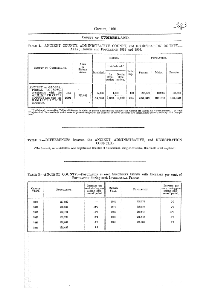
Table of population at each successive census 1801-1901 is given on Online Historical Population Reports
There are guides:
- Westmorland Probate Records on FamilySearch
- Cumbrian Wills and Probate Records on Cumbrian Archive Service
Most wills for the North of the County will be in the Carlisle Record Office as this is the Diocesan office for the Carlisle Diocese.
Wills for the Southern half of the County will be
- since 1858 will be at Carlisle Record Office
- before 1858 will be at the Preston Record Office (as it was in the Diocese of Chester until that time).
Being situated in the Province of York, some probate material which included property in Cumberland will be in the Borthwick Institute in York.
The booklet Index and Extracts of Cumbrians in Wills proved at the P.C.C. is published by Cumbria FHS and includes wills for Cumbrians
available in the National Archives in London, searchable in the online catalogue (and perhaps can be purchased for download).
There are printed abstracts by the Surtees Society of North country wills 1383-1558 Province of Canterbury. Prerogative Court. Andrews & Co., 1908- (available on Internet Archive).
- In general terms, Wills prior to 1858 of people having property within the ancient Diocese of Carlisle were proved in the Consistory Court there. Records from 1548 to 1858 include original wills, letters of administration and inventories, although there are significant gaps in the years before 1661. These are deposited with the County Record Office at Carlisle. Comprehensive indexes exist, at the Carlisle CRO, in card files easily accessible in the reading room. The indexes cover from 1617 to 1941, listing the year of probate and the residence of the deceased. This is extraordinarily helpful in distinguishing between many individuals of the same name. Microfilm of many of these records, and a partial typescript of the indexes, is available at the Kendal office of the CRO.
- The Province of York covered most of northern England, including Bewcastle, and anyone who died leaving property in more than one diocese within the province would have their will proved in the Prerogative Court of the Archbishop of York (PCY) or sometimes in the Chancery Court of the Archbishop of York. These records are now deposited with York University, Borthwick Institute of Historical Research
- For probate from 1858 on, and general information, see our England - Probate page.
- See also Cumberland Probate Records Online for an overview, and links to online collections elsewhere.
- Abstracts of Cumberland Probate Records
- The General Commission on Archives and History (GCAH) of the United Methodist Church has a list of John Wesley's Preachers, 1740-1791.
A guide (with catalogue links) to Holdings of School Records is provided by Cumbria Archive Service
- Gazetteer of Markets and Fairs in England and Wales to 1516 - The Gazetteer, compiled by Dr Samantha Letters is a catalogue of Markets and Fairs in Medieval England and Wales. First comprehensive National Survey, with detailed information about grants of Charters to all Market Towns.
- Costume History (archived copy) - from Ancient Babylon through to 1990s - a very comprehensive site on Fashion and Dress through the ages.
There is a guide with catalogue links for holdings on Inland Revenue (Land Valuation Records and the 1910 Finance Act) by Cumbria Archive Service.
(This is much more interesting and useful than it sounds, as it includes the so-called "Domesday Books")
There is a Guide to Electoral Registers in the Cumbria Archives