Hide
Coryton
hide
Hide
hide
- Almanacs◬
- Archives & Libraries◬
- Bibliography◬
- Biography◬
- Business & Commerce Records◬
- Cemeteries◬
- Census
- Chronology◬
- Church History◬
- Church Records
- Churches
- Civil Registration◬
- Correctional Institutions◬
- Court Records◬
- Description & Travel
- Directories
- Emigration & Immigration◬
- Encyclopaedias & Dictionaries◬
- Folklore◬
- Gazetteers
- Genealogy
- Handwriting◬
- Heraldry◬
- Historical Geography◬
Hide
hide
- History
- Jewish History◬
- Land & Property
- Language & Languages◬
- Manors◬
- Maps
- Medical Records◬
- Merchant Marine◬
- Military History◬
- Names, Geographical◬
- Names, Personal◬
- Newspapers◬
- Occupations◬
- Periodicals◬
- Politics & Government◬
- Poor Houses, Poor Law◬
- Population◬
- Probate Records◬
- Schools◬
- Social Life & Customs◬
- Societies◬
- Taxation◬
- Voting Registers◬
Hide
"CORYTON, a small scattered parish, between and near the confluence of the rivers Lyd and Lew, 6½ miles N.N.W. of Tavistock, contains 374 souls, and 1335A, of land, including 283A. of woods and plantations, and a large and excellent slate quarry, first opened in 1778, and celebrated for roofing, flooring, tombstones, chimney pieces, billiard tables, &c. . . . Thomas Newman, Esq., is owner of the soil, lord of the manor, and patron of the rectory, valued in K.B. at £8. 13s. 9d., and in 1831 at £218. The Rev. Rd. Newman is the incumbent, and has 71A. 3R. 10P. of glebe, and a large and handsome residence, in the Elizabethan style, erected in 1836. . . . The Church (St. Andrew,) is a small antique structure, with a tower and three bells, and was completely renovated in 1838, when it was re-seated, and a new north transept added. At the coronation of Queen Victoria, here were great rejoicings, but the festivities were unhappily terminated by the explosion of a large cannon, while reloading, which killed two men and four boys, and wounded many others. . . . " [From White's Devonshire Directory (1850)]
A parish in Lifton Hundred, the Archdeaconry of Totnes and the Diocese of Exeter.
Hide
Nick Mayne has prepared an index to the 1891 census, and is prepared to check for particular names in it on request.
Parish Registers going back to 1654 are held in the Devon Record Office.
The Devon FHS publishes indexes covering (as of June 2004): Baptisms 1813-1839, Marriages 1754-1837, Burials 1806-1860 - for details see their Devon Parish List.
Among the records for this parish provided by Devon Heritage are transcripts of Burials for 1837-1937.
Nothing entered into the IGI (as of Jan 1993).
Coryton Burials 1837-1917 - provided by DevonHeritage.
Coryton christenings 1758-1812 - SoG Data Online DE/REG (SoG Members only).
Brown, Mike. Pre-1754 Marriage Index for Bradstone, Coryton and Kelly.. Dartmoor Press, P.O. Box 132, Plymouth PL4 7YL (1999)
Brown, Mike. 1754-1812 Burial Indexes: Coryton. RT68, Dartmoor Press (2000).
The Deanery of Tavistock, CD008, Devon Family History Society, Exeter (2007). [Contains indexes: Bradstone - Baptisms 1813-1840, Marriages 1755-1838, Burials 1813-1837; Brentor - Baptisms 1813-1839, Marriages 1755-1834, Burials 1801-1845; Bridestowe - Baptisms 1813-1839, Marriages 1754-1837, Burials 1813-1837; Broadwoodwidger - Baptisms 1813-1839, Marriages 1754-1836, Burials 1813-1837; Coryton - Baptisms 1813-1839, Marriages 1755-1837, Burials 1806-1860; Dunterton - Baptisms 1813-1839, Marriages 1754-1836, Burials 1752-1837; Kelly - Baptisms 1813-1842, Marriages 1754-1837, Burials 1813-1838; Lamerton - Baptisms 1813-1839, Marriages 1754-1844, Burials 1812-1838; Lewtrenchard - Baptisms 1813-1839, Marriages 1754-1837, Burials 1813-1840; Lifton - Baptisms 1813-1839, Marriages 1650-1837, Burials 1813-1837; Lydford - Baptisms 1813-1839, Marriages 1754-1837, Burials 1780-1841; Maryystow - Baptisms 1813-1839, Marriages 1755-1837, Burials 1792-1837; Milton Abbot - Baptisms 1813-1839, Marriages 1754-1837, Burials 1813-1838; Princetown - Baptisms 1813-1839, Burials 1815-1853; Sourton - Baptisms 1813-1839, Marriages 1723-1837, Burials 1814-1838; Stowford - Baptisms 1811-1839, Marriages 1754-1837, Burials 1813-1837; Sydenham Damerel - Baptisms 1813-1839, Marriages 1755-1837, Burials 1750-1837; Tavistock - Baptisms 1813-1839, Marriages 1754-1837, Burials 1813-1837; Thrushelton - Baptisms 1813-1840, Marriages 1755-1837, Burials 1813-1837; Virginstow - Baptisms 1813-1839, Marriages 1755-1836, Burials 1813-1839.]
Section on Coryton from Samuel Lewis: A Topographical Dictionary of England (1831), provided by Mel Lockie.
Transcription by Neil Stanton of the entry for Coryton in White's Devonshire Directory of 1850.
Transcription provided by Val Henderson of the entry (description and names) in Morris and Co's Commercial Directory and Gazetteer of Devonshire 1870.
The transcription of the section for this parish from the National Gazetteer (1868), provided by Colin Hinson.
- Ask for a calculation of the distance from Coryton to another place.
The Online Parish Clerk scheme's representative for this parish is Matthew Ruhlig, who invites queries and lookup requests. (Resources: PRs on Fiche.)
Newman, Thomas. The history of Coryton. London: Cassell & Co Ltd (1940) 216p, plates: ill. [Index]
Williams, H. Fulford. Notes on the Parish of Coryton, Devon. Typescript (1963?) 7 leaves. [Westcountry Studies Library]
Index of heads of Households in Devonshire: Coryton, P.O. Box 339, Blackburn, Victoria, Australia 3130, Australian Institute of Genealogical Studies (2000). [As recorded in Land Tax records 1780-1831]
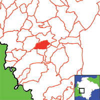
View a map of the boundaries of this town/parish.
You can see maps centred on OS grid reference SX456835 (Lat/Lon: 50.630697, -4.184499), Coryton which are provided by:
- OpenStreetMap
- Google Maps
- StreetMap (Current Ordnance Survey maps)
- Bing (was Multimap)
- Old Maps Online
- National Library of Scotland (Old Ordnance Survey maps)
- Vision of Britain (Click "Historical units & statistics" for administrative areas.)
- English Jurisdictions in 1851 (Unfortunately the LDS have removed the facility to enable us to specify a starting location, you will need to search yourself on their map.)
- Magic (Geographic information) (Click + on map if it doesn't show)
- GeoHack (Links to on-line maps and location specific services.)
- All places within the same township/parish shown on an Openstreetmap map.
- Nearby townships/parishes shown on an Openstreetmap map.
- Nearby places shown on an Openstreetmap map.

