
Hide
Diptford
hide
Hide
hide
- Almanacs◬
- Archives & Libraries◬
- Bibliography◬
- Biography◬
- Business & Commerce Records◬
- Cemeteries◬
- Census
- Chronology◬
- Church History
- Church Records
- Churches
- Civil Registration◬
- Correctional Institutions◬
- Court Records◬
- Description & Travel
- Directories
- Emigration & Immigration◬
- Encyclopaedias & Dictionaries◬
- Folklore◬
- Gazetteers
- Genealogy
- Handwriting◬
- Heraldry◬
- Historical Geography◬
Hide
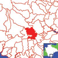
Click on map to view parish boundaries in detail.
Hide
Hide
hide
- History
- Jewish History◬
- Land & Property◬
- Language & Languages◬
- Manors◬
- Maps
- Medical Records◬
- Merchant Marine◬
- Military History◬
- Names, Geographical◬
- Names, Personal◬
- Newspapers◬
- Occupations◬
- Periodicals◬
- Politics & Government◬
- Poor Houses, Poor Law◬
- Population◬
- Probate Records
- Schools◬
- Social Life & Customs◬
- Societies◬
- Taxation◬
- Voting Registers◬
Hide
"DIPTFORD, a small village, on rising ground, in the vale of the river Avon, 5½ miles W.S.W. of Totnes, has in its parish 755 souls. and 4144A. 3R. 15P. of land, including many scattered farm-houses, and lying in several manors. The Rev. W.C. Johnson is lord of the manor of Diptford, formerly held by the Boteler, Courtenay, Fitzcourt, Mules, Sture, and Taylor families. . . . The manor of Bendley and the barton of Stert belong to Mr. Henry Weeks, and were long the property and seat of the Heles. Diptford Court is the seat and property of Thos. Butland, Esq.; and J.S. Cornish, Esq., owns Craberton. The Rev. H. Hare has an estate and neat mansion here, called Courtis Knowle . . . . The Robert, Bartlett, Webber, and other families have estates in the parish. One acre belongs to the Queen. The Church (St. Mary,) is an ancient structure, on an eminence near the river, and has a tower containing six bells, and crowned by a handsome broach spire. The rectory, valued in K.B. at £29. 2s. 1d., and in 1831 at £582, is in the patronage and incumbency of the Rev. W.C. Johnson, who has 2A. 3R. of glebe, and a large and handsome residence. . . .." [From White's Devonshire Directory (1850)]
A parish in Coleridge Hundred, the Archdeaconry of Totnes and the Diocese of Exeter. Avonwick, whose church was built in 1878, is split between the parishes of Diptford, South Brent, North Huish and Ugborough. Regarded as part of the South Hams area.
Hide
Transcript by Kathryn Barnett of the 1841 census, from the Parishes of the South Hams website.
Transcript by Colin Davis of the 1861 census.
Diptford - from J. Stabb. Some Old Devon Churches (London: 1908-16).
George, John T. A short historical account of the church of Saint James, Avonwick. (1990) 45p: ill,ports. [Westcountry Studies Library - p726.5/DIP/GEO]
Scott, Christine. Diptford Past, (2014?). [ISBN 978-0-9567784-1-3] [Devon FHS Tree House Library]
Parish Registers going back to 1653 are held in the Devon Record Office.
The Devon FHS publishes indexes covering (as of June 2004): Baptisms 1813-1839, Marriages 1754-1837, Burials 1813-1837 - for details see their Devon Parish List.
Index to Baptisms (1736-1740), from the Parishes of the South Hams website.
Nothing entered into the IGI (as of Jan 1993).
McNaught, M. J. (transcr.) Devon Registers Vol 8 - Diptford: CMB (BTs) 1596-1601/2, 1611-16, undated entries, 1633-34/5, 1639, CB 1653-1850, M 1653-1837, banns 1837-50, CMB strays 1596-1850; Halwell: C 1584-89/90, 1595-1850, M 1562-88, 1596?-98?, 1602-80, 1684-1850, B 1560-1850, C strays 1584-1850, MB strays 1560-1850; Harberton: CMB (BTs) 1597-1602, 1608-09, 1611-15/16, 1620-21, C 1624-1850, M 1625-27, 1630, 1633, 1635-36/37, 1639-40, 1648-1850, B 1622-1850, CMB strays 1597-1850. [SoG Library DE/R 117]
The Deanery of Totnes: An index of baptisms, marriages and burials . . . with photographs of the churches and extracts from White's Devonshire Directory 1850, CD-ROM, Exeter, Devon FHS (2009). [Ashprington: Bapt (1813-1839), Mar (1754-1837), Bur (1813-1837), Blackawton: Bapt (1813-1839), Mar (1754-1837), Bur (1813-1837), Buckfastleigh: Bapt (1813-1839), Mar (1754-1837), Bur (1813-1837), Cornworthy: Bapt (1813-1839), Mar (1754-1837), Bur (1813-1840), Dartington: Bapt (1813-1839), Mar (1754-1837), Bur (1813-1837), Dartmouth St. Clement: Bapt (1813-1839), Mar (1754-1837), Bur (1813-1837), Dartmouth St. Petrox: Bapt (1813-1839), Mar (1754-1837), Bur (1813-1837), Dartmouth St. Saviour: Bapt (1813-1839), Mar (1754-1837), Bur (1813-1837), Dean Prior: Bapt (1813-1839), Mar (1755-1837), Bur (1790-1837), Diptford: Bapt (1813-1839), Mar (1754-1837), Bur (1813-1837), Dittisham: Bapt (1813-1839), Mar (1754-1837), Bur (1813-1837), Halwell: Bapt (1813-1839), Mar (1755-1837), Bur (1813-1837), Harberton: Bapt (1813-1839), Mar (1754-1837), Bur (1813-1837), Holne: Bapt (1813-1842), Mar (1754-1837), Bur (1813-1837), Rattery: Bapt (1813-1839), Mar (1754-1837), Bur (1800-1837), South Brent: Bapt (1813-1839), Mar (1754-1837), Bur (1813-1837), Stoke Fleming: Bapt (1813-1839), Mar (1754-1837), Bur (1813-1837), Totnes: Bapt (1813-1842), Mar (1754-1837), Bur: (1813-1837)]
Section on Diptford from Samuel Lewis: A Topographical Dictionary of England (1831), provided by Mel Lockie.
Transcription of the entry in White's Devonshire Directory (1850) by Terry Partridge.
Transcription provided by Val Henderson of the entry (description and names) in Morris and Co's Commercial Directory and Gazetteer of Devonshire 1870.
The transcription of the section for this parish from the National Gazetteer (1868), provided by Colin Hinson.
Lysons, Rev Daniel , AM, FRS, FALS, & Samuel Lysons Esq, FRS, FAS. Magna Britannia: Being a concise topographical account of the several counties of Great Britain. Vol VI, Devonshire. London: Thomas Cadell (1822) [Diptford section].
- Ask for a calculation of the distance from Diptford to another place.
The Online Parish Clerk for this parish is Gail Pullybank, who invites queries and lookup requests. (Resources: PRs on Fiche.)
View a map of the boundaries of this town/parish.
You can see maps centred on OS grid reference SX727567 (Lat/Lon: 50.396357, -3.792392), Diptford which are provided by:
- OpenStreetMap
- Google Maps
- StreetMap (Current Ordnance Survey maps)
- Bing (was Multimap)
- Old Maps Online
- National Library of Scotland (Old Ordnance Survey maps)
- Vision of Britain (Click "Historical units & statistics" for administrative areas.)
- English Jurisdictions in 1851 (Unfortunately the LDS have removed the facility to enable us to specify a starting location, you will need to search yourself on their map.)
- Magic (Geographic information) (Click + on map if it doesn't show)
- GeoHack (Links to on-line maps and location specific services.)
- All places within the same township/parish shown on an Openstreetmap map.
- Nearby townships/parishes shown on an Openstreetmap map.
- Nearby places shown on an Openstreetmap map.
Transcript of the will of John Pinhey (1849) by Frances MacKellar.
The South Hams Genealogical Information Resource website offers lookups in their records concerning this parish.