
Hide
Oakford
hide
Hide
hide
- Almanacs◬
- Archives & Libraries◬
- Bibliography◬
- Biography
- Business & Commerce Records◬
- Cemeteries◬
- Census◬
- Chronology◬
- Church History◬
- Church Records
- Churches
- Civil Registration◬
- Correctional Institutions◬
- Court Records◬
- Description & Travel
- Directories◬
- Emigration & Immigration◬
- Encyclopaedias & Dictionaries◬
- Folklore◬
- Gazetteers
- Genealogy
- Handwriting◬
- Heraldry◬
- Historical Geography◬
Hide
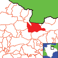
Click on map to view parish boundaries in detail.
Hide
Hide
hide
- History
- Jewish History◬
- Land & Property◬
- Language & Languages◬
- Manors◬
- Maps
- Medical Records◬
- Merchant Marine◬
- Military History◬
- Names, Geographical◬
- Names, Personal
- Newspapers◬
- Occupations◬
- Periodicals◬
- Politics & Government◬
- Poor Houses, Poor Law◬
- Population◬
- Probate Records◬
- Schools◬
- Social Life & Customs◬
- Societies◬
- Taxation
- Voting Registers◬
Hide
"OAKFORD, or Okeford, a village on a bold acclivity, between the Exe and one of its tributary streams, 3 miles W. by S. of Bampton, and 8 miles N.N.W. of Tiverton, has in its parish 641 souls, and 5251 acres of land, rising in lofty hills on the north and west. The manor was anciently held by the Montacutes, and afterwards by the Pollards. Thomas Daniel, Esq., now owns three-fourths of it, and the rest belongs to the Rev. J. Spurway; but J. Browne, Esq., and a few smaller freeholders, have estates in the parish. The Church (St. Peter,) was rebuilt about 12 years ago, and has a tower and eight bells. The organ was given by the late Mrs. Parkin, and a school has been built at her expense. The rectory, valued in K.B. at £24, and in 1831 at £384, is in the patronage and incumbency of the Rev. James Parkin, M.A., who has a good residence and 90A. of glebe. . . . " [From White's Devonshire Directory (1850)]
A parish in Witheridge Hundred, the Archdeaconry of Barnstaple, and the Diocese of Exeter.
Hide
Palfrey, Vi. The Search for George Palfrey, Devon Family Historian, vol. 127, (2008) pp.5-6.
| St Peter, Oakford, Church of England |
Parish Registers going back to 1568 are held in the Devon Record Office.
Transcripts of the Parish Registers going back to 1568 are held in a special collection in the Westcountry Studies Library.
The Devon FHS publishes indexes covering (as of June 2004): Baptisms 1813-1839, Marriages 1754-1837, Burials 1813-1840 - for details see their Devon Parish List.
Other churches and chapels (with pre-1840 records):
- Wesleyan Chapel: Registers for c1812-37 - see Tiverton (PRO RG 4/342)
Entered into the IGI (as of Jan 1993): Parish Church Christenings 1568-1812 and Marriages 1568-1812.
The Deanery of South Molton: An index of baptisms, marriages and burials in the parishes of Bishop's Nympton, Cheldon, Creacombe, Cruwys Morchard, East Anstey, East Woolfardisworthy, East Worlington, George Nympton, King's Nympton, Knowstone, Mariansleigh, Meshaw, Molland, North Molton, Oakford, Puddington, Rackenford, Romansleigh, Rose Ash, Satterleigh, South Molton, Stoodleigh, Templeton, Thelbridge, Twitchen, Warkleigh, Washford Pyne, West Anstey, West Worlington and Witheridge. With photographs of the churches and extracts from White's Directory (1850) and Kelly's Directory of Devonshire (1902). CD-ROM 062, Exeter, Devon FHS (2015). [Bishop's Nympton Bapt: 1813-1839, Mar: 1754-1837, Bur: 1813-1837; Cheldon Bapt: 1813-1843, Mar: 1755-1835, Bur: 1813-1841; Creacombe Bapt: 1814-1902, Mar: 1759-1835, Bur: 1813-1850; Cruwys Morchard Bapt: 1813-1840, Mar: 1754-1837, Bur: 1813-1837; East Anstey Bapt: 1813-1840, Mar: 1754-1836, Bur: 1688-1839; East Woolfardisworthy Bapt: 1813-1840, Mar: 1754-1840, Bur: 1813-1837; East Worlington Bapt: 1813-1840, Mar: 1754-1837, Bur: 1813-1837; George Nympton Bapt: 1813-1840, Mar: 1755-1837, Bur: 1790-1837; King's Nympton Bapt: 1813-1840, Mar: 1754-1837, Bur: 1813-1837; Knowstone Bapt: 1813-1840, Mar: 1740-1836, Bur: 1813-1837; Mariansleigh Bapt: 1813-1839, Mar: 1757-1837, Bur: 1813-1838; Meshaw Bapt: 1813-1839, Mar: 1756-1836, Bur: 1813-1838; Molland Bapt: 1813-1840, Mar: 1754-1837, Bur: 1813-1838; North Molton Bapt: 1813-1839, Mar: 1754-1837, Bur: 1813-1837; Oakford Bapt: 1813-1839, Mar: 1754-1837, Bur: 1813-1840; Puddington Bapt: 1813-1839, Mar: 1759-1836, Bur: 1740-1837; Rackenford Bapt: 1813-1840, Mar: 1754-1837, Bur: 1800-1837; Romansleigh Bapt: 1813-1839, Mar: 1754-1836, Bur: 1730-1837; Rose Ash Bapt: 1813-1839, Mar: 1754-1837, Bur: 1813-1850; Satterleigh Bapt: 1813-1839, Mar: 1755-1836, Bur: 1813-1837; South Molton Bapt: 1813-1840, Mar: 1754-1837, Bur: 1813-1837; Stoodleigh Bapt: 1813-1840, Mar: 1754-1837, Bur: 1813-1837; Templeton Bapt: 1813-1840, Mar: 1754-1837, Bur: 1813-1837; Thelbridge Bapt: 1813-1839, Mar: 1754-1837, Bur: 1813-1853; Twitchen Bapt: 1813-1839, Mar: 1755-1836, Bur: 1813-1837; Warkleigh Bapt: 1813-1839, Mar: 1754-1837, Bur: 1813-1851; Washford Pyne Bapt: 1813-1840, Mar: 1756-1836, Bur: 1813-1840; West Anstey Bapt: 1813-1840, Mar: 1754-1836, Bur: 1745-1838; West Worlington Bapt: 1813-1840, Mar: 1754-1846, Bur: 1813-1851; Witheridge Bapt: 1813-1839, Mar: 1754-1837, Bur: 1813-1835]
Oakford village website.
Section on Oakford from Samuel Lewis: A Topographical Dictionary of England (1831), provided by Mel Lockie.
The transcription of the section for this parish from the National Gazetteer (1868), provided by Colin Hinson.
- Ask for a calculation of the distance from Oakford to another place.
Loosemore of Devon - by W.R. Loosemoore.
Bentley, E.W. Oakford: the history of a Devon parish. Oakford: E.W. Bentley (1982) 239p: map. [ISBN 0950794201]
View a map of the boundaries of this town/parish.
You can see maps centred on OS grid reference SS910212 (Lat/Lon: 50.979858, -3.554074), Oakford which are provided by:
- OpenStreetMap
- Google Maps
- StreetMap (Current Ordnance Survey maps)
- Bing (was Multimap)
- Old Maps Online
- National Library of Scotland (Old Ordnance Survey maps)
- Vision of Britain (Click "Historical units & statistics" for administrative areas.)
- English Jurisdictions in 1851 (Unfortunately the LDS have removed the facility to enable us to specify a starting location, you will need to search yourself on their map.)
- Magic (Geographic information) (Click + on map if it doesn't show)
- GeoHack (Links to on-line maps and location specific services.)
- All places within the same township/parish shown on an Openstreetmap map.
- Nearby townships/parishes shown on an Openstreetmap map.
- Nearby places shown on an Openstreetmap map.
Oakford contributors to a 1678 brief for the rebuilding of St Paul's Cathedral.