
Hide
Wrightington
hide
Hide
hide
Hide
hide
Hide
Hide
WRIGHTINGTON, a township-chapelry in Eccleston parish, Lancashire; at Appleby-Bridge r. station, and 4 miles NW of Wigan. It has a post-office under Wigan. Acres, 3,876. Real property, £7,423; of which £41 are in quarries. Pop., 1,618. Houses, 305. W. Hall is the seat of T. Dicconson, Esq.; and Harrock Hall, of Mrs. Bolton. The living is a p. curacy in the diocese of Manchester. Value, £128. Patron, the Rector of Eccleston. The church was built in 1857. There are Independent, Primitive Methodist, and Roman Catholic chapels.
John Marius Wilson, Imperial Gazetteer of England and Wales (1870-72)
Hide
Local studies information is held at Wigan library.
| All Saints, Appley Bridge, Church of England |
| St James the Great, Wrightington, Church of England |
| Tunley Chapel Presbyterian, Wrightington |
| St Joseph, Wrightington, Roman Catholic |
Details about the census records, and indexes for Wrightington.
| All Saints, Appley Bridge, Church of England |
| St James the Great, Wrightington, Church of England |
| Appley Lane, Wrightington, Wesleyan Methodist |
| Carr House Lane, Wrightington, Primitive Methodist |
| Tunley Chapel Presbyterian, Wrightington |
| St Joseph, Wrightington, Roman Catholic |
The Register Office covering the Wrightington area is West Lancashire.
The National Gazetteer of Great Britain and Ireland - 1868
"WRIGHTINGTON, a township and ecclesiastical district in the parish of Eccleston, hundred of Leyland, county Lancaster, 5 miles N.W. of Wigan, and half a mile from Appley Bridge railway station. It is situated near the Liverpool canal and the river Douglas. The inhabitants are chiefly employed in cotton spinning and in the collieries. The principal residences are Wrightlington Hall and Harrock Hall, the former an old seat of the Scarisbrick family. The living is a perpetual curacy in the diocese of Manchester, value £110, in the patronage of the Rector of Eccleston. The Roman Catholics, Independents, and Primitive Methodists have chapels."
- Ask for a calculation of the distance from Wrightington to another place.
In 1835 Wrightington was a township in the parish of Eccleston.
View maps of Wrightington and places within its boundaries.
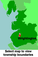
View a map of the boundaries of this town/parish.
You can see maps centred on OS grid reference SD514119 (Lat/Lon: 53.601223, -2.735397), Wrightington which are provided by:
- OpenStreetMap
- Google Maps
- StreetMap (Current Ordnance Survey maps)
- Bing (was Multimap)
- Old Maps Online
- National Library of Scotland (Old Ordnance Survey maps)
- Vision of Britain (Click "Historical units & statistics" for administrative areas.)
- English Jurisdictions in 1851 (Unfortunately the LDS have removed the facility to enable us to specify a starting location, you will need to search yourself on their map.)
- Magic (Geographic information) (Click + on map if it doesn't show)
- GeoHack (Links to on-line maps and location specific services.)
- All places within the same township/parish shown on an Openstreetmap map.
- Nearby townships/parishes shown on an Openstreetmap map.
- Nearby places shown on an Openstreetmap map.
For probate purposes prior to 1858, Wrightington was in the Archdeaconry of Chester, in the Diocese of Chester. The original Lancashire wills for the Archdeaconry of Chester are held at the Lancashire Record Office.
You can also see Family History Societies covering the nearby area, plotted on a map. This facility is being developed, and is awaiting societies to enter information about the places they cover.