
Hide
Owston
hide
Hide
hide
Hide
hide
Hide
Hide
Owston, par. and township, Lincolnshire - par., 5,350 ac., pop. 2,058; township, pop. 1,322; contains OWSTON FERRY.
From: John BARTHOLOMEW's "Gazetteer of the British Isles (1887)"
Hide
The Gainsborough Library is an excellent resource with both a Local History section and a Family History section.
- A cemetery of 1.5 acres was formed in 1881 and land purchased in 1883. It was under the control of the parish council.
| Epworth Road, Owston Ferry, Cemetery |
- Owston was the heart of the Owston sub-district in the Gainsborough Registration District.
- Check our Census Resource page for county-wide resources.
- The table below gives census piece numbers, where known:
| Census Year | Piece No. |
|---|---|
| 1841 | H.O. 107 / 641 |
| 1861 | R.G. 9 / 2405 |
| 1871 | R.G. 10 / 3439 |
| 1891 | R.G. 12 / 2631 |
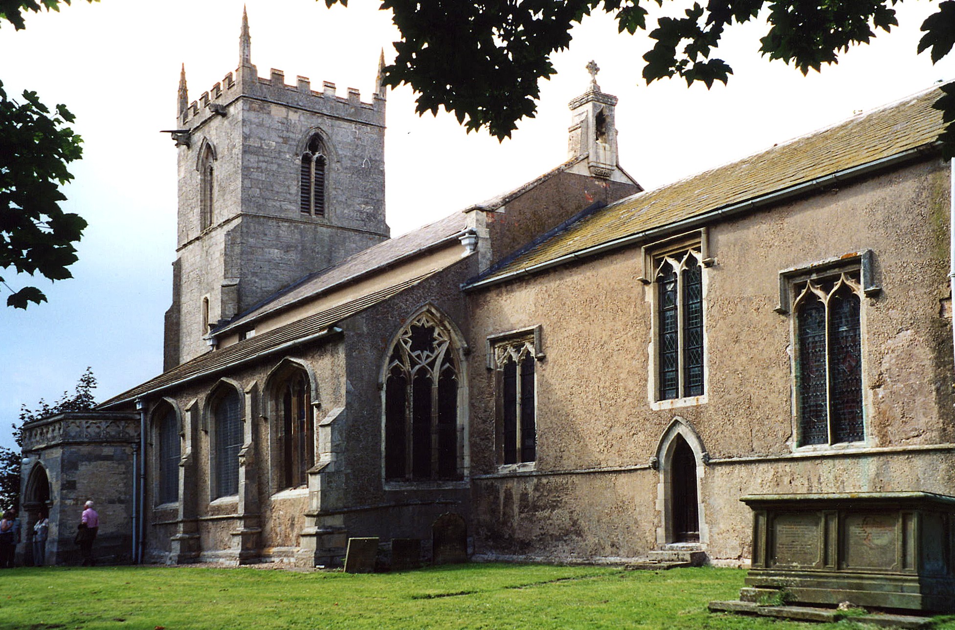
- The Anglican parish church is dedicated to Saint Martin.
- The church building partly dates from the end of the 12th century.
- The church was rebuilt in 1844.
- The church seats 600.
- There is a photograph of St. Martin's Church on the Wendy PARKINSON Church Photos web site.
- Richard CROFT has a photograph of St. Martin's Church on Geo-graph, taken in 2005.
- Here is a photo of St. Martin's Church taken by Ron COLE (who retains the copyright):
- The Anglican parish register dates from 1603 as a collection of loose pages. The registers are continuous from 1709 on.
- The churchwarden account books have survived from 1660 to 1684.
- Check the Isle of Axholme Deanery to see which LFHS marriage indexes exist.
- The Wesleyan Methodist Chapel was built in 1837. For information and assistance in researching this chapel, see our non-conformist religions page.
- Check our Church Records page for county-wide resources.
- The parish was in the Owston sub-district in the Gainsborough Registration District.
- Check our Civil Registration page for sources and background on Civil Registration which began in July, 1837.
Owston is a parish, a township and a large village on the west bank of the Trent River about 8 miles north of Gainsborough. The parish covers some 5,350 acres and includes the township of West Butterwick-with-Kelfied.
If you are planning a visit:
- Visit our touring page for more sources.
- Ask for a calculation of the distance from Owston to another place.
- The MOWBRAY family had a fortified tower here, called Kinafare Castle, which commanded the passage of the River Trent. No traces remain of this tower.
- See the history of Owston provided by the Isle of Axholme FHS.
- Owston Ferry Smithy Heritage Centre & Village Museum has photos and old farm and boating tools, a working smithy, old relics that locals have found in their lofts. They've got copies of the Indexes for the Parish for visitors to consult. [Sheila Wilson]
- Gas Works were built in the village in 1864.
- See our Maps page for additional resources.
You can see maps centred on OS grid reference SE809003 (Lat/Lon: 53.493196, -0.78206), Owston which are provided by:
- OpenStreetMap
- Google Maps
- StreetMap (Current Ordnance Survey maps)
- Bing (was Multimap)
- Old Maps Online
- National Library of Scotland (Old Ordnance Survey maps)
- Vision of Britain (Click "Historical units & statistics" for administrative areas.)
- English Jurisdictions in 1851 (Unfortunately the LDS have removed the facility to enable us to specify a starting location, you will need to search yourself on their map.)
- Magic (Geographic information) (Click + on map if it doesn't show)
- GeoHack (Links to on-line maps and location specific services.)
- All places within the same township/parish shown on an Openstreetmap map.
- Nearby townships/parishes shown on an Openstreetmap map.
- Nearby places shown on an Openstreetmap map.
- Alan MURRAY-RUST has a photograph of the War Memorial at Owston Ferry on Geo-graph, taken in 2011.
For a photograph of the Owston Ferry War Memorial and the list of names on it, see the Roll of Honour site.
- This place was anciently called Kinaird Ferry.
- The name Owston is from the Old Scandinavian austr+tun, meaning "east farmstead." In the 1086 Domesday Book it is rendered as Austhun.
[A. D. MILLS, "A Dictionary of English Place-Names," Oxford University Press, 1991]
- The parish was in the ancient Manley Wapentake in the West Lindsey district in the parts of Lindsey.
- In 1841, West Butterwick parish was formed from the northeast portion of Owston parish.
- In the 1972 government redistricting, Owston became part of the Boothferry District, which is now in the County of Humberside (formerly Lindsey, Lincolnshire).
- District governance is currently provided by the North Lincolnshire Council.
- Bastardy cases were heard in the Epworth petty session courts.
- The Common Land was enclosed here in 1803.
- As a result of the 1843 Poor Law Amendment Act, the parish became part of the Gainsborough Poor Law Union.
- Miss Frances SAUNDERS had almshouses built in 1860 for six poor women.
- Alan MURRAY-RUST has a photograph of the almshouses on Geo-graph, taken in 2011.
Year Inhabitants 1801 917 1831 1,409 1851 2,613 1861 2,520 1871 1,527 1881 1,322 1891 1,294 1901 1,204 1911 1,159
- The village of Owston had a Public Elementary School that was built for 230 children.
- The hamlet of Gunthorpe had a Public Elementary School that was built in 1910 for 40 children.
- See our Schools page for more information on researching school records.
The local genealogical society is the Isle of Axholme FHS.