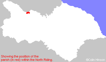
Hide
Wycliffe
hide
Hide
hide
Hide
Hide
The Ancient Parish of WYCLIFFE
[Transcribed information mainly from the early 1820s]
"WYCLIFFE, "the cliffe by the water" a parish in the wapentake of Gilling West, and liberty of Richmondshire; 5 miles SE. of Barnard Castle. The church is an ancient edifice (see Churches for photograph), re-built in the reign of Edward III. The living is a rectory, in the patronage of the lord of the manor, but the patrons being Catholics it has been repeatedly presented by the University of Cambridge; the incumbent is the Rev. John Headlam, who resides in the rectory house at Thorpe. Here it is said that John Wycliffe, the reformer, was born; and Dr. Thomas Zouch, the late rector of this parish, has presented an original picture of this Morning Star of the Reformation, who he says, was a native of this parish, to the rectors of Wycliffe, as an heirloom. Leyland says, that John Wickliffe hoereticus, was born at Spreswell, near Richmond; and in that immediate neighbourhood is Willecliff pronounced exactly like the reformer's name, which Wycliffe is not. At all events the dispute is only about a few miles, and the claim of Yorkshire and even of Richmondshire to the birth of the Father of the Reformation is undisputed (Dr Whitaker's Richmondshire). Pop. 152.On the 11th October, 1790, died at Wycliffe hall, Marmaduke Tunstall, Esq. F.r. and A.S.S. In the privacy of an elegant retirement, he was a most munificent patron of learning, being ever ready to encourage and reward merit. His knowledge was uncommonly extensive. He corresponded with most of the learned men of his country, and with many foreigners of distinguished character in the republic of letters. Great as his literary abilities were, he possessed more valuable accomplishments; a sweet affability of disposition, an engaging urbanity of manners, an enlarged liberality of thought; he was all mildness and benevolence. His deeds of charity were many; he was literally the poor man's friend."
"GIRLINGTON, a farm house in the township of Thorpe, and parish of Wycliffe; 1 mile ESE. of Wycliffe, 6 miles from Barnardcastle, (Dur.) 9 from Richmond."
"THORPE, (with Wycliffe) in the parish of Wycliffe, wapentake of Gilling West; 5 miles SE. of Barnard Castle; a small township, situated on the banks of the river Tees. There is here a private chapel of the Catholic persuasion. Pop. 152."
[Description(s) edited mainly from various 19th century sources by Colin Hinson. ©2010]
Hide
- Here are photographs of the Churches in the parish:
- St Mary's Church, Wycliffe.
- St Mary's Church, Wycliffe.
- St. Mary's Roman Catholic Church, Wycliffe. (The Church's website is here.)
- Transcript of the entry for Wycliffe in the "Collections relative to Churches and Chapels".
- The whereabouts and dates of the Registers etc. for the Parish of Wycliffe.
- Transcript of the entry of "professions and trades" in the Baines's Directory of 1823, of the North Riding.
- Transcript of the entry of "professions and trades" in the Bulmers Directory of 1890. of the North Riding.
- There is further information about this parish from the National Gazetteer 1868, Yorkshire extracts.
- There is further information about this parish from the Lewis's Topographical Dictionary of England 1835, Yorkshire extracts.
- There is further information about this parish from the Bulmer's 1890 History and Directory of the North Riding.
- Ask for a calculation of the distance from Wycliffe to another place.

- For a detailed map of this parish see this parish boundaries map.
- For a more detailed map of the parishes in the riding please see the Yorkshire parish maps page.
- For a more detailed map of the county please see the Yorkshire map page.
- Here is a map showing the wapentakes for the county.
You can see maps centred on OS grid reference NZ115142 (Lat/Lon: 54.522962, -1.823843), Wycliffe which are provided by:
- OpenStreetMap
- Google Maps
- StreetMap (Current Ordnance Survey maps)
- Bing (was Multimap)
- Old Maps Online
- National Library of Scotland (Old Ordnance Survey maps)
- Vision of Britain (Click "Historical units & statistics" for administrative areas.)
- English Jurisdictions in 1851 (Unfortunately the LDS have removed the facility to enable us to specify a starting location, you will need to search yourself on their map.)
- Magic (Geographic information) (Click + on map if it doesn't show)
- GeoHack (Links to on-line maps and location specific services.)
- All places within the same township/parish shown on an Openstreetmap map.
- Nearby townships/parishes shown on an Openstreetmap map.
- Nearby places shown on an Openstreetmap map.
- The following places are within the boundaries of this (ancient) parish, but I have no further information on them other than the Ordnance Survey Landranger Grid reference shown:
- (NZ128136) Girlington Hall
- This parish is covered by the following Society:

