
Hide
Ballymachugh Down Survey Map
hide
Hide
The Down Survey was done by Sir William Petty in the middle of the 17th century. The map below represents a tracing said to be made from one of his some 2,000 parish maps. The tracings appear to be held in PRONI but the drawing below mas made from a microfilm photostat made at the County Cavan Library.
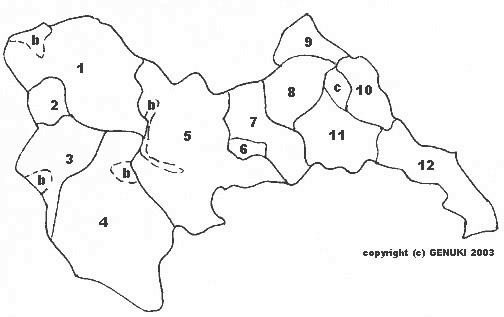
| Map Reference | Down Survey Tracing | Bibliothèque Nationale (Barony Maps) | Hiberniae Delineatio |
| b. | bog | ||
| 1. | Agheekillmore | Agheekillmore | Aghekillmore |
| 2. | The Gallon of Tawlaght | Tawloght Gallon | Towlot Gallon |
| 3. | Tawlagh Pole | Tawlaght Pole | Tawlatpoll |
| 4. | Moydriston | Moydriston | Moydriston |
| 5. | Aghecreevy | Aghecreevy | Ahacrevvy |
| 6. | Ballimachugh | ||
| 7. | Lawagh | Lawagh | Lawagh |
| 8. | Corcloghan | Corcloghan | |
| 9. | Lisduffe | Lisdufe | Lisduffe |
| c. | A Comon belonging to adjacent Towns | ||
| 10. | Thureen | Thureene | Thureen |
| 11. | Corfarnego | Corfarnego | Corsarneg |
| 12. | Crowooar | Crowaar | Crova |