
Hide
Old Deer
hide
Hide
hide
Hide
Hide
Hide
"Deer, Old, vil., Aberdeenshire, and par., partly also in detached portion of Banffshire -- par., 27,363 ac., pop. 5104; vil., 1 mile SW. of Mintlaw sta. and 9½ miles W. of Peterhead; P.O.; has remains of St Mary's Abbey of Deer, a Cistercian monastery founded 1218-19; all traces of the previous Columban monastery, founded by Columba and his nephew Drostan (close of the 6th century), have disappeared; according to the Book of Deer, it retained its Columban and Celtic character down to the reign of David I. (1123-1153)."
Bartholomew's Gazetteer of the British Isles, 1887
Hide
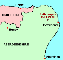
The parish of Old Deer is nowadays reckoned as belonging to Aberdeenshire, and the main article about it will therefore be found among the GENUKI Aberdeenshire pages. However, before the major re-alignment of parish and county boundaries which came into effect on 1st May 1891, the parish belonged in part to Banffshire. The remaining articles on this page give details.
Hide
- Ask for a calculation of the distance from Old Deer to another place.
According to the Minister, writing for the "New Statistical Account" in 1840: "... the [Banffshire] portion is generally supposed to be a detached part of a great barony, the body of which constitutes the parish of St Fergus, that belonged to a family of the name of Cheyne, once hereditary Sheriffs of the County of Banff ..."
This anomaly is probably of academic interest only, as the OPRs, the civil records of Births, Deaths and Marriages, and the Census for the whole parish of Old Deer are nowadays all catalogued under Aberdeenshire. However, it is possible that older land transactions in this area may be recorded under Banffshire.
You can see maps centred on OS grid reference NJ976478 (Lat/Lon: 57.520179, -2.041333), Old Deer which are provided by:
- OpenStreetMap
- Google Maps
- StreetMap (Current Ordnance Survey maps)
- Bing (was Multimap)
- Old Maps Online
- National Library of Scotland (Old Ordnance Survey maps)
- Vision of Britain (Click "Historical units & statistics" for administrative areas.)
- Magic (Geographic information) (Click + on map if it doesn't show)
- GeoHack (Links to on-line maps and location specific services.)
- All places within the same township/parish shown on an Openstreetmap map.
- Nearby townships/parishes shown on an Openstreetmap map.
- Nearby places shown on an Openstreetmap map.