
Hide
Gileston
hide
Hide
hide
Hide
hide
Hide
Hide
"Gileston, in the Cwmwd of Maenor Glynn Ogwr, Cantref of Cron Nedd (now called the Hundred of Ogmore), County of GLAMORGAN, South Wales: a discharged Rectory, valued in the King's Books at £5..13..6 1/2: Patron, The Rev. John Edwardes: Church dedicated to St. Giles. The Resident Population of this Parish, in 1801, was 60. The Money raised by the Parish Rates, in 1803, was £7..17..2 1/4. It is 6 m. S. b. E. from Cowbridge. This Parish contains 340 acres of cultivated Land: and is situate upon St. George's Channel. According to the Diocesan Report, in 1809, the yearly value of this Benefice, arising from Tythes, Glebe, and Augmentation, was £63..15..2." From: A Topographical Dictionary of The Dominion of Wales by Nicholas Carlisle, London, 1811.
Hide
Here is a substantial reading list of books which relate to Glamorgan, either county or parish.
The Glamorgan Family History Society have produced a set of microfiche containing Monumental Inscriptions for the following burial grounds :-
- Parish Church of St. Giles
| St Giles, Gileston |
Glamorgan Chapels Database - No nonconformist chapel references found for this parish
A view of a Manor house and a church at Gileston with a woman and two children on the front lawn. - on the People's Collection Wales site
For full and up-to-date details of their holdings see the sites of Glamorgan Record Office and/or West Glamorgan Archives
See Bap/Mar/Bur data on FreeReg
The parish church is dedicated to St. Giles, and in the Benefice of Eglwys Brewis with St Athan with Gileston. Details of the present incumbent of this benefice can be found at the Church in Wales website. The church can be located at grid reference ST017671.
A transcription of the registers is available from the Glamorgan Family History Society for the years: Baptisms, 1701-1940, Marriages, 1701-1836, Burials, 1702-1946. Visit their website for information on how to purchase these fiche.
| Anglican Parish Registers Held at the Glamorgan Record Office, Cardiff | ||||
| Baptisms | Marriages | Burials | Banns | Bishops Transcripts |
| 1701-1988 | 1813-1971 | 1813-1940 | - | 1721-1722, 1724-1732, 1734-1738, 1740-1742, 1744-1749, 1751-1755, 1757-1758, 1760-1768, 1771-1818, 1820-1837 |
Details of extant records on Archives Network Wales for the following;
- Gileston Ecclesiastical Parish records "........ including register of baptisms, marriage and burial, 1701-1812; register of services, 1929-1951; facsimile registers of baptism, 1813-1991; marriage, 1820-1970; burials, 1814-1992"
The following Religious Institutions are covered in the Mormon International Genealogical Index (IGI) :-
- Gileston, St. Giles - Christenings (BT's), 1814-1875
Gileston - on Wikipedia
Conservation areas within the Vale of Glamorgan. See Gileston - "Conservation areas are areas of special architectural or historic interest, the character or appearance of which it is desirable to preserve or enhance"
Various landscapes - on the People's Collection Wales site
Transcript of complete name listing for St. Athan, with the parishes and villages of Eglwys Brewis, Gileston, Llancarfan and Penmark, from Slaters Directory for 1880.
The transcription of the section for Gileston from The National Gazetteer (1868) provided by Colin Hinson.
Description of parish from A Topographical Dictionary of Wales (1833) by Samuel Lewis.
- Ask for a calculation of the distance from Gileston to another place.
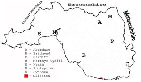
This diagram shows the position of this parish within the county of Glamorgan - click on this to see a full size diagram of the county
|
Plan of the parish of Gileston, Glamorgan - on the People's Collection Wales site
Parish map (Kain/Oliver)
You can see maps centred on OS grid reference ST014668 (Lat/Lon: 51.391761, -3.418507), Gileston which are provided by:
- OpenStreetMap
- Google Maps
- StreetMap (Current Ordnance Survey maps)
- OpenStreetMap Cymru (Welsh counties only)
- Bing (was Multimap)
- Old Maps Online
- National Library of Scotland (Old Ordnance Survey maps)
- Vision of Britain (Click "Historical units & statistics" for administrative areas.)
- Magic (Geographic information) (Click + on map if it doesn't show)
- GeoHack (Links to on-line maps and location specific services.)
- All places within the same township/parish shown on an Openstreetmap map.
- Nearby townships/parishes shown on an Openstreetmap map.
- Nearby places shown on an Openstreetmap map.
Places, villages, farms etc within Gileston parish as shown on the online parish map from the CD of Historic Parishes of England and Wales: an Electronic Map of Boundaries before 1850 with a Gazetteer and Metadata [computer file]. (Kain, R.J.P., Oliver, R.R.). (Extracted by Glenys Travis)
- Gileston [170] - Gileston, Limpert Bay, Limpert, Manor Ho, Seaview, The Walls.
The Population of Gileston was as follows, and a more detailed breakdown is available.
| 1841 - 43 | 1851 - 65 | 1861 - 70 | 1871 - 49 | 1881 - 52 | 1891 - 62 |
Details of extant records on Archives Network Wales for the following;
- Gileston Civil Parish records " ........comprising copies of the tithe plan and apportionment, c1840"