
Hide
Bickleigh (Near Plymouth)
hide
Hide
hide
- Almanacs◬
- Archives & Libraries◬
- Bibliography◬
- Biography
- Business & Commerce Records◬
- Cemeteries
- Census
- Chronology◬
- Church History
- Church Records
- Churches
- Civil Registration◬
- Correctional Institutions◬
- Court Records◬
- Description & Travel
- Directories
- Emigration & Immigration◬
- Encyclopaedias & Dictionaries◬
- Folklore◬
- Gazetteers
- Genealogy
- Handwriting◬
- Heraldry◬
- Historical Geography◬
Hide
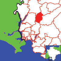
Click on map to view parish boundaries in detail.
Hide
Hide
hide
- History
- Jewish History◬
- Land & Property◬
- Language & Languages◬
- Manors◬
- Maps
- Medical Records◬
- Merchant Marine◬
- Military History◬
- Military Records
- Names, Geographical◬
- Names, Personal◬
- Newspapers◬
- Occupations◬
- Periodicals◬
- Politics & Government◬
- Poor Houses, Poor Law◬
- Population◬
- Probate Records◬
- Schools◬
- Social Life & Customs◬
- Societies◬
- Taxation◬
- Voting Registers◬
Hide
"BICKLEIGH is a small village on the western side of the river Plym, in the picturesque vale to which it gives name, six miles N. by E. of Plymouth. Its parish contains 469 souls, and 2980 acres of land, including the village of Jump, and many scattered houses. Bickleigh Vale is much resorted to by anglers and the lovers of woodland scenery, who find excellent entertainment at Maristow Inn. . . . The manor was long held by Buckland Abbey, and afterwards by the Slannings, Modyfords, and Heywoods, the latter of whom sold it to S.M.M. Lopes in 1798. . . . The Church was rebuilt by Sir R. Lopes, in 1839, except the tower, which has six bells. The interior is neatly fitted up, and the east window is enriched with stained glass. . . . " [From White's Devonshire Directory (1850)]
A parish in Roborough Hundred, the Archdeaconry of Totnes, and the Diocese of Exeter. Includes the hamlet of Roborough. Regarded as part of the South Hams area.
Hide
Morris, Anna Bonathan. A Letter from India, 1851, Devon Family Historian, vol. 142, (2012) pp.6-7. [By William Bonathan aka Bailey (b. Bickleigh 1821)]
Helmore, Peter M.R. Thomas Matthews from Bickleigh, Devon Family Historian, vol. 96, (Nov 2000) pp. 3-8. [Thomas Matthews (1868-1938) served in Burma, India, and South Africa with the Devonshire Regiment]
Brown, Mike. Bickleigh (Pre-1900 Survey). In Dartmoor Region Monumental Inscriptions Indexes, Vol. 2. Dartmoor Press, PO Box 132, Plymouth PL4 7YL.
Transcription of the 1861 census, by Wayne Shepheard.
St Mary the Virgin, Bickleigh, by Graham Naylor.
Parish Registers going back to 1694 are held in the Devon Record Office.
The Devon FHS publishes indexes covering (as of June 2004): Baptisms 1813-1839, Marriages 1754-1837, Burials 1811-1837 - for details see their Devon Parish List.
Other churches and chapels (with pre-1840 records):
- Wesleyan Chapel: Registers for c.1813-37 - see Ebenezer Chapel, Plymouth (PRO RG 4/1325)
Nothing entered into the IGI (as of Jan 1993).
The Deanery of Tamerton, CD, Devon Family History Society, Exeter (2003). [Contains indexes: Bere Ferrers - Baptisms 1813-1840, Marriages 1754-1837, Burials 1813-1837; Bickleigh - Baptisms 1813-1839, Marriages 1754-1837, Burials 1811-1837; Buckland Monachorum - Baptisms, 1813-1839 Marriages 1754-1837, Burials 1813-1837; Egg Buckland - Baptisms 1813-1839 Marriages, 1754-1837, Burials 1813-1837; Mary Tavy - Baptisms 1813-1840 Marriages, 1754-1837, Burials 1813-1837; Meavy - Baptisms 1813-1839 Marriages, 1754-1837, Burials 1813-1838; Peter Tavy - Baptisms 1813-1839, Marriages, 1754-1837, Burials 1790-1837; Sampford Spiney - Baptisms 1813-1839 Marriages, 1754-1837, Burials 1770-1837; Sheepstor - Baptisms 1813-1839 Marriages, 1754-1837, Burials 1813-1856; Tamerton Foliot - Baptisms 1813-1840 Marriages, 1754-1837, Burials 1813-1837; Walkhampton - Baptisms 1813-1840 Marriages, 1754-1837, Burials 1813-1837; Whitchurch - Baptisms 1813-1839 Marriages, 1754-1838, Burials 1813-1837]
Bickleigh Parish Council website - general information.
Section on Bickleigh from Samuel Lewis: A Topographical Dictionary of England (1831), provided by Mel Lockie.
Barber, Chips. Bickleigh - A Visitor's Guide. Pinhoe, Exeter: Obelisk Publications. [ISBN 189907371x].
Transcription of the entry in White's Devonshire Directory (1850) by Terry Partridge.
Transcription provided by Val Henderson of the entry (description and names) in Morris and Co's Commercial Directory and Gazetteer of Devonshire 1870.
The transcription of the section for this parish from the National Gazetteer (1868), provided by Colin Hinson.
- Ask for a calculation of the distance from Bickleigh (Near Plymouth) to another place.
The Online Parish Clerk scheme's representative for this parish is Alick Lavers, who invites queries and lookup requests. (Resources: 1841-1891 censuses; baptism, marriage & burials on fiche.)
Jones, Winslow. The Slannings of Leye, Bickleigh, and Maristow. Trans. Devon. Assoc. vol. 19 (1887), pp. 451-66. [Includes pedigrees, 16-18th c.] [Index]
Jones, Winslow. The Slannings of Leye, Bickleigh, and Maristow. Trans. Devon. Assoc. vol. 20 (1888), pp. 304-305. [Index]
Worthy, C. Devonshire Parishes: or the antiquities, heraldry and family history of twenty-eight parishes in the archdeaconry of Totnes (2 vols), Exeter, W. Pollard (1887). [Chap. I: Bickleigh - Families of SLANNING and LOPES] [Index]
Dartmoor Press Online Magazine's page for this parish (archived copy), with articles, transcriptions, publication details, etc. - highly recommended.
Bellamy, J.C. Bickleigh and its Church. (Reprint from the Plymouth Herald, 15 May 1852) 1852 [Westcountry Studies Library]
Gray, Vera. Bickleigh Mill on the River Meavy, Trans. Devon. Assoc., vol. 120, (1988) pp.81-86: ill, map.
Gray, Vera. A leat on Roborough Down and an early seventeenth century tinners' dispute, Trans. Devon. Assoc., vol. 122, (1990) pp.71-82: maps.
Worthy, Charles. Devonshire Parishes. Exeter: William Pollard (1887) - Vol. 1, pp. 1- 23.
Maps of Roborough Down in George III's Collection of Military Maps.
View a map of the boundaries of this town/parish.
You can see maps centred on OS grid reference SX520623 (Lat/Lon: 50.441834, -4.085649), Bickleigh (Near Plymouth) which are provided by:
- OpenStreetMap
- Google Maps
- StreetMap (Current Ordnance Survey maps)
- Bing (was Multimap)
- Old Maps Online
- National Library of Scotland (Old Ordnance Survey maps)
- Vision of Britain (Click "Historical units & statistics" for administrative areas.)
- English Jurisdictions in 1851 (Unfortunately the LDS have removed the facility to enable us to specify a starting location, you will need to search yourself on their map.)
- Magic (Geographic information) (Click + on map if it doesn't show)
- GeoHack (Links to on-line maps and location specific services.)
- All places within the same township/parish shown on an Openstreetmap map.
- Nearby townships/parishes shown on an Openstreetmap map.
- Nearby places shown on an Openstreetmap map.