
Hide
Bretherton
hide
Hide
hide
Hide
hide
Hide
Hide
BRETHERTON, a township-chapelry in Croston parish, Lancashire; on the Douglas river, 1 mile E of Croston r. station, and 9 SSW of Preston. It has a post office under Chorley. Acres, 2,405. Real property, £4,485. Pop., 775. Houses, 149. The property is not much divided. The living is a rectory in the diocese of Manchester. Value, £150.* Patron, the Rector of Croston. The church is a recent structure, in the early English style. There are an Independent chapel, a Wesleyan chapel, and an endowed school; the last founded in 1654, and having £112 a year.
John Marius Wilson, Imperial Gazetteer of England and Wales (1870-72)
Hide
Local studies information is held at Chorley library.
| Ebenezer Independent, Bretherton |
Details about the census records, and indexes for Bretherton.
| Ebenezer Independent, Bretherton |
The Register Office covering the Bretherton area is Chorley.
The National Gazetteer of Great Britain and Ireland - 1868
"BRETHERTON, formerly a township in the parish of Croston, but now a parish of itself, in the hundred of Leyland, in the county palatine of Lancaster, 7 miles to the W. of Chorley. It is seated on the banks of the river Douglas, near the Lancashire and Yorkshire railway, which has a station at Croston. The living is a perpetual curacy in the diocese of Manchester, of the value of £150, in the patronage of the Rector of Croston. The church is a new building in the early English style, dedicated to St. John the Baptist. There are chapels belonging to the Wesleyan Methodists and Independents."
- Ask for a calculation of the distance from Bretherton to another place.
In 1835 Bretherton was a township in the parish of Croston.
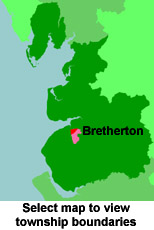
View a map of the boundaries of this town/parish.
You can see maps centred on OS grid reference SD482201 (Lat/Lon: 53.675036, -2.786203), Bretherton which are provided by:
- OpenStreetMap
- Google Maps
- StreetMap (Current Ordnance Survey maps)
- Bing (was Multimap)
- Old Maps Online
- National Library of Scotland (Old Ordnance Survey maps)
- Vision of Britain (Click "Historical units & statistics" for administrative areas.)
- English Jurisdictions in 1851 (Unfortunately the LDS have removed the facility to enable us to specify a starting location, you will need to search yourself on their map.)
- Magic (Geographic information) (Click + on map if it doesn't show)
- GeoHack (Links to on-line maps and location specific services.)
- All places within the same township/parish shown on an Openstreetmap map.
- Nearby townships/parishes shown on an Openstreetmap map.
- Nearby places shown on an Openstreetmap map.
For probate purposes prior to 1858, Bretherton was in the Archdeaconry of Chester, in the Diocese of Chester. The original Lancashire wills for the Archdeaconry of Chester are held at the Lancashire Record Office.
You can also see Family History Societies covering the nearby area, plotted on a map. This facility is being developed, and is awaiting societies to enter information about the places they cover.