
Hide
Warrington
hide
Hide
hide
Hide
hide
Hide
Hide
WARRINGTON, a town, a township, a parish, and a district, in Lancashire. The town stands on the river Mersey, at an intersection of railways, near the Sankey and the Bridgewater canals, 18 miles by road E of Liverpool. The township of W. comprises 2,507 acres. Real property, £67,188; of which £751 are in ironworks, £57 in canals, £164 in railways, and £2,096 in gasworks. Pop. in 1851, 20,800; in 1861, 24,050. Houses, 4,571. The parish contains also the townships of Burtonwood, Poulton-with-Fearnhead, Woolston-with-Martinscroft, and Rixton-with-Glazebrook; and comprises 12,168 acres. Pop. in 1851, 23,651; in 1861, 26,960. Houses, 5,138. The manor came to the Botelers in the time of Henry III.; passed to the Earl of Leicester in the time of Elizabeth; went afterwards through many hands; and belongs now to J. I. Blackburne, Esq. The living of St. Elphin is a rectory; and the livings of Trinity, St. Paul and St. Ann are p. curacies, in the diocese of Chester. Value of St. E., £1,300;* of T., £135; of St. P., £210;* of St. A., £300. Patron of St. E., Lord Lilford; of T., the Bishop of Sodor and Man; of St. P., the Hon. L. Powys; of St. A., W. Beamont, Esq. The p. curacies of Burtonwood, Hollinfare, and Padgate are separate benefices. The district includes also three other parishes and two parts in Lancashire, and another parish and a part in Cheshire; and is divided into the sub-districts of Warrington, Latchford, Rixton, Sankey, Winwick, and Newton-in-Mackerfield. Acres, 29,984. Poor rates in 1863, £19,840. Pop. in 1851, 36,164; in 1861, 43,875. Houses, 8,223. Marriages in 1863, 373; births, 1,902, of which 107 were illegitimate; deaths, 1,580, of which 887 were at ages under 5 years, and 17 at ages above 85. Marriages in the ten years 1851-60, 3,948; births, 16,384; deaths, 9,581. The places of worship, in 1851, were 15 of the Church of England, with 9,823 sittings; 4 of Independents, with 970 s.; 2 of Baptists, with 408 s.; 2 of Quakers, with 655 s.; 2 of Unitarians, with 620 s.; 8 of Wesleyans, with 2,351 s.; 2 of Primitive Methodists, with 389 s.; 1 of Lady Huntingdon's Connexion, with 710 s.; 1 of Southcottians, with 80 s.; and 4 of Roman Catholics, with 1,287 s. The schools were 30 public day-schools, with 3,602 scholars; 36 private day-schools, with 1,161 s.; 37 Sunday schools, with 4,255 s.; and 4 evening schools for adults, with 142 s. more ...
John Marius Wilson, Imperial Gazetteer of England and Wales (1870-72)
Hide
The Local History Library, Warrington Library, Museum Street, Warrington WA1 1JB
Warrington Municipal Cemetery records are held at:
Walton Lea Crematorium,
Chester Road,
Higher Walton,
Warrington,
Cheshire.
(Tel 01925 267731).
| Manchester Rd Cemetery, Warrington |
| Cairo St Unitarian, Warrington |
| Warrington, St Alban, Roman Catholic |
| Buttermarket St, Warrington, Society of Friends |
Details about the census records, and indexes for Warrington.
Warrington Register Office holds records of births, marriages and deaths since 1837.
"STOCKTON, a hamlet in the parish of Warrington, hundred of West Derby, county Lancaster, 1 mile S.E. of Warrington, and 16 E. of Liverpool."
"ORFORD, a hamlet in the parish of Warrington, county Lancaster, 1 mile N. of Warrington."
"LITTLE SANKEY, a parcel in the township and parish of Warrington, hundred of West Derby, county Lancaster, 3 miles N.W. of Warrington."
"HOWLEY, a tything in the parish of Warrington, hundred of West Derby, county Lancaster, 2 miles from Warrington. It is situated near the river Mersey, and the Sankey and Bridgwater canals."
"BIRCH, a hamlet in the parish of Warrington, hundred of West Derby, in the county palatine of Lancaster, not far from Warrington."
- Ask for a calculation of the distance from Warrington to another place.
ENG-LAN-WARRINGTON is an e-mail list for anyone with a genealogical interest in Warrington.
In 1835 the parish of Warrington contained the townships of Warrington, Rixton with Glazebrook, Woolston and Martincroft, Poulton with Fearnhead and Burtonwood.
In 1974 Warrington was moved into Cheshire.
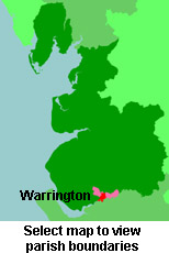
View maps of Warrington and places within its boundaries.
View a map of the boundaries of this town/parish.
You can see maps centred on OS grid reference SJ601889 (Lat/Lon: 53.395172, -2.601523), Warrington which are provided by:
- OpenStreetMap
- Google Maps
- StreetMap (Current Ordnance Survey maps)
- Bing (was Multimap)
- Old Maps Online
- National Library of Scotland (Old Ordnance Survey maps)
- Vision of Britain (Click "Historical units & statistics" for administrative areas.)
- English Jurisdictions in 1851 (Unfortunately the LDS have removed the facility to enable us to specify a starting location, you will need to search yourself on their map.)
- Magic (Geographic information) (Click + on map if it doesn't show)
- GeoHack (Links to on-line maps and location specific services.)
- All places within the same township/parish shown on an Openstreetmap map.
- Nearby townships/parishes shown on an Openstreetmap map.
- Nearby places shown on an Openstreetmap map.
The Workhouse site has an interesting description of Warrington workhouse.
For probate purposes prior to 1858, Warrington was in the Archdeaconry of Chester, in the Diocese of Chester. The original Lancashire wills for the Archdeaconry of Chester are held at the Lancashire Record Office.
- Liverpool & Southwest Lancashire Family History Society - Warrington Group
- Lancashire Parish Register Society
You can also see Family History Societies covering the nearby area, plotted on a map. This facility is being developed, and is awaiting societies to enter information about the places they cover.