
Hide
Althorpe
hide
Hide
hide
Hide
hide
Hide
Hide
Hide
The Scunthorpe Library is an excellent resource with a Local History section.
- Jonathan THACKER has a photograph of the Althorpe and Keadby burial ground on Geo-graph, taken in November, 2010.
- Althorpe was part of the Crowle sub-district in the Thorne Registration District.
- In addition to the standard census records, the Lincolnshire Archives hold special census returns that were taken in 1850 and 1853.
- Check our Census Resource page for county-wide resources.
- The Lincolnshire Family History Society has published surname indexes on fiche or in booklet form for each of these census years under the title "Gainsborough with Isle of Axholme". These are available by credit card from the Federation of Family History Societies Bookstore with worldwide shipping. Please note that these are SURNAME indexes only, and do not show first names, age or relationships. The table below gives census piece numbers, where known:
Census
YearLDS Film/Fiche
No.Piece No. LFHS Surname Index 1841 0438760 H.O. 107 / 626 Fiche 1851 0087609 H.O. 107 / 21xx Booklet 1861 0543146 R.G. 9 / 3526 Fiche 1871 0847320 R.G. 10 / 34xx Booklet 1881 1342136 R.G. 11 / 329x 1891 6098980, 3 fiche R.G. 12 / 3870 Booklet or Fiche
| St Mark, Althorpe, Church of England |
| St Oswald, Althorpe, Church of England |
| St Thomas a Becket, Althorpe, Church of England |
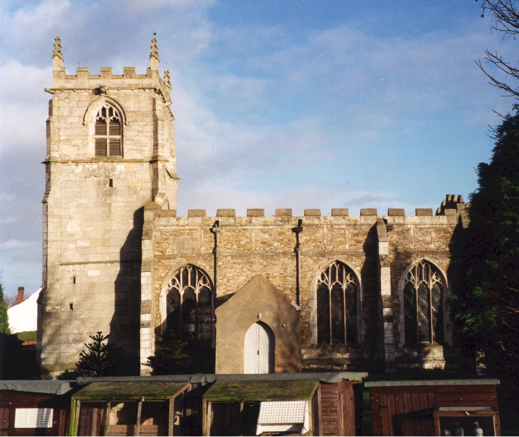
- The Anglican parish church is dedicated to Saint Oswald and was erected in 1483 by Sir John NEVILLE, during the reign of Edward IV.
- An additional churchyard was consecrated in 1856.
- The church seats 250.
- There is a photograph of St. Oswald's Church on the Wendy PARKINSON web site under her "Still more Lincolnshire churches".
- Here is a photograph St. Oswald's Church supplied by Ron COLE (who retains the copyright):
- Anglican parish registers are on deposit from 1672 - 1975, but Bishop's transcript entries go back to 1599.
- The Family History Library in Salt Lake City has the parish register on microfilm covering 1672 to 1975 and the Bishop's Transcript from 1599 to 1836 on another microfilm.
- Althorpe is in the Isle of Axholme Deanery.
- The Wesleyan Methodists built a chapel here in 1834 and the Primitive Methodists built their's at Derrythorpe in 1868. For information and assistance in researching these chapels, see our non-conformist religions page.
- "Marathon" has a photograph of Althorpe Methodist Church on Geo-graph, taken in September, 2019.
- Check our Church Records page for county-wide resources.
- The parish was in the Crowle sub-district in the Thorne Registration District.
- Check our Civil Registration page for sources and background on Civil Registration which began in July, 1837.
Althorpe is one of the eight original parishes in the Isle of Axholme in the far north-west corner of Lincolnshire. This village, township and parish lies on the west bank of the River Trent about a mile north of the M180 Mortorway and about four miles west of Scunthorpe. The parish includes the small town of Keadby and the hamlet of Derrythorpe. Until 1850, Amcotts was also part of Althorpe parish.
Agriculture, in the form of grain and market greens, is the principle industry in the parish.
If you are planning a visit:
- Visit our touring page for more sources.
- Ask for a calculation of the distance from Althorpe to another place.
- See the histories and descriptions of Althorpe and Amcotts provided by the Isle of Axholme FHS.
- John LANGLEY, a native of Althorpe, was lord mayor of London in 1576.
- The Hull and Gainsborough steamers passed by the village daily, stopping at Burringham and Keadby.
- Keadby used to be a terminus of the Keadby-Stainforth canal built in 1782 and a link to the railways. The canal ceased commercial operation in the 1970's.
- J. THOMAS has a photograph of The Dolphin Pub. on Geo-graph, taken in August, 2011.
- See our Maps page for additional resources.
You can see maps centred on OS grid reference SE834096 (Lat/Lon: 53.576378, -0.741913), Althorpe which are provided by:
- OpenStreetMap
- Google Maps
- StreetMap (Current Ordnance Survey maps)
- Bing (was Multimap)
- Old Maps Online
- National Library of Scotland (Old Ordnance Survey maps)
- Vision of Britain (Click "Historical units & statistics" for administrative areas.)
- English Jurisdictions in 1851 (Unfortunately the LDS have removed the facility to enable us to specify a starting location, you will need to search yourself on their map.)
- Magic (Geographic information) (Click + on map if it doesn't show)
- GeoHack (Links to on-line maps and location specific services.)
- All places within the same township/parish shown on an Openstreetmap map.
- Nearby townships/parishes shown on an Openstreetmap map.
- Nearby places shown on an Openstreetmap map.
- The ex-servicemen of Althorpe erected the column of granite as a memorial to their comrades who died in the Great War.
- Richard CROFT has a photograph of the War Memorial on Geo-graph, taken in July, 2007.
- Jonathan THACKER also has a photograph of the War Memorial on Geo-graph, taken in November, 2010.
For a photograph of the Althorpe War Memorial and the list of names on the pylon, see the Roll of Honour site.
There is one Commonwealth War Grave in the churchyard from World War I and two from World War II:
- H. BURTON (Should be Herbert BARTON), priv., age 19, 3rd Btn. Linc. Rgt., died 11 Apr. 1917. Son of Richard and Sarah BARTON of Belton.
- Cyril MAUD, gunner, age 37, Royal Art., died 15 May 1946, husband of Kathleen W. MAUD.
- Cyril OLDFIELD, priv., age 43, Home Guard, died 4 July 1943, son of J. H. and Kate OLDFIELD.
- The name Althorpe is from the Old Scandinavian ali+thorpe, meaning "farmstead of a man called Ali." In the 1086 Domesday Book it is rendered as Aletorp.
[A. D. MILLS, "A Dictionary of English Place-Names," Oxford University Press, 1991]
- The parish was in the western division of the ancient Manley Wapentake in the West Lindsey district in the parts of Lindsey.
- In 1850, Amcotts parish was formed from the northeast portion of Althorpe parish.
- Some records indicate that Keadby may have been its own parish before 1800. Keadby was incorporated as a separate Civil Parish in 1881 and was abolished as such in April, 1958.
- In April, 1958, the Civil Parish of Althorpe was abolished and a new Civil Parish of Keadby with Althorpe was formed.
- In the 1972 redistricting, Althorpe became part of the Boothferry District, which is now in the County of Humberside (formerly Lindsey, Lincolnshire).
- For today's district governance, see the North Lincolnshire Council website.
- Jonathan CLITHEROE has a photograph of the Memorial (village) Hall on Geo-graph, taken in February, 2016. Stop in when they are open and ask to see the schedule of forth-coming events.
- After the Poor Law Amendment Act reforms of 1834 the parish became part of the Thorne Poor Law Union
- Bastardy cases would be heard in the Epworth petty session hearings.
- A school board was formed on 18 Dec. 1874.
- A local public elementary school was built in 1876 and replaced by a modern building in 1975.
- For more on researching school records, see our Schools Research page.
- The local genealogical society is the Isle of Axholme FHS.