
Hide
Llanmaes
hide
Hide
hide
Hide
hide
Hide
Hide
"A village four miles south from, and in the hundred of Cowbridge. The church contains some mural frescoes. Near it are the ruins of Malafant Castle" [Glamorganshire, 1911]
Hide
Here is a substantial reading list of books which relate to Glamorgan, either county or parish.
The Glamorgan Family History Society have produced a set of microfiche containing Monumental Inscriptions for the following burial grounds :-
- Parish Church of St. Catwg
| St Cattwg'S , Llanmaes |
| Sunday School, Gadlys |
Glamorgan Chapels Database - no non-conformist chapels found in this parish
For full and up-to-date details of their holdings see the sites of Glamorgan Record Office and/or West Glamorgan Archives
See Bap/Mar/Bur data on FreeReg
The church is dedicated to St. Catwg, and is in the Benefice of Llantwit Major. Details of the present incumbent of this benefice can be found at the Church in Wales website. The church can be located at grid reference SS981694.
| Anglican Parish Registers Held at the Glamorgan Record Office, Cardiff | ||||
| Baptisms | Marriages | Burials | Banns | Bishops Transcripts |
| 1583-1988 | 1584-1812, 1814-1836, 1838-1968 | 1583-1988 | 1872-1987 | 1721, 1723-1730, 1732-1752, 1754-1776, 1778-1837 |
Details of extant records on Archives Network Wales for the following;
- Llanmaes Ecclesiastical Parish records "......... including copy registers of baptisms, 1766-1812; marriages, 1754-1812; combined baptisms, marriages and burials, 1583-1769"
The following Religious Institutions are covered in the Mormon International Genealogical Index (IGI) :-
- Llanmaes, St. Catwg - Christenings (BT's), 1796-1871
Conservation areas within the Vale of Glamorgan. See Llanmaes - "Conservation areas are areas of special architectural or historic interest, the character or appearance of which it is desirable to preserve or enhance"
Various landscapes - on the People's Collection Wales site
Transcript of complete name listing for Llantwit Major, with Llanmaes, St. Donats and neighbourhoods Slaters Directory for 1880.
The transcription of the section for Llanmaes from The National Gazetteer (1868) provided by Colin Hinson.
Descriptions of parish
A Topographical Dictionary of Wales (1833) by Samuel Lewis.
A Topographical Dictionary of The Dominion of Wales by Nicholas Carlisle, London, 1811.
- Ask for a calculation of the distance from Llanmaes to another place.
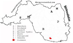
This diagram shows the position of this parish within the county of Glamorgan - click on this to see a full size diagram of the county
|
Parish map (Kain/Oliver)
You can see maps centred on OS grid reference SS990702 (Lat/Lon: 51.421636, -3.453913), Llanmaes which are provided by:
- OpenStreetMap
- Google Maps
- StreetMap (Current Ordnance Survey maps)
- OpenStreetMap Cymru (Welsh counties only)
- Bing (was Multimap)
- Old Maps Online
- National Library of Scotland (Old Ordnance Survey maps)
- Vision of Britain (Click "Historical units & statistics" for administrative areas.)
- Magic (Geographic information) (Click + on map if it doesn't show)
- GeoHack (Links to on-line maps and location specific services.)
- All places within the same township/parish shown on an Openstreetmap map.
- Nearby townships/parishes shown on an Openstreetmap map.
- Nearby places shown on an Openstreetmap map.
Places, villages, farms etc within Llanmaes parish as shown on the online parish map from the CD of Historic Parishes of England and Wales: an Electronic Map of Boundaries before 1850 with a Gazetteer and Metadata [computer file]. (Kain, R.J.P., Oliver, R.R.). (Extracted by Glenys Travis)
- Llanmaes [166] - Boverton Bk, The Butts, Domen-fawr, Froglands, Gadlys, Great Frampton, Llanmaes, Picketston, Rectory.
There are many references to this area in the 15 million Welsh and English language articles from Welsh newspapers transcribed by the NLW and viewable on Welsh Newspapers Online
Below are English language articles that have been re-transcribed and extracted randomly to illustrate what is available, there are many that are not extracted here that include names of local people
- From the Barry Dock News 11th November 1892
LLANMAES. ENTERTAINMENT.—On Tuesday evening last a capital entertainment was provided at the schoolroom on behalf of the school funds. The first part consisted of the piece, "Beauty and the Beast", and the after parts, "Mrs Jarley's Waxworks," and "The Rival Barber's Shop." Rev D. Evans also gave recitations.
- From the Barry Dock News 22nd June 1894
LLANMAES. CHURCH DEFENCE.— On Thursday evening the 14th. inst., a public meeting took place at the Parish School, Llanmaes, when the Rev. S. H. F. Nicholl (rural dean) presided. After addresses by the Rev. D. E. Ll Jones, of Llandow, and the Rev. D. Evans, rector of the parish, the following resolution was unanimously carried:- "That this meeting of the inhabitants of Llanmaes desires to protest against the Bill for the disestablishment of the Church in Wales as an unjust and cruel measure."
- From The Glamorgan Gazette 14th December 1906
LLANMAES. Tea and Entertainment.—A very enjoyable tea was given at Llanmaes Schoolroom on Wednesday, November 28th, by the ladies of the parish, followed by an entertainment provided chiefly by the children. It was held in connection with the opening of a village club for men and boys. The Rev. D. Evans, M.A., rector of Llanmaes, delivered a short address, in which he referred to the benefits likely to be derived from a club in the parish, and dwelt pointedly upon the evils of gambling. .....(part extract).....
- From the Evening Express (Third Edition) 19th September 1904
FIRE AT LLANMAES STUD FARM. Information was sent to the Cardiff, Fire Brigade on Sunday morning that a large rick of hay consisting of about 150 tons was on fire at Llanmaes Stud Farm, St. Fagan's, the property of Mr. James Howell, draper, Cardiff. The manual engine was despatched in charge of two firemen, and it was found on their arrival that the rick was well alight. The engine was got to work from a pond about 500ft. from the conflagration, and, with plenty of assistance, the manual continued working until seven o'clock in the evening by which time the fire had been practically got under. The amount of the damage is estimated at about £ 450. The cause of the fire is unknown. The rick was situated in a field some distance from the farm buildings, so that there was no danger of the conflagration spreading.
The Population of Llanmaes was as follows, and a more detailed breakdown is available.
| 1841 - 194 | 1851 - 183 | 1861 - 164 | 1871 - 148 | 1881 - 147 | 1891 - 130 |
Details of extant records on Archives Network Wales for the following;
- Llanmaes Civil Parish records " ......... comprising tithe plan and apportionment, 1843; copy of redemption of land tax on glebe, 1824"