
Hide
Landkey
hide
Hide
hide
- Almanacs◬
- Archives & Libraries◬
- Bibliography◬
- Biography◬
- Business & Commerce Records◬
- Cemeteries
- Census
- Chronology◬
- Church History
- Church Records
- Churches
- Civil Registration◬
- Correctional Institutions◬
- Court Records◬
- Description & Travel
- Directories
- Emigration & Immigration◬
- Encyclopaedias & Dictionaries◬
- Folklore◬
- Gazetteers
- Genealogy
- Handwriting◬
- Heraldry◬
- Historical Geography◬
Hide
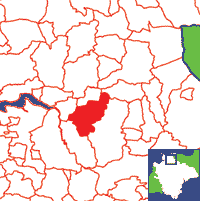
Click on map to view parish boundaries in detail.
Hide
Hide
hide
- History
- Jewish History◬
- Land & Property
- Language & Languages◬
- Manors◬
- Maps
- Medical Records◬
- Merchant Marine◬
- Military History◬
- Names, Geographical◬
- Names, Personal◬
- Newspapers◬
- Occupations◬
- Periodicals◬
- Politics & Government◬
- Poor Houses, Poor Law◬
- Population◬
- Probate Records
- Schools◬
- Social Life & Customs◬
- Societies◬
- Taxation◬
- Voting Registers◬
Hide
"LANDKEY (HOLY TRINTY), a parish, in the union of BARNSTAPLE, hundred of SOUTH MOLTON, South Molton and N. divisions of DEVON, 2¼ miles (E. S. E.) from Barnstaple; containing 774 inhabitants This parish, which is situated on the road from Barnstaple to South Molton, comprises by computation 2400 acres: limestone of good quality is abundant, and there are two quarries of considerable extent. The living is a perpetual curacy, with that of Swimbridge annexed; net income, £179; patron and appropriator, Dean of Exeter. The church contains a handsome monument to one of the Acland family. At Herford, in the parish, was anciently a chapel. Here is a place of worship for Wesleyans; also a small school supported by charity. [From Lewis' Topographical Dictionary of England (1844)]
A parish in South Molton Hundred, under the Peculiar jurisdiction of the Bishop of Exeter.
Hide
MIs for this parish are included in the Incledon index - see under Cemeteries on the main Devon page.
Index to Transcription of the MIs on the gravestones in the churchyard, by David Ryall.
Snetzler, M.F. North Devon Surname Index to the Census. Microfiche: M.F. Snetzler. [Covers 1841, 1861, 1871 and 1881 census records for this parish]
| St Paul, Landkey, Church of England |
Landkey Parish church is in fact dedicated to St Paul - see note.
Parish Registers going back to 1602 are held in the Devon Record Office.
Transcripts of the Parish Registers going back to 1602 are held in a special collection in the Westcountry Studies Library.
The Devon FHS publishes indexes covering (as of June 2004): Marriages 1754-1837, Burials 1813-1837 - for details see their Devon Parish List.
Other churches and chapels (with pre-1840 records):
- Wesleyan Chapel: Registers for 1816-37 (ZC) in PRO RG 4/1213; 1816-69 (C), 1994 (M), 1848-68 (B) in NDRO; 1816-37 - see also Barnstaple Circuit, Bideford (PRO RG 4/954, 955)
Entered into the IGI: Parish Church Chr (1602-1850) and mar (1602-1837) Wesleyan Chr (1813-1837).
Deanery of Barnstaple - Baptisms 1813-1839, Marriages 1754-1837 and Burials 1813-1837 - CD-ROM, Exeter, Devon FHS (2005). [Index of Atherington: Baptisms (1813-1839), Marriages (1754-1837), Burials (1800-1837), Barnstaple: Baptisms (1813-1839), Marriages (1754-1837), Burials (1813-1837), Bishops Tawton: Baptisms (1813-1839), Marriages (1754-1837), Burials (1813-1837), Chittlehampton: Baptisms (1813-1839), Marriages (1754-1837), Burials (1813-1837), Filleigh: Baptisms (1813-1839), Marriages (1754-1837), Burials (1813-1837), Fremington: Baptisms (1813-1839), Marriages (1754-1837), Burials (1813-1837), High Bickington: Baptisms (1813-1839), Marriages (1754-1837), Burials (1813-1837), Horwood: Baptisms (1813-1839), Marriages (1654-1837), Burials (1675-1837), Huntshaw: Baptisms (1813-1839), Marriages (1754-1837), Burials (1813-1837), Instow: Baptisms (1813-1839), Marriages (1754-1837), Burials (1813-1837), Landkey: Baptisms (1813-1839), Marriages (1754-1837), Burials (1813-1837), Newton Tracey: Baptisms (1813-1839), Marriages (1570-1837), Burials (1725-1837), Pilton: Baptisms (1813-1839), Marriages (1754-1837), Burials (1813-1837), Swimbridge: Baptisms (1813-1839), Marriages (1754-1837), Burials (1813-1837), Tawstock: Baptisms (1813-1839), Marriages (1754-1837), Burials (1813-1837), Westleigh: Baptisms (1813-1839), Marriages (1754-1837), Burials (1813-1838) [Lookups]
Section on Landkey from Samuel Lewis: A Topographical Dictionary of England (1831), provided by Mel Lockie.
Transcript of complete entry in White's Devonshire Directory of 1850.
Transcription, by Jonathan Frayne of the Landkey section of Kelly's Directory of Barnstaple and Neighbourhood (1941).
The transcription of the section for this parish from the National Gazetteer (1868), provided by Colin Hinson.
- Ask for a calculation of the distance from Landkey to another place.
The Online Parish Clerk scheme's representative for this parish is Ann O'Toole, who invites queries and lookup requests. (Resources: PRs on fiche, indexed.)
Hambly, Marilyn. Lieutenant William Edward Hambly, Devon Family Historian, vol. 164, (2017) pp.14-15. [b. Landkey 1894, served in the 4th Devons in India and Mesopotamia during WW1, then with the Indian Army, but died in India of pneumonia aged 25, soon after marrying Marjorie Balfour.]
Underwood, Barry. The Shapland family.: Barry Underwood, Corona, CA, USA (1965) 93, [10]p: portraits. [ISBN 0961479000]
Underwood, Barry. The ancestry of Christopher Shapland 1838-1928: native of Devonshire, England. Barry Underwood, Corona, CA, USA (1995) 30p. [Barnstaple Library - 929.2/SHA]
"The Discovering Landkey Group", Tales of Old Landkey, 1 Bowden's Cottages, Blakeshill road, Landkey, North Devon.
Discovering Landkey: a community catalogue. Beaford: Beaford Arts Centre (1996) [4], 116p: ill, maps. [ISBN 1855225123]
Elliot, John. Devon homes - Acland Barton, Landkey. Devon Life vol. 10 no. 90 (1973) pp.30-31; ill.
Index of heads of Households in Devonshire: Landkey A-L, P.O. Box 339, Blackburn, Victoria, Australia 3130, Australian Institute of Genealogical Studies (2000). [As recorded in Land Tax records 1780-1831]
Index of heads of Households in Devonshire: Landkey M-Z, P.O. Box 339, Blackburn, Victoria, Australia 3130, Australian Institute of Genealogical Studies (2000). [As recorded in Land Tax records 1780-1831]
View a map of the boundaries of this town/parish.
You can see maps centred on OS grid reference SS590311 (Lat/Lon: 51.061874, -4.013499), Landkey which are provided by:
- OpenStreetMap
- Google Maps
- StreetMap (Current Ordnance Survey maps)
- Bing (was Multimap)
- Old Maps Online
- National Library of Scotland (Old Ordnance Survey maps)
- Vision of Britain (Click "Historical units & statistics" for administrative areas.)
- English Jurisdictions in 1851 (Unfortunately the LDS have removed the facility to enable us to specify a starting location, you will need to search yourself on their map.)
- Magic (Geographic information) (Click + on map if it doesn't show)
- GeoHack (Links to on-line maps and location specific services.)
- All places within the same township/parish shown on an Openstreetmap map.
- Nearby townships/parishes shown on an Openstreetmap map.
- Nearby places shown on an Openstreetmap map.
Wills of John Ackland (1538) and John Ackland (1553) transcribed by Debbie Kennett.
Will of Giles Mallett (1697) transcribed by Mike Mallett.
Will of Ann Joce (1799) transcribed by David Davy.