
Hide
Denton
hide
Hide
hide
Hide
hide
Hide
Hide
DENTON is a township in the parish of Manchester, extending 3 to 4 miles south-west from Ashton-under-Lyne to the Cheshire border of the county, with a station on the Stockport and Stalybridge branch of the London and North Western railway, 6 miles south-east from Manchester and 4½ north-east from Stockport, in the Gorton division of the county, hundred of Salford, union and petty sessional division of Ashton-under-Lyne, county court district of Hyde (Cheshire), rural deanery of Ashton-under-Lyne, archdeaconry and diocese of Manchester. By a Local Government Board Order, dated 10 April, 1884, Haughton, as a separate township, ceased to exist, and was incorporated with, that of Denton, a Local Board was formed March 24, 1867, with 3 members, and increased to 15 in 1877 on the amalgamation with Haughton. Under the Local Government Act, 1894, the township is now governed by an Urban District Council. The district is lighted with gas from works the property of the Urban Council.
This place has been from an early period the seat of the felt hat manufacture, the staple trade of the place. Coal mining is also extensively carried on. The Free Library, in Albert street, erected in 1888-9, in commemoration of the queen's jubilee, at a total cast of £2,700, is of red brick, in the Italian style and comprises on the ground floor a large reading room, library and reference room containing 2,000 volumes and residence for the librarian, and on the first floor, rooms for science and art classes; the library is managed by the Urban Council; adjoining the library are recreation grounds of about 5 acres laid out by the board at a cost of £5,000. Tho Conservative Club in Manchester road, opened by Sir William H. Houldsworth M.P. in 1892, is a structure of Accrington pressed bricks with ornamental cornices, relieved with Yorkshire stone dressings. It contains a large assembly hall, reading, billiard and other rooms, and is fitted with every modern improvement; the architect was Mr. T. D. Lindley, of Ashton-under-Lyne; the total cost was about £2,300: it has now (1894) 350 members. The Liberal Club, opened in 1894 was erected at a cost of nearly £3,000, and is a building of brick relieved with stone dressings. It contains a large public hall and ample accommodation for 400 members; the architect was Mr. Joseph Lindley, of Hyde.
The Manchester Corporation have extensive reservoirs here, covering upwards of 378 acres and capable of containing 1,800,000,000 gallons. The population of Denton township in 1871 was 5,117; in 1881, 7,660; in 1891, 8,660; estimated population of Denton (including Haughton) to June, 1894, 14,378. The acreage (including Haughton) is 2,599 acres, of which 24 are water; rateable value, £51,203; the population of Denton and Haughton Urban Council district in 1891 was 13,993.
from Kelly's directory of Lancashire, 1895
Hide
Denton local studies information is held at Tameside local studies library, Ashton.
| Christ Church, Denton, Church of England |
| St Lawrence originally St James, Denton, Church of England |
| Hope Congregational, Denton |
| Denton Cemetery |
Details about the census records, and indexes for Denton.
| Christ Church, Denton, Church of England |
| St George, Denton, Church of England |
| St Lawrence originally St James, Denton, Church of England |
| Hope Congregational, Denton |
| Denton Cemetery |
| Wilton Street, Unitarian, Denton |
The Register Office covering the Denton area is Tameside.
Tameside Metropolitan Borough Council provide a range of information about the town.
The National Gazetteer of Great Britain and Ireland - 1868
"DENTON, a chapelry in the parish of Manchester, hundred of Salford, in the county of Lancaster, 3½ miles S.W. of Ashton-under-Lyne, and 4 N.E. of Stockport. It is situated W. of the river Tame, and is a station on the Stockport and Staleybridge branch of the Manchester and Leeds railway. The chief business of the inhabitants is hat-making. There are extensive coal-mines. The living is a perpetual curacy in the diocese of Manchester, value £135, in the patronage of the Marquis of Westminster. The church is dedicated to St. James. There is another church called Christ Church, the living of which is a perpetual curacy, value £130, in the patronage of the crown and bishop alternately. The Wesleyans have a chapel. Denton Hall, once the family seat of the Hollands, is now a farm."
- Ask for a calculation of the distance from Denton to another place.
In 1835 Denton was a township and chapelry in the parish of Manchester.
View maps of Denton and places within its boundaries.
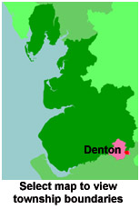
View a map of the boundaries of this town/parish.
You can see maps centred on OS grid reference SJ913949 (Lat/Lon: 53.450479, -2.132136), Denton which are provided by:
- OpenStreetMap
- Google Maps
- StreetMap (Current Ordnance Survey maps)
- Bing (was Multimap)
- Old Maps Online
- National Library of Scotland (Old Ordnance Survey maps)
- Vision of Britain (Click "Historical units & statistics" for administrative areas.)
- English Jurisdictions in 1851 (Unfortunately the LDS have removed the facility to enable us to specify a starting location, you will need to search yourself on their map.)
- Magic (Geographic information) (Click + on map if it doesn't show)
- GeoHack (Links to on-line maps and location specific services.)
- All places within the same township/parish shown on an Openstreetmap map.
- Nearby townships/parishes shown on an Openstreetmap map.
- Nearby places shown on an Openstreetmap map.
For probate purposes prior to 1858, Denton was in the Archdeaconry of Chester, in the Diocese of Chester. The original Lancashire wills for the Archdeaconry of Chester are held at the Lancashire Record Office.
You can also see Family History Societies covering the nearby area, plotted on a map. This facility is being developed, and is awaiting societies to enter information about the places they cover.