
Hide
Haydock
hide
Hide
hide
Hide
hide
Hide
Hide
Haydock, township and vil., Ashton in Makerfield par., SW. Lancashire, 3½ miles NE. of St Helens, 2409 ac., pop. 5863; P.O., T.O.; has ironfounding and extensive collieries; in vicinity is Haydock Lodge, now used as a lunatic asylum.
John Bartholomew, Gazetteer of the British Isles (1887)
Hide
Details about the census records, and indexes for Haydock.
| St James, Haydock, Church of England |
| St Mark Church of England, Haydock |
| St Paul, Blackbrook, Church of England |
| Clipsley Lane, Haydock, Baptist |
| Haydock, Christ Church, Congregational |
| Clipsley Lane, Wesleyan Methodist, Haydock |
| West End Rd, Blackbrook, Independant Methodist |
| West End Road, Haydock, Primitive Methodist |
| The Blessed English Martyrs, Haydock, Roman Catholic |
The National Gazetteer of Great Britain and Ireland - 1868
"HAYDOCK, a township in the parish of Winwick, county Lancaster, 2 miles W. of Newton. It is a considerable village, most of the inhabitants being engaged in the mines and collieries."
- Ask for a calculation of the distance from Haydock to another place.
In 1835 Haydock was a township in the parish of Winwick.
View maps of Haydock and places within its boundaries.
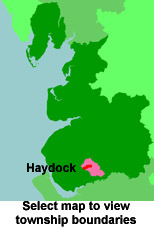
View a map of the boundaries of this town/parish.
You can see maps centred on OS grid reference SJ566969 (Lat/Lon: 53.467081, -2.655961), Haydock which are provided by:
- OpenStreetMap
- Google Maps
- StreetMap (Current Ordnance Survey maps)
- Bing (was Multimap)
- Old Maps Online
- National Library of Scotland (Old Ordnance Survey maps)
- Vision of Britain (Click "Historical units & statistics" for administrative areas.)
- English Jurisdictions in 1851 (Unfortunately the LDS have removed the facility to enable us to specify a starting location, you will need to search yourself on their map.)
- Magic (Geographic information) (Click + on map if it doesn't show)
- GeoHack (Links to on-line maps and location specific services.)
- All places within the same township/parish shown on an Openstreetmap map.
- Nearby townships/parishes shown on an Openstreetmap map.
- Nearby places shown on an Openstreetmap map.
At least 204 people were killed in an explosion at the Wood Pit in 1878. A list of the victims has been provided from Ian Winstanley's book Weep Mother's Weep.
For probate purposes prior to 1858, Haydock was in the Archdeaconry of Chester, in the Diocese of Chester. The original Lancashire wills for the Archdeaconry of Chester are held at the Lancashire Record Office.
You can also see Family History Societies covering the nearby area, plotted on a map. This facility is being developed, and is awaiting societies to enter information about the places they cover.