
Hide
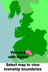
Winwick with Hulme
hide
Hide
hide
Hide
hide
Hide
Hide
WINWICK, a township, a parish, and a sub-district, in Warrington district, Lancashire. The township lies 2 miles S by E of Newton r. station, and 2½ N of Warrington; bears the name of W.-with-Hulme; and has a post-office under Newton-le-Willows. Acres, 1,431. Real property, £3,579. Pop., 451. Houses, 87. The parish includes Houghton, Middleton, and Arbury township; and comprises 2,270 acres. Pop., 704. Houses, 132. The property is much subdivided. W. Hall is the seat of the Rev. F. G. Hopwood. The living is a rectory in the diocese of Chester. Value, not reported. Patron, the Earl of Derby. The church is chiefly ancient; was partly rebuilt in 1848, and extensively improved in 1858; and has a tower, with octagonal spire. There is an endowed grammar-school with £34 a year. The sub-district includes Croft-with-Southworth parish.
John Marius Wilson, Imperial Gazetteer of England and Wales (1870-72)
Hide
Local studies information is held at Warrington library.
Details about the census records, and indexes for Winwick with Hulme.
The Register Office covering the Winwick area is Warrington.
The National Gazetteer of Great Britain and Ireland - 1868
"WINWICK, a parish in the hundred of West Derby, county Lancaster, 3 miles N. of Warrington, 2 S. of Newton-in-Mackerfield, and 3 S.W. of the Kenyon railway station, on the Manchester and Liverpool, and Kenyon and Leigh railways. It was once a populous parish, comprising near 25,000 acres, with a population of over 20,000, but has been much reduced by the erection of Ashton-in-Mackerfield, Newton-in-Mackerfield, and Southworth-with-Croft, into distinct parishes, so that the population of the parish proper in 1861 was only 704, and that of the township of Winwick-with-Hulme 451. The village of Winwick is situated on the turnpike road midway between Warrington and Newton-in-Mackerfield, not far from the Sankey canal, and the London and North-Western railway. According to some antiquarians, it was the ancient Maserfeld, where Oswald, king of Northumbria, was slain in 612; and at a place called Redbank, between the village of Winwick and the town of Newton, the Scots were defeated, in 1648, by Oliver Cromwell. The living is a rectory in the deanery of Warrington, archdeaconry of Liverpool and bishopric of Chester. The church, dedicated to St. Oswald, is supposed to be coeval with the establishment of the Christian religion in the country. It has two private chapels and a new chancel, added in 1847. In the interior are an inscription to St. Oswald, two ancient brasses of Sir P. Legh, of Lyme, with effigies bearing date 1527, and one to Gerard Bryn of 1492, besides an antique font and four painted windows. There are a free Grammar school, founded by Gualter Legh in 1618, with an income from endowment of £34; a Sunday-school and church schools for both sexes, supported by the rector, the Rev. F. G. Hopwood, who is lord of the manor."
"HULME, a township in the parish of Winwick, county Lancaster, 3 miles N. of Warrington."
- Ask for a calculation of the distance from Winwick with Hulme to another place.
In 1835 the parish of Winwick contained the townships of Winwick with Hulme, Houghton, Middleton and Arbury, Southworth with Croft, Culcheth, Newton in Makerfield, Haydock, Ashton in Makerfield, Golborne, Lowton and Kenyon.
View maps of Winwick and places within its boundaries.
View a map of the boundaries of this town/parish.
You can see maps centred on OS grid reference SJ598923 (Lat/Lon: 53.426032, -2.605782), Winwick with Hulme which are provided by:
- OpenStreetMap
- Google Maps
- StreetMap (Current Ordnance Survey maps)
- Bing (was Multimap)
- Old Maps Online
- National Library of Scotland (Old Ordnance Survey maps)
- Vision of Britain (Click "Historical units & statistics" for administrative areas.)
- English Jurisdictions in 1851 (Unfortunately the LDS have removed the facility to enable us to specify a starting location, you will need to search yourself on their map.)
- Magic (Geographic information) (Click + on map if it doesn't show)
- GeoHack (Links to on-line maps and location specific services.)
- All places within the same township/parish shown on an Openstreetmap map.
- Nearby townships/parishes shown on an Openstreetmap map.
- Nearby places shown on an Openstreetmap map.
For probate purposes prior to 1858, Winwick was in the Archdeaconry of Chester, in the Diocese of Chester. The original Lancashire wills for the Archdeaconry of Chester are held at the Lancashire Record Office.
You can also see Family History Societies covering the nearby area, plotted on a map. This facility is being developed, and is awaiting societies to enter information about the places they cover.