
Hide
Darton
hide
Hide
hide
Hide
Hide
The Ancient Parish of DARTON
[Transcribed information mainly from the early 1820s]
"DARTON, a parish-town, in the wapentake of Staincross, liberty of Pontefract; 3½ miles NW. of Barnsley, 6 from Penistone, 8½ from Wakefield, 36½ from York. Pop. 1,340. The Church is a vicarage, dedicated to All-Saints (see Churches for photograph), in the deanry of Doncaster, value, ~£12. 10s. p.r. *£150. Patron, Godfrey Wentworth, Esq.A branch of the family of Beaumonts had formerly a seat here, at Darton Hall, of which family was George Beaumont, a merchant, who left considerable sums of money, to be employed in several charitable uses; particularly £500. for the founding of the Free Grammar School at this, his place of nativity, in 1675. Its annual value at present is about £120.
In the church, which is a beautiful structure, is a handsome marble monument to the memory of John Silvester, of Birthwaite Hall, which he purchased of the Burdett family. He was originally a blacksmith, and was the inventor of a curious chain made to go across the Thames. He died aged 70, in 1722."
Information on the following places in this Parish is contained on a supplementary page.
|
|
|
[Description(s) edited from various 19th century sources by Colin Hinson © 2013]
Hide
- The Barnsley Family History Society have the Monumental inscriptions for All Saints' Church, Darton for sale on the Genfair site.
- Here are photographs of Churches in the parish:
- All Saints' Church, Darton. (The Church's website is here.)
- The Church of St. Thomas, Gawber.
- The Church of St. John the Evangelist, Staincross. (The Church's website is here.)
- The Methodist Church, Higham.
- The Methodist Church, Barugh.
- The Methodist Church, Staincross.
- The Methodist Church, Kexbrough.
- The Outreach Christian Centre, Darton.
- Transcript of the entry for Darton in the "Collections relative to Churches and Chapels".
- The whereabouts and dates of the Registers etc. for the Parish of Darton.
- Transcript of the entry of "professions and trades" in the Baines's Directory and Gazetteer, Vol I, West Riding.
- There is further information about this parish from the Pigot's 1834 Directory, Yorkshire section.
- There is further information about this parish from the National Gazetteer 1868, Yorkshire extracts.
- There is further information about this parish from the Lewis's Topographical Dictionary of England, Yorkshire extracts.
- Ask for a calculation of the distance from Darton to another place.
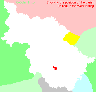
- For a detailed map of this parish see this parish boundaries map.
- For a more detailed map of the parishes in the riding please see the Yorkshire parish maps page.
- For a more detailed map of the county please see the Yorkshire map page.
- Here is a map showing the wapentakes for the county.
You can see maps centred on OS grid reference SE318005 (Lat/Lon: 53.500242, -1.522076), Darton which are provided by:
- OpenStreetMap
- Google Maps
- StreetMap (Current Ordnance Survey maps)
- Bing (was Multimap)
- Old Maps Online
- National Library of Scotland (Old Ordnance Survey maps)
- Vision of Britain (Click "Historical units & statistics" for administrative areas.)
- English Jurisdictions in 1851 (Unfortunately the LDS have removed the facility to enable us to specify a starting location, you will need to search yourself on their map.)
- Magic (Geographic information) (Click + on map if it doesn't show)
- GeoHack (Links to on-line maps and location specific services.)
- All places within the same township/parish shown on an Openstreetmap map.
- Nearby townships/parishes shown on an Openstreetmap map.
- Nearby places shown on an Openstreetmap map.
- The following places are within the boundaries of this (ancient) parish, but I have no further information on them other than the Ordnance Survey Landranger Grid reference shown:
- (SE312078) Barugh Green
- (SE312068) Higham Common
- (SE313087) Low Barugh
- (SE326074) Wilthorpe
- This parish is covered by the following Society:
- A list of those paying the 1379 Subsidy Rolls (Poll Tax) for this parish.