
Hide
Great Driffield
hide
Hide
hide
Hide
Hide
The Ancient Parish of GREAT DRIFFIELD
[Transcribed information mainly from the early 1820s]
"GREAT DRIFFIELD, a parish in the wapentake of Harthill, and liberty of St. Peter's; 12 miles from Bridlington, 13 from Beverley, 19 from Malton, 22 from Hull, 23 from Scarborough, 30 from York, and 192 from London by way of Lincoln. The population of this place is rapidly augmenting: in 1801, it amounted to 1329; in 1811, to 1857; and in 1821, to 2303, making an increase during each 10 years of about five and twenty per cent and the ratio of mortality, owing to the combined influence of the salubrious situation of the town and the healthful pursuits of the inhabitants, does not exceed one in sixty per annum." (There is further information for Great Driffield)."DANESDALE, in the parish of Great Driffield, and wapentake of Harthill; 2½ miles N. of Great Driffield. There are within one mile of this place a great number of Tumuli, amounting to about five hundred, which from time immemorial have been called " Danes Graves." History is silent concerning their origin, but it is highly probable that the Danes who appear to have had a fortified camp near Flamborough, may have issued from thence to ravage the country, and have fallen victims to Saxon valour. Each tumulus is three or four feet high, and from twenty to thirty feet in circumference at the base. Many of these ancient depositaries of the dead have been recently opened, and found to contain each a human skeleton, which from the dry calcareous nature of the soil has been kept in excellent preservation upwards of a thousand years."
"ELMSWELL, in the parish of Great Driffield, and wapentake of Harthill; 1½ miles W. of Great Driffield. Pop. with Kelleythorpe, 93."
"KELLEYTHORPE, in the parish of Great Driffield, and wapentake of Harthill; 1¼ miles SSW. of Great Driffield."
"KENDAL HOUSE, in the parish of Great Driffield, and wapentake of Harthill; 1½ miles NNW. of Great Driffield."
"LITTLE DRIFFIELD, in the parish of Great Driffield, and 1 mile from it to the North West." (There is further information for Little Driffield).
"WOLD HOUSE, a farm house in the township and parish of Great-Driffield; 3¼ miles NNW. of Great Driffield."
[Description(s) edited mainly from various 19th century sources by Colin Hinson. ©2010]
Hide
- Photographs of the over 3,400 gravestones in Driffield Cemetery with linked surname index.
- Photographs of the over 220 gravestones in Little Driffield Churchyard with linked surname index.
- Here are photographs of churches in the parish:
- All Saints' Church, Great Driffield. (The Church's website is here.)
- Internal view looking down the aisle
- The East Window
- The font
- The Methodist Church Sunday School, Great Driffield. (The Church's website is here.)
- The Methodist Church, Great Driffield.
- Bourne Primitive Methodist Church, Great Driffield.
- The Roman Catholic Church of our Lady and St. Edward, Great Driffield.
- Internal view looking down the aisle
- The Congregational Church, Great Driffield.
- Driffield Christian Fellowship, Great Driffield.
- St. Mary's Church, Little Driffield. (View 1)
- Internal view looking down the aisle
- The font
- St. Mary's Church, Little Driffield. (View 2)
- The former Methodist Church, Great Driffield.
- The Salvation Army, Great Driffield. (The Church's website is here.)
- The three mortuary chapels at Driffield cemetery:
- All Saints' Church, Great Driffield. (The Church's website is here.)
- A transcript of Driffield Baptist Church History up to 1912
- Transcript of the entry for Great Driffield in the "Collections relative to Churches and Chapels".
- Transcript of the entry for Little Driffield in the "Collections relative to Churches and Chapels".
- A transcript of Driffield Congregational Church History
- The whereabouts and dates of the Registers etc. for the Parish of Great Driffield.
- The whereabouts and dates of the Registers etc. for the Chapelry of Little Driffield.
- The List of Vicars in All Saints Church, Great Driffield.
- Transcript of the entry of "professions and trades" in the Baines's Directory of 1823, of the East Riding.
- Transcript of the entry of "professions and trades" in the Pigot's 1829 Directory, Yorkshire section.
- Transcript of the entry of "professions and trades" in the Pigot's 1834 Directory, Yorkshire section.
- Transcript of the entry of "professions and trades" in the White's Directory of 1840, Yorkshire section.
- Transcript of the entry of "professions and trades" in the Bulmers Directory of 1892. of the East Riding.
- There is further information about this parish from the Pigot's 1829 Directory, Yorkshire section.
- There is further information about this parish from the Pigot's 1834 Directory, Yorkshire section.
- There is further information about this parish from the National Gazetteer 1868, Yorkshire extracts.
- There is further information about this parish from the Lewis's Topographical Dictionary of England 1835, Yorkshire extracts.
- There is further information about this parish from the Stephen Whatley's Gazetteer 1750, Yorkshire extracts.
- There is further information about this parish from the Bulmer's 1892 History and Directory of the East Riding.
- Ask for a calculation of the distance from Great Driffield to another place.
- Available from Yorkshire Parish Registers as a downloadable purchase are a Collection of birth, marriage & death notices, indexed by surname. and a Collection of articles of local interest, indexed by surname (1861-1870). all taken from the Driffield Times.
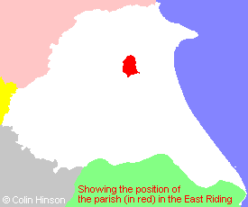
- For a detailed map of this parish see this parish boundaries map.
- For a more detailed map of the parishes in the riding please see the Yorkshire parish maps page.
- For a more detailed map of the county please see the Yorkshire map page.
- Here is a map showing the wapentakes for the county.
You can see maps centred on OS grid reference TA022580 (Lat/Lon: 54.007915, -0.442055), Great Driffield which are provided by:
- OpenStreetMap
- Google Maps
- StreetMap (Current Ordnance Survey maps)
- Bing (was Multimap)
- Old Maps Online
- National Library of Scotland (Old Ordnance Survey maps)
- Vision of Britain (Click "Historical units & statistics" for administrative areas.)
- English Jurisdictions in 1851 (Unfortunately the LDS have removed the facility to enable us to specify a starting location, you will need to search yourself on their map.)
- Magic (Geographic information) (Click + on map if it doesn't show)
- GeoHack (Links to on-line maps and location specific services.)
- All places within the same township/parish shown on an Openstreetmap map.
- Nearby townships/parishes shown on an Openstreetmap map.
- Nearby places shown on an Openstreetmap map.
- The World War I Memorial Plaque in All Saints Church, Driffield
- The 1914-18 and 1939-45 War Memorial in the Churchyard at Great Driffield.
- The WWII Memorial plaques in All Saints church.
- The following places are within the boundaries of this (ancient) parish, but I have no further information on them other than the Ordnance Survey Landranger Grid reference shown:
- (TA020601) Blakedale
- (TA020620) Clitheroe
- (TA028619) Danes Dale
- (TA020633) Dane's Graves
- (TA017602) Great Kendale
- (TA017599) Little Kendale
- A transcription of the School Timetables, around 1902-3 in Adobe pdf format.
- This parish is covered by the following Society:
- The 1834 Electoral Roll for this parish