
Hide
Sigglesthorne
hide
Hide
hide
Hide
Hide
The Ancient Parish of SIGGLESTHORNE
[Transcribed information mainly from the early 1820s]
"SIGGLESTHORNE, a parish in the wapentake and liberty of Holderness, 4 miles SW. of Hornsea. The church is a large Gothic structure (see Churches for photograph), dedicated to St. Lawrence of which the Rev. Wm H. E. Bentick, A M is rector, and the King the patron. Here is a good national school, built by subscription, in 1813, and endowed with a donation of £400. left by Sir Marmaduke Constable, Bart. late of Burton Constable. There is also a girls' National School, erected in 1818, at the cost of Mrs Bentick, and supported by her benevolence. Pop. 163.""CATFOSS, in the parish of Sigglesthorne, wapentake and liberty Holderness; 1¾ miles NNW. of Sigglesthorne, 9½ miles NE. of Beverley; is a small hamlet situated on an eminence, and affording an extensive prospect of the neighbouring country: this hamlet was formerly the seat of the Bethels, and previously that of the Constables. Tradition says that one of the kings of Mercia resided here. Pop. 49."
"GREAT HATFIELD, in the parishes of Mappleton and Sigglesthorne, wapentake and liberty of Holderness; 2¾ miles SE. of Sigglesthorne, 4 miles SW. of Hornsea. Population 127. This village appears to have been a place of some importance, from an ancient stone cross of exquisite workmanship, which stands in the centre of the place. There is here a burial place, but no place of worship, the Chapel which formerly stood in it having been destroyed by fire about a century ago. The site of the sanctuary is marked by a large monumental stone bearing this inscription:-
HERE LIETH THE BODY OF EXPOPHER CONSTABLE, A.D. 642."
"LITTLE HATFIELD, in the parish of Sigglesthorne, wapentake and liberty of Holderness; 1¾ miles SE. of Sigglesthorne, 4 miles SW. of Hornsea; Population, 25."
"SEATON, in the parish of Sigglesthorne, wapentake and liberty of Holderness; 1 mile NE. of Sigglesthorne, 3 miles WSW. of Hornsea. The only place of public worship is a Methodist chapel built in 1810, by subscription. Pop. 301."
"WASSAND, in the parish of Sigglesthorne, wapentake and liberty of Holderness; 1¼ miles ENE. of Sigglesthorne, 2 miles SW. of Hornsea; a small village pleasantly situated on the declivity of a small eminence, where stands the mansion of a branch of the Constable family; an elegant structure, built of white brick, commanding a full prospect of that extensive lake, called Hornsea Mere."
[Description(s) edited mainly from various 19th century sources by Colin Hinson. ©2010]
Hide
- Photographs of the over 590 gravestones in Sigglesthorne Churchyard with linked surname index.
- Here are photographs of Churches etc. in the parish:
- St Lawrence's Church, Sigglesthorne.
- St Lawrence's Church, Sigglesthorne.
- The Primitive Methodist Chapel, Great Hatfield.
- The Methodist Chapel, Seaton.
- Transcript of the entry for Sigglesthorne in the "Collections relative to Churches and Chapels".
- The whereabouts and dates of the Registers etc. for the Parish of Sigglesthorne.
- Transcript of the entry of "professions and trades" in the Baines's Directory of 1823, of the East Riding.
- Transcript of the entry of "professions and trades" in the The Post Office Directory of the, East and North Ridings, 1857
- Transcript of the entry of "professions and trades" in the Bulmers Directory of 1892. of the East Riding.
- There is further information about this parish from the National Gazetteer 1868, Yorkshire extracts.
- There is further information about this parish from the Lewis's Topographical Dictionary of England 1835, Yorkshire extracts.
- There is further information about this parish from the Bulmer's 1892 History and Directory of the East Riding.
- Ask for a calculation of the distance from Sigglesthorne to another place.
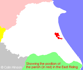
- For a detailed map of this parish see this parish boundaries map.
- For a more detailed map of the parishes in the riding please see the Yorkshire parish maps page.
- For a more detailed map of the county please see the Yorkshire map page.
- Here is a map showing the wapentakes for the county.
You can see maps centred on OS grid reference TA155456 (Lat/Lon: 53.893719, -0.243901), Sigglesthorne which are provided by:
- OpenStreetMap
- Google Maps
- StreetMap (Current Ordnance Survey maps)
- Bing (was Multimap)
- Old Maps Online
- National Library of Scotland (Old Ordnance Survey maps)
- Vision of Britain (Click "Historical units & statistics" for administrative areas.)
- English Jurisdictions in 1851 (Unfortunately the LDS have removed the facility to enable us to specify a starting location, you will need to search yourself on their map.)
- Magic (Geographic information) (Click + on map if it doesn't show)
- GeoHack (Links to on-line maps and location specific services.)
- All places within the same township/parish shown on an Openstreetmap map.
- Nearby townships/parishes shown on an Openstreetmap map.
- Nearby places shown on an Openstreetmap map.
- The 1914-18 War Memorial in Sigglesthorne Churchyard.
- The 1914-1918 War Memorial at Great Hatfield.
- This parish is covered by the following Society:
- The 1834 Electoral Roll for this parish