
Hide
Bradford
hide
Hide
hide
Hide
hide
Hide
Hide
The Ancient Parish of BRADFORD
[Transcribed information mainly from the early 1820s]
"BRADFORD, a market and parish-town, in Morley-division of Agbrigg and Morley, liberty of Pontefract; 6 miles from Bingley, 8 from Halifax, 10 from Leeds, Keighley, and Otley, 14 from Huddersfield, 15 from Wakefield, 34 from York, 196 from London. Market, Thursday. Fairs, March 3, June 17 and 18, December 9 and 10, for horned cattle, horses, pigs, &c. Bankers, Messrs. Peckover, Harris, and Co. draw on Messrs. Sir James Esdaile, and Co. 21, Lombard Street. Principal Inns, the Sun, and the Talbot. Pop. 13,064. The Church is a vicarage, dedicated to St. Peter, in the deanry of Pontefract, value, £20. Patron, Richard Fawcett, Esq. Here is also a Chapel of ease, called Christ's Church, in Darley Street, built by subscription, and consecrated in 1815." (There is further information for Bradford).Information on the following places in this Parish is contained on a supplementary page.
|
|
|
[Description(s) edited from various 19th century sources by Colin Hinson © 2013]
Hide
- Malcolm Hutton has indexed all the names from the book Pen and Pencil Pictures of Old Bradford which was published in 1890.
- Here are photographs of Cemeteries in the parish:
- North Bierley Cemetery.
- The Entrance to Bowling Cemetery, Burras Road.
- Bowling derelict Mortuary Chapel, Burras Road.
- Undercliffe Cemetery entrance, Undercliffe Lane.
- Monumental Inscriptions (South Bradford Local History Alliance website):
- On the South Bradford Local History Alliance website:
- The transcription of the 1891 census for Eccleshill by Enumeration Districts:
- The transcription of the 1901 census for Eccleshill by Enumeration Districts:
- Here are photographs of Churches in the Ancient parish of Bradford:
- The Churches in Wilsden, Heaton, Saltaire, Shipley, Frizinghall in Bradford Ancient Parish
- The Church of England Churches in Bradford Ancient Parish
- The Baptist and Methodist Churches in Bradford Ancient Parish
- The Churches of other denominations in Bradford Ancient Parish
- Mike Dinn has generated a map showing the inner Bradford Roman Catholic churches superimposed on a modern map.
- Here is a list of Churches in the Bradford area taken from the Bradford year book for 1927-8, transcribed for Genuki by Joan Gaskin.
- A transcription of Bradford Westgate Baptist Church History
- A transcription of Shipley Bethel Baptist Church History
- A transcription of Allerton Bethel sandy Lane Baptist Church History
- A transcription of Bradford Sion Baptist Church History
- A transcription of Clayton Baptist Church History
- A transcription of Bradford Grange Road tetley Street Memorial Baptist Church History
- A transcription of Bradford Infirmary Street Bethel Baptist Church History
- A transcription of Denholme Baptist Church History
- A transcription of Bradford Trinity Horton Lane Baptist Church History
- A transcription of Heaton Baptist Church History
- A transcription of Hallfield Baptist Church History
- A transcription of Allerton Central Baptist Church History
- A transcription of Shipley Rosse Street Baptist Church History
- A transcription of Bradford Ripley Street Ebenezer Baptist Church History
- A transcription of Girlington Baptist Church History
- A transcription of Eccleshill Baptist Church History
- A transcription of Marshfield Baptist Church History
- A transcription of Charlestown Baptist Church History
- A transcription of Haworth Baptist Church History
- A transcription of Horkinstone Baptist Church History
- A transcription of the Allerton Congregational Church History
- A transcription of the Bradford Congregational Church History
- A transcription of the Bradford-Chapel Lane Congregational Church History
- A transcription of the Bradford-Horton Lane Chapel Congregational Church History
- A transcription of the Bradford-Salem Chapel Congregational Church History
- A transcription of the Bradford-College Chapel Congregational Church History
- A transcription of the Bradford-Greenfield Chapel Congregational Church History
- A transcription of the Bradford-Lister Hills Chapel Congregational Church History
- A transcription of the Bradford-Bowling Chapel Congregational Church History
- A transcription of the Bradford-Great Horton Congregational Church History
- A transcription of the Bradford-Wibsey Congregational Church History
- A transcription of the Bradford-Holme Lane Congregational Church History
- A transcription of the Bradford-Saltaire Congregational Church History
- A transcription of the Denholme Congregational Church History
- A transcription of the Eccleshill-Salem Chapel Congregational Church History
- A transcription of the Wilsden Congregational Church History
- A transcription of the Windhill Congregational Church History
- Transcript of the entry for Bradford in the "Collections relative to Churches and Chapels".
- Transcript of the entry for Bradford Christ Church in the "Collections relative to Churches and Chapels".
- Transcript of the entry for Haworth in the "Collections relative to Churches and Chapels".
- Transcript of the entry for Horton in the "Collections relative to Churches and Chapels".
- Transcript of the entry for North Bierley in the "Collections relative to Churches and Chapels".
- Transcript of the entry for Shipley cum Heaton in the "Collections relative to Churches and Chapels".
- Transcript of the entry for Thornton in the "Collections relative to Churches and Chapels".
- Transcript of the entry for Wibsey in the "Collections relative to Churches and Chapels".
- Transcript of the entry for Wilsden in the "Collections relative to Churches and Chapels".
- On the South Bradford Local History Alliance website:
- A record of the pew holders in Wibsey Chapel (Holy Trinity, Low Moor).
- Holy Trinity, Low Moor; St Mark's, Low Moor; St Andrew's, Oakenshaw; St Mary's, Wyke and St Paul's, Buttershaw Parish records
- Low Moor, Oakenshaw, Wibsey, Wyke and Bierley Non-conformist records
- Bradford, Chapel Lane Presbyterian / Unitarian records
- The whereabouts and dates of the Registers etc. for the Parish of Bradford.
- The whereabouts and dates of the Registers etc. for the Chapelry of Haworth.
- The whereabouts and dates of the Registers etc. for the Chapelry of Horton.
- The whereabouts and dates of the Registers etc. for the Chapelry of Shipley.
- The whereabouts and dates of the Registers etc. for the Chapelry of Thornton.
- The whereabouts and dates of the Registers etc. for the Chapelry of Wibsey.
- The whereabouts and dates of the Registers etc. for the Chapelry of Wilsden.
- The list of Incumbents in Haworth Parish Church.
- The List of Priests of Lees. Bradford 1920-1937 Voting Registers notes Bradford Voting Registers Street positions, 1920-1937 Bradford Voting Registers notes Bradford Voting Registers Street positions
- Discover Bradford, photographs and lots more of Bradford and the surrounding district.
- Garry Stockdill's Yorksview website contains a description and photographs of:
- North Bierley, White's Directory 1837 (South Bradford Local History Alliance website)
- Transcript of the entry of "professions and trades" in the Baines's Directory and Gazetteer, Vol I, West Riding.
- Transcript of the entry of "professions and trades" in the Pigot's 1829 Directory, Yorkshire section.
- Transcript of the entry of "professions and trades" in the Pigot's 1834 Directory, Yorkshire section.
- A comprehensive list of the Bradford Borough streets for 1853 to 1915 associated with the relevant Voting Registers (see below)
- A comprehensive list of the Bradford Borough streets for 1920 to 1937 associated with the relevant Voting Registers (see below)
- There is further information about this parish from the Pigot's 1829 Directory, Yorkshire section.
- There is further information about this parish from the Pigot's 1834 Directory, Yorkshire section.
- There is further information about this parish from the National Gazetteer 1868, Yorkshire extracts.
- There is further information about this parish from the Lewis's Topographical Dictionary of England, Yorkshire extracts.
- There is further information about this parish from the Stephen Whatley's Gazetteer 1750, Yorkshire extracts.
- An index of the Bradford streets, lanes, roads, etc. transcribed from Whites 1853 Directory and Gazetteer.
- Ask for a calculation of the distance from Bradford to another place.
- The Low Moor Local History Group pages have articles on the history of Low Moor.
- The Bradford Timeline website
- The Bradford Timeline Flickr Collection of photographs.
- T' History o't Haworth Railway in the local dialect, by William Wright poet of Haworth (known as Bill o'th Hoylus End) transcribed by Alan Longbottom.
- A transcription of the Allerton Congregational Church History
- The Manorial records for Royds Hall Manor (North Bierley township) are available on the South Bradford Local History Alliance website.
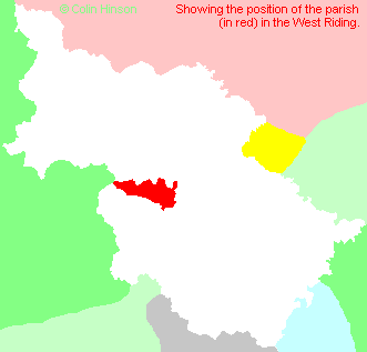
- For a detailed map of this parish see this parish boundaries map.
- For a more detailed map of the parishes in the riding please see the Yorkshire parish maps page.
- For a more detailed map of the county please see the Yorkshire map page.
- Here is a map showing the wapentakes for the county.
You can see maps centred on OS grid reference SE167330 (Lat/Lon: 53.793048, -1.747975), Bradford which are provided by:
- OpenStreetMap
- Google Maps
- StreetMap (Current Ordnance Survey maps)
- Bing (was Multimap)
- Old Maps Online
- National Library of Scotland (Old Ordnance Survey maps)
- Vision of Britain (Click "Historical units & statistics" for administrative areas.)
- English Jurisdictions in 1851 (Unfortunately the LDS have removed the facility to enable us to specify a starting location, you will need to search yourself on their map.)
- Magic (Geographic information) (Click + on map if it doesn't show)
- GeoHack (Links to on-line maps and location specific services.)
- All places within the same township/parish shown on an Openstreetmap map.
- Nearby townships/parishes shown on an Openstreetmap map.
- Nearby places shown on an Openstreetmap map.
- The War memorials at Low Moor and Bank Foot have been transcribed by the South Bradford History Alliance.
- A transcription of the The Greengates Cenotaph
- The World War I Memorial Plaque in St. Mary's Church, Oxenhope.
- The World War I Memorial Plaque in St. Mary's Church, Oxenhope.
- The Roll of Honour for both of the World Wars in St. Michael's Church, Haworth.
- The Memorial Plaque in Haworth Parish Church.
- The War Memorial at Haworth.
- A transcription by Tana Johnson of the members of the Second West Yorks Cavalry, 1845.
- The Monumental Inscriptions for Holy Trinity, Low Moor (Wibsey Chapel), St. Mark's, Low Moor and St. Paul's, Buttershaw. are available on the South Bradford Local History Alliance website. (Work in progress).
- Additionally on the SBLHA site, a transcription of the Gravebook for St. Paul's Buttershaw is available.
- The following places are within the boundaries of this (ancient) parish, but I have no further information on them other than the Ordnance Survey Landranger Grid reference shown:
- (SE072328) Denholme Clough
- (SE197292) East Bierley
- (SE141342) Girlington
- (SE083357) Harecroft
- (SE093309) Mountain
- (SE029349) Shaw
- A list of people aged 90 or more who died in the Bradford district between 1841 and 1865, transcribed by Roy Stockdill.
- In 1889, Ben Tillett came to notice for the part he played in the London Dock strike. As a result of his activities, he was asked to stand as Parliamentary candidate for the Eastern Division of Bradford, but replied 'I shall never seek Parliamentary honours until I have the hearts and consciences of a constituency to back me up in the most spontaneous fashion'. A petition, was signed by over 1000 Bradford people whose names and other information are given in the results of Carol Bartlett's research into the Tillett Petition.
- On the South Bradford Local History Alliance website:
- Mike Dinn has transcribed five of the School Magazines (from 1925,1939,1950, 1969 and 1975) from St Bede's Grammar School Bradford
- The South Bradford Local History Alliance has transcribed a lot of local information.
- The Low Moor Local History Group pages have lots of information about Low Moor history.
- This parish is covered (or partly covered) by the following Societies:
- North Bierley Land Tax (South Bradford Local History Alliance website)
- A list of those paying the 1379 Subsidy Rolls (Poll Tax) for this parish.
- A list of 32 people who had Settlement Certificates for the township of Shipley from 1698 to 1775.
- The Parliamentary Registers for the borough of Bradford were issued in various formats. These formats are as follows:
- 1853-1867, completely alphabetical by surname for the whole of Bradford, Bowling, Horton and Manningham townships.
- 1868-1878, alphabetical by surname by wards for the above townships.
- 1881-1883, as above but wards split because of the number of voters and additional wards in 1883.
- 1884-1915, wards split, streets given in alphabetical order, then by house number.
- Please be sure to read these notes for this section (1853-1915)!
- Here are the Parliamentary Voting registers:
- Here are the Parochial Voting Registers. It should be noted that some of the wards are split within the years.
- The Parochial Registers for 1896 to 1909
- Here are the Parliamentary and Local Voting Registers for 1920-1937 (work in progress).
- Please be sure to read these notes for this section (1920-1937)!
- The Parliamentary and Local Registers for 1920 to 1937